
Xinjiang Agricultural Sciences ›› 2024, Vol. 61 ›› Issue (6): 1468-1476.DOI: 10.6048/j.issn.1001-4330.2024.06.021
• Plant Protection • Soil Fertilizero Water Saving Irrigation • Previous Articles Next Articles
ZHANG Zhenfei1( ), GUO Jing2, YAN An1(), YUAN Yilin1, XIAO Shuting1, HOU Zhengqing1, SUN Zhe1
Received:2023-10-28
Online:2024-06-20
Published:2024-08-08
Correspondence author:
YAN An
Supported by:
张振飞1(), 郭靖2, 颜安1(), 袁以琳1, 肖淑婷1, 侯正清1, 孙哲1
通讯作者:
颜安
作者简介:张振飞(1998-),男,河南安阳人,硕士研究生,研究方向为农业信息化,(E-mail)1291716283@qq.com
基金资助:CLC Number:
ZHANG Zhenfei, GUO Jing, YAN An, YUAN Yilin, XIAO Shuting, HOU Zhengqing, SUN Zhe. Study on extraction of apple tree crown width at different flight altitudes using multi-spectral UAV[J]. Xinjiang Agricultural Sciences, 2024, 61(6): 1468-1476.
张振飞, 郭靖, 颜安, 袁以琳, 肖淑婷, 侯正清, 孙哲. 基于多光谱无人机不同飞行高度下苹果树冠幅信息的提取[J]. 新疆农业科学, 2024, 61(6): 1468-1476.
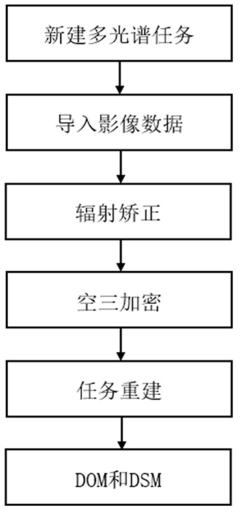
Fig.1 UAV image stitching process
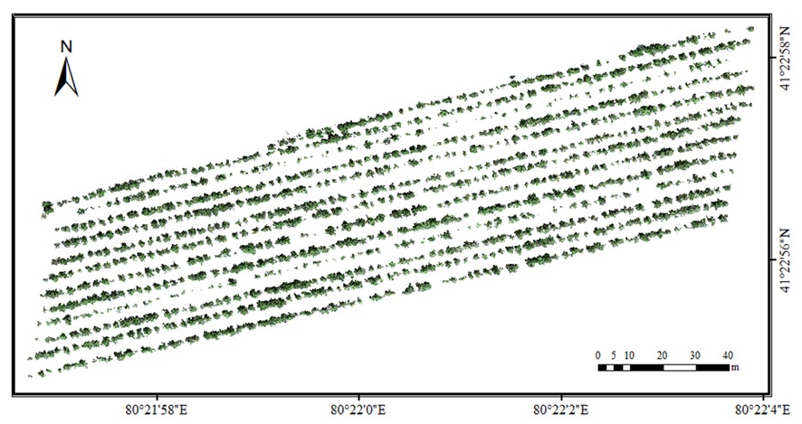
Fig.2 Tree crown area extraction results at 30 m flight altitude
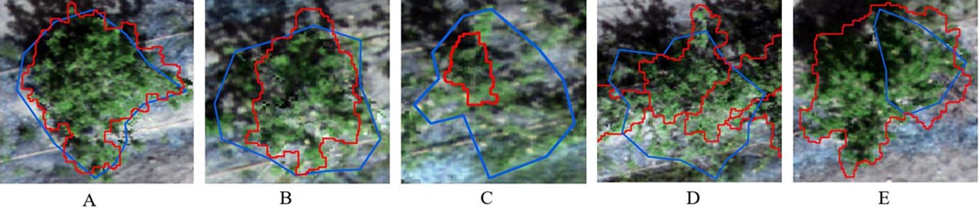
Fig.3 Five segmentation situations Note:Match A;B is close to matching;C is lost;D over segmentation; Under segmentation of E;Blue as reference tree crown; Red indicates automatic segmentation of tree crown
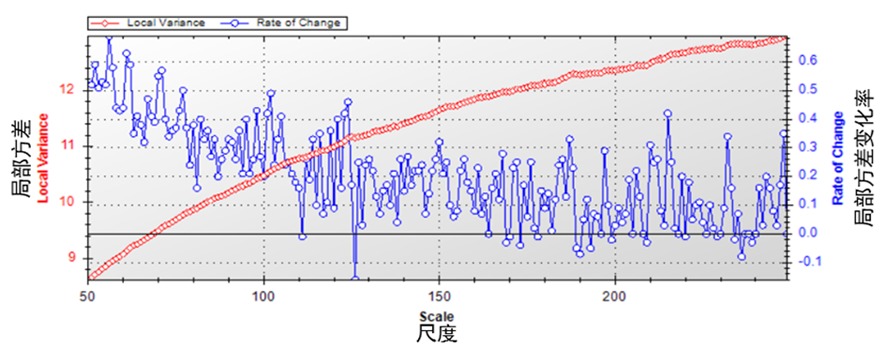
Fig.4 Optimal scale line char

Fig.5 Automatic tree crown segmentation results at different drone flight heights Note:a:Automatic segmentation a flight altitude of 30 m;b:Automatic segmentation at a flight altitude of 60 m;c:Automatic segmentation at a flight altitude of 90 m
| 飞行高度 Flying altitude (m) | 匹配率 Matching rate (%) | 接近匹配率 Close matching rate (%) | 丢失率 Loss rate (%) | 过分割率 Over-segmentation rate(%) | 欠分割率 Under-segmentation rate(%) |
|---|---|---|---|---|---|
| 30 60 90 | 47.00 39.00 29.00 | 37.00 42.00 44.00 | 4.00 4.00 4.00 | 5.00 7.00 9.00 | 7.00 8.00 14.00 |
Tab.1 Tree crown segmentation statistics
| 飞行高度 Flying altitude (m) | 匹配率 Matching rate (%) | 接近匹配率 Close matching rate (%) | 丢失率 Loss rate (%) | 过分割率 Over-segmentation rate(%) | 欠分割率 Under-segmentation rate(%) |
|---|---|---|---|---|---|
| 30 60 90 | 47.00 39.00 29.00 | 37.00 42.00 44.00 | 4.00 4.00 4.00 | 5.00 7.00 9.00 | 7.00 8.00 14.00 |
| 飞行高度 Flying altitude (m) | 精度范围 Accuracy range (%) | 平均提取精度 Average extraction accuracy(%) | R2 | RMSE(m) |
|---|---|---|---|---|
| 30-EW 30-NS 60-EW 60-NS 90-EW 90-NS | 72.99~99.90 79.40~98.99 70.80~98.91 78.74~98.99 71.53~99.47 41.36~98.96 | 90.43 91.86 89.54 91.09 89.16 88.60 | 0.770 2 0.801 5 0.724 3 0.750 9 0.705 6 0.714 8 | 0.204 7 0.228 5 0.226 4 0.256 7 0.228 9 0.306 3 |
Tab.2 Regression statistics of extracted crown width and measured crown width
| 飞行高度 Flying altitude (m) | 精度范围 Accuracy range (%) | 平均提取精度 Average extraction accuracy(%) | R2 | RMSE(m) |
|---|---|---|---|---|
| 30-EW 30-NS 60-EW 60-NS 90-EW 90-NS | 72.99~99.90 79.40~98.99 70.80~98.91 78.74~98.99 71.53~99.47 41.36~98.96 | 90.43 91.86 89.54 91.09 89.16 88.60 | 0.770 2 0.801 5 0.724 3 0.750 9 0.705 6 0.714 8 | 0.204 7 0.228 5 0.226 4 0.256 7 0.228 9 0.306 3 |
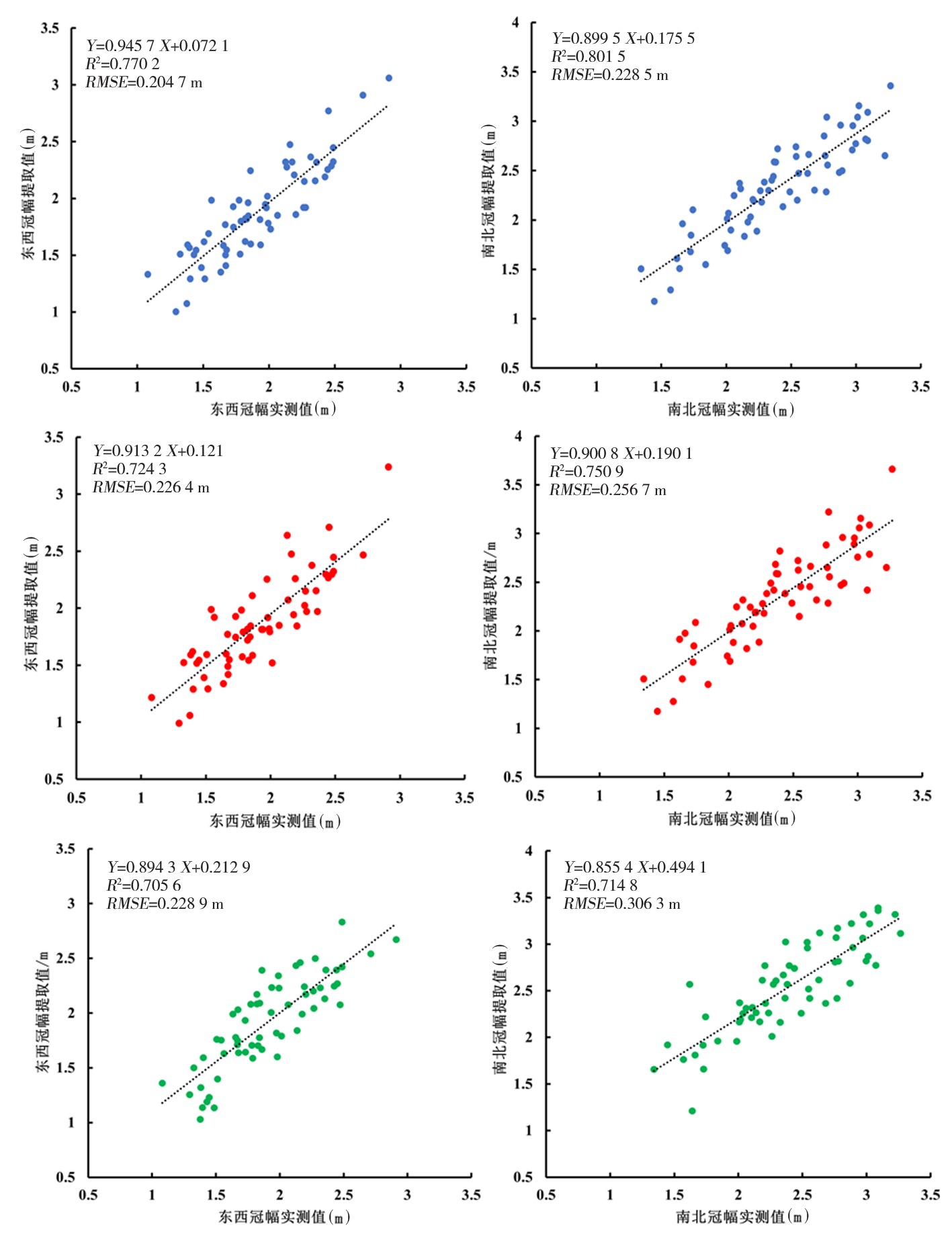
Fig.6 Different flight altitudes scatter plot of average extracted crown width and measured values Note:Blue,red,green respectively 30,60,90 m scatter plot of fight altitude
| [1] | 赵祎, 马力群, 罗云波, 等. 贮藏温度对嘎啦苹果贮藏期及货架期品质的影响[J]. 保鲜与加工, 2018, 18(3): 8-14. |
| ZHAO Yi, MA Liqun, LUO Yunbo, et al. Influence of storage temperature on quality of gala apple during storage and shelf life[J]. Storage and Process, 2018, 18(3): 8-14. | |
| [2] | 郭靖, 韩政伟, 张振飞, 等. 苹果新品种王林1号的选育[J]. 果树学报, 2023, 40(2): 386-389. |
| GUO Jing, HAN Zhengwei, ZHANG Zhenfei, et al. Breeding report of a new apple cultivar Wanglin 1[J]. Journal of Fruit Science, 2023, 40(2): 386-389. | |
| [3] | 覃先林, 李增元, 易浩若. 高空间分辨率卫星遥感影像树冠信息提取方法研究[J]. 遥感技术与应用, 2005, 20(2): 228-232. |
| QIN Xianlin, LI Zengyuan, YI Haoruo. Extraction method of tree crown using high-resolu tion satellite image[J]. Remote Sensing Technology and Application, 2005, 20(2): 228-232. | |
| [4] | 史云, 沈磊, 陈山, 等. 基于低空遥感的果树冠层信息提取方法研究[J]. 中国农业信息, 2022, 34(1): 1-10. |
| SHI Yun, SHEN Lei, CHEN Shan, et al. Research on the extraction method of fruit tree canopy information based on low-altitude remote sensing[J]. China Agricultural Informatics, 2022, 34(1): 1-10. | |
| [5] | 万祖毅, 田永中, 刘旭东, 等. 基于轻小型无人机影像的柑橘树株数提取[J]. 湖北农机化, 2020,(7): 140-144. |
| WAN Zuyi, TIAN Yongzhong, LIU Xudong, et al. Extracting the Number of Citrus Trees Based on Light and Small UAV Images[J]. Hubei Agricultural Mechanization, 2020,(7): 140-144. | |
| [6] | 祁媛, 徐伟诚, 王林琳, 等. 基于无人机遥感影像的沙糖橘果树提取方法研究[J]. 华南农业大学学报, 2020, 41(6): 126-133. |
| QI Yuan, XU Weicheng, WANG Linlin, et al. Study on the extraction method of sugar tangerine fruit trees based on UAV remote sensing images[J]. Journal of South China Agricultural University, 2020, 41(6): 126-133. | |
| [7] | Yang H B, Zhao J, Lan Y B, et al. Fraction vegetation cover extraction of winter wheat based on RGB image obtained by UAV[J]. International Journal of Precision Agricultural Aviation, 2018, 1(1): 54-61. |
| [8] | 牛亚晓, 张立元, 韩文霆, 等. 基于无人机遥感与植被指数的冬小麦覆盖度提取方法[J]. 农业机械学报, 2018, 49(4): 212-221. |
| NIU Yaxiao, ZHANG Liyuan, HAN Wenting, et al. Fractional vegetation cover extraction method of winter wheat based on UAV remote sensing and vegetation index[J]. Transactions of the Chinese Society for Agricultural Machinery, 2018, 49(4): 212-221. | |
| [9] |
颜安, 郭涛, 陈全家, 等. 基于无人机影像的棉花株高预测[J]. 新疆农业科学, 2020, 57(8): 1493-1502.
DOI |
|
YAN An, GUO Tao, CHEN Quanjia, et al. Prediction of cotton plant height based on UAV image[J]. Xinjiang Agricultural Sciences, 2020, 57(8): 1493-1502.
DOI |
|
| [10] | 周辰琴, 余拥军, 方陆明, 等. 飞行高度与郁闭度对水杉冠幅提取影响的研究[J]. 林业资源管理, 2022,(1): 150-156. |
| ZHOU Chenqin, YU Yongjun, FANG Luming, et al. Effects of flight height and canopy density on canopy extraction of Metasequoia glyptostroboides[J]. Forest Resources Management, 2022,(1): 150-156. | |
| [11] | Wang L, Gong P, Biging G S. Individual tree-crown delineation and treetop detection in high-spatial-resolution aerial imagery[J]. Photogrammetric Engineering & Remote Sensing, 2004, 70(3): 351-357. |
| [12] |
郭昱杉, 刘庆生, 刘高焕, 等. 基于标记控制分水岭分割方法的高分辨率遥感影像单木树冠提取[J]. 地球信息科学学报, 2016, 18(9): 1259-1266.
DOI |
| GUO Yushan, LIU Qingsheng, LIU Gaohuan, et al. Individual tree crown extraction of high resolution image based on marker-controlled watershed segmentation method[J]. Journal of Geo-Information Science, 2016, 18(9): 1259-1266. | |
| [13] | 徐永胜, 刘浩然, 范伟伟, 等. 基于分水岭算法的无人机不同飞行高度下林木冠幅提取研究[J]. 西北林学院学报, 2021, 36(3): 197-202, 259. |
| XU Yongsheng, LIU Haoran, FAN Weiwei, et al. Extraction of forest stand crown width at different flying heights of UAV based on watershed algorithm[J]. Journal of Northwest Forestry University, 2021, 36(3): 197-202, 259. | |
| [14] | 孙钊, 潘磊, 孙玉军. 基于无人机影像的高郁闭度杉木纯林树冠参数提取[J]. 北京林业大学学报, 2020, 42(10): 20-26. |
| SUN Zhao, PAN Lei, SUN Yujun. Extraction of tree crown parameters from high-density pure Chinese fir plantations based on UAV images[J]. Journal of Beijing Forestry University, 2020, 42(10): 20-26. | |
| [15] | 万祖毅. 基于无人机遥感的柑橘果树信息提取及应用研究[D]. 重庆: 西南大学, 2020. |
| WAN Zuyi. Extraction and Application of Citrus Fruit Tree Information Based on UAV Remote Sensing[D]. Chongqing: Southwest University, 2020. | |
| [16] | 王雅佩, 王振锡, 李擎, 等. 基于无人机影像的天山云杉林伐后更新地林分密度估测研究[J]. 中南林业科技大学学报, 2020, 40(5): 57-66. |
| WANG Yapei, WANG Zhenxi, LI Qing, et al. Research on estimation of stand density of regenerate Picea schrenkiana var. tianshanica based on UAV images[J]. Journal of Central South University of Forestry & Technology, 2020, 40(5): 57-66. | |
| [17] | 郭旭展, 陈巧, 张晓芳, 等. 基于无人机高分辨率影像的油松新造林健康树冠提取[J]. 林业科学, 2022, 58(10): 111-120. |
| GUO Xuzhan, CHEN Qiao, ZHANG Xiaofang, et al. Extraction of healthy canopy of new afforestation for Pinus tabulaeformis based on UAV high-resolution image[J]. Scientia Silvae Sinicae, 2022, 58(10): 111-120. | |
| [18] | 刘方舟, 刘浩, 云挺. 基于分水岭优化思想的单木信息分割算法[J]. 林业工程学报, 2020, 5(5): 109-116. |
| LIU Fangzhou, LIU Hao, YUN Ting. Individual tree crown separation using the improved watershed method[J]. Journal of Forestry Engineering, 2020, 5(5): 109-116. | |
| [19] | Erikson M. Segmentation of individual tree crowns in colour aerial photographs using region growing supported by fuzzy rules[J]. Canadian Journal of Forest Research, 2003, 33(8): 1557-1563. |
| [20] | Jing L H, Hu B X, Li J L, et al. Automated delineation of individual tree crowns from lidar data by multi-scale analysis and segmentation[J]. Photogrammetric Engineering & Remote Sensing, 2012, 78(12): 1275-1284. |
| [21] | 王枚梅, 林家元, 林沂, 等. 基于无人机可见光影像的亚高山针叶林树冠参数信息自动提取[J]. 林业资源管理, 2017,(4): 82-88. |
| WANG Meimei, LIN Jiayuan, LIN Yi, et al. Subalpine coniferous forest crown information automatic extraction based on optical UAV remote sensing imagery[J]. Forest Resources Management, 2017,(4): 82-88. | |
| [22] | 孙钊. 基于无人机航拍图像的杉木树冠参数提取与模型研建[D]. 北京: 北京林业大学, 2020. |
| SUN Zhao. Extraction of Tree Crown Parameters and Model Developmentbased on UAV Image[D]. Beijing: Beijing Forestry University, 2020. | |
| [23] | 李文静, 王瑞瑞, 石伟, 等. 基于无人机多光谱影像的单木树冠提取方法[J]. 福建农林大学学报(自然科学版), 2020, 49(5): 639-645. |
| LI Wenjing, WANG Ruirui, SHI Wei, et al. Crown extraction method of individual tree based on multi-spectral image of UAV[J]. Journal of Fujian Agriculture and Forestry University (Natural Science Edition), 2020, 49(5): 639-645. | |
| [24] | 束美艳, 李世林, 魏家玺, 等. 基于无人机平台的柑橘树冠信息提取[J]. 农业工程学报, 2021, 37(1): 68-76. |
| SHU Meiyan, LI Shilin, WEI Jiaxi, et al. Extraction of citrus crown parameters using UAV platform[J]. Transactions of the Chinese Society of Agricultural Engineering, 2021, 37(1): 68-76. | |
| [25] | 张玉薇, 陈棋, 田湘云, 等. 基于UAV可见光遥感的单木冠幅提取研究[J]. 西部林业科学, 2022, 51(3): 49-59. |
| ZHANG Yuwei, CHEN Qi, TIAN Xiangyun, et al. Individual tree crown extraction based on UAV visible light remote sensing technology[J]. Journal of West China Forestry Science, 2022, 51(3): 49-59. | |
| [26] | 于旭宅, 王瑞瑞, 陈伟杰. 改进分水岭算法在无人机遥感影像树冠分割中的应用[J]. 福建农林大学学报(自然科学版), 2018, 47(4): 428-434. |
| YU Xuzhai, WANG Ruirui, CHEN Weijie. Forest canopy segmentation of UAV remote sensing images using improved watershed algorithm[J]. Journal of Fujian Agriculture and Forestry University (Natural Science Edition), 2018, 47(4): 428-434. | |
| [27] | 金忠明, 曹姗姗, 王蕾, 等. 基于U-Net和分水岭算法的无人机单木树冠提取方法[J]. 西北林学院学报, 2020, 35(6): 194-204. |
| JIN Zhongming, CAO Shanshan, WANG Lei, et al. A method for individual tree-crown extraction from UAV remote sensing image based on U-net and watershed algorithm[J]. Journal of Northwest Forestry University, 2020, 35(6): 194-204. | |
| [28] | 郑鑫, 王瑞瑞, 靳茗茗. 基于形态学阈值标记分水岭算法的高分辨率影像单木树冠提取[J]. 中南林业调查规划, 2017, 36(4): 30-35, 57. |
| ZHENG Xin, WANG Ruirui, JIN Mingming. Extraction of high-resolution images of single tree crown based on watershed algorithm with morphological threshold mark[J]. Central South Forest Inventory and Planning, 2017, 36(4): 30-35, 57. |
| [1] | DAI Aimei, YE Mengdi, DING Zhimei, WANG Zhihui, QIAO Xiaoyan, WANG Xiaowu, FU Kaiyun, JIA Zunzun, YE Xiaoqin, Tuerxun Ahemati, KANG Jian, DING Xinhua, GUO Wenchao. Evaluation on the efficacy and safety of dif ferent application methods of flumioxazinone in controlling weeds in corn field [J]. Xinjiang Agricultural Sciences, 2024, 61(S1): 28-34. |
| [2] | ZHANG Zhenfei, GUO Jing, YAN An, HOU Zhengqing, YUAN Yilin, XIAO Shuting, SUN Zhe. Study on extraction of apple tree height at different flight altitudes using multispectral UAV [J]. Xinjiang Agricultural Sciences, 2024, 61(7): 1710-1716. |
| [3] | SHAO Yajie, LI Ke, DING Wenhao, LIN Tao, CUI Jianping, GUO Rensong, WANG Liang, WU Fengquan, WANG Xin, TANG Qiuxiang. Study on cotton biomass estimation based on multi-spectral imaging features of unmanned aerial vehicle [J]. Xinjiang Agricultural Sciences, 2024, 61(6): 1328-1335. |
| [4] | GENG Songyi, SUN Hongtao, ZHAO Weiqi, WANG Mei, MA Rong. Survey of the occurrence of apple tree Valsa canker and screening of new control agents [J]. Xinjiang Agricultural Sciences, 2024, 61(6): 1461-1467. |
| [5] | LI Xuerui, ZHAI Menghua, XU Xinlong, SUN Minghui, ZHANG Jusong. Effects of spraying different concentrations of SAH by UAV on cotton growth and development [J]. Xinjiang Agricultural Sciences, 2024, 61(5): 1085-1093. |
| [6] | ZHANG Yijia, CHENG Ping, WANG Lei, WU Sheng li. Effects of different irrigation rates on physiological characteristics, yield and quality of dwarfed close-planted apple trees [J]. Xinjiang Agricultural Sciences, 2024, 61(5): 1140-1150. |
| [7] | HU Zhiwei, YANG Na, TANG Zhihui, ZHI Jinhu, CHI Chunming. Effects of water and fertilizer coupling application on the fruit quality of main trunk apple trees [J]. Xinjiang Agricultural Sciences, 2024, 61(10): 2458-2464. |
| [8] | QIN Yekangyang, LI Jiaxin, JIN Guili, LIU Wenhao, MA Jian, LI Wenxiong, CHEN Mentian. Identification of main plants in desert grassland Seriphidium transiliense based on UAV remote sensing and CNN ResNet 18 [J]. Xinjiang Agricultural Sciences, 2024, 61(10): 2547-2556. |
| [9] | QIN Pengliang, ZHOU Xiao, Kahsay Tadesse Mawcha, WANG Shuang, LI Jiaqi, LIU Ying, ZHANG Na, YANG Wenxiang. EMS mutants of wheat hengguan 35 and identification of the mutants resistant to fusarium crown rot [J]. Xinjiang Agricultural Sciences, 2023, 60(9): 2231-2238. |
| [10] | DONG Deyu, CHENG Yukun, WANG Rui, LEI Junjie, WANG Wei, CHEN Chuanxin, ZHENG Yongqiang, GENG Hongwei. Retrieval of wheat photosynthetic parameters at different growth stages based on UAV multispectral images [J]. Xinjiang Agricultural Sciences, 2023, 60(6): 1308-1318. |
| [11] | FENG Fan, XIE Kaiyun, Aibibula Yimamu, WAN Jiangchun. Effects of intercrop forages on weed control, soil and tree nutrients in orchards [J]. Xinjiang Agricultural Sciences, 2023, 60(4): 982-991. |
| [12] | LI Yapeng, ZHANG Wangbin, YI Zibo. Analysis of Pathogen Species and Their Genetic Relationship of Apple Tree canker [J]. Xinjiang Agricultural Sciences, 2022, 59(3): 700-706. |
| [13] | ZHANG Donghai, WEI Junmei, CHEN Bing, JI Guangpeng, WANG Fan, NIU Linglei. Evaluation on Effects of Herbicide Sprayed on Cotton Fields before Sowing by UAV [J]. Xinjiang Agricultural Sciences, 2022, 59(12): 3022-3029. |
| [14] | FU Kaiyun, WANG Zhihui, DING Xinhua, Tursun Ahmat, WANG Xiaowu, JIA Zunzun, Arziguli Rouzi, GUO Wenchao. Influence of Pesticide Reduction and Synergist on Utilization Rates and Droplets Distribution in Corn Field [J]. Xinjiang Agricultural Sciences, 2022, 59(11): 2675-2681. |
| [15] | ZHU Xiaofeng, XU Binqiang, SONG Bo, XIONG Jinming, GAO Guanrong, YAN Xiaojing, Abudukeyoumu Kader, YANG Sen. Field Control Evaluation of Plant Protection UAV Spreading Pesticide against Chromaphis juglandicola and Cnidocampa flavescens in Walnut Orchard [J]. Xinjiang Agricultural Sciences, 2021, 58(11): 2077-2083. |
| Viewed | ||||||||||||||||||||||||||||||||||||||||||||||||||
|
Full text 34
|
|
|||||||||||||||||||||||||||||||||||||||||||||||||
|
Abstract 110
|
|
|||||||||||||||||||||||||||||||||||||||||||||||||