
Xinjiang Agricultural Sciences ›› 2022, Vol. 59 ›› Issue (1): 223-230.DOI: 10.6048/j.issn.1001-4330.2022.01.026
• Animal Husbandry Veterinarian·Agricultural Information·Prataculture·Agricultural Eeconomy • Previous Articles Next Articles
Hazirtiali Keyim( ), LI Xinguo(), ZHAO Hui, Mamattursun Eziz
Received:2021-01-19
Online:2022-01-20
Published:2022-02-18
Correspondence author:
LI Xinguo
Supported by:
艾孜提艾力·克依木(), 李新国(), 赵慧, 麦麦提吐尔逊·艾则孜
通讯作者:
李新国
作者简介:艾孜提艾力·克依木(1995-),男,新疆乌鲁木齐人,硕士研究生,研究方向为干旱区土壤资源变化及其遥感应用,(E-mail) alikeyim@163.com
基金资助:CLC Number:
Hazirtiali Keyim, LI Xinguo, ZHAO Hui, Mamattursun Eziz. Hyperspectral Estimation of Surface Soil Organic Matter Content in the Oasis Based on Geographically Weighted Regression Model[J]. Xinjiang Agricultural Sciences, 2022, 59(1): 223-230.
艾孜提艾力·克依木, 李新国, 赵慧, 麦麦提吐尔逊·艾则孜. 基于地理加权回归模型的绿洲土壤表层有机质含量高光谱估算[J]. 新疆农业科学, 2022, 59(1): 223-230.
Add to citation manager EndNote|Ris|BibTeX
URL: http://www.xjnykx.com/EN/10.6048/j.issn.1001-4330.2022.01.026
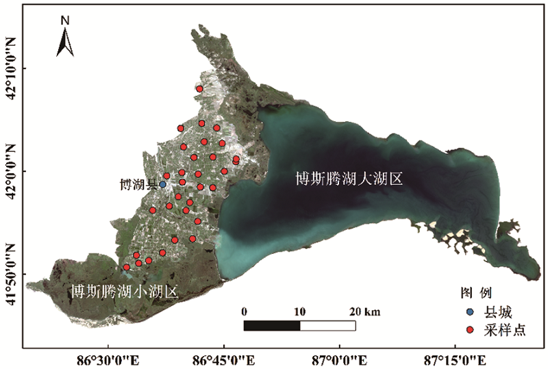
Fig.1 Schematic of study area and sampling points
| 数据集 Dataset | 样本数 Samples | 最小 Minimum | 最大值 Maximum | 均值 Mean | 标准误差 Standard deviation | 变异系数 Coefficient of variation |
|---|---|---|---|---|---|---|
| 全集 Total | 31 | 2.37 | 51.47 | 21.20 | 10.81 | 0.50% |
| 建模集Calibration dataset | 20 | 5.09 | 51.47 | 21.81 | 10.86 | 0.55% |
| 验证集Validation dataset | 10 | 9.54 | 41.92 | 21.88 | 9.97 | 0.46% |
Table 1 Statistical characteristics of soil organic matter content
| 数据集 Dataset | 样本数 Samples | 最小 Minimum | 最大值 Maximum | 均值 Mean | 标准误差 Standard deviation | 变异系数 Coefficient of variation |
|---|---|---|---|---|---|---|
| 全集 Total | 31 | 2.37 | 51.47 | 21.20 | 10.81 | 0.50% |
| 建模集Calibration dataset | 20 | 5.09 | 51.47 | 21.81 | 10.86 | 0.55% |
| 验证集Validation dataset | 10 | 9.54 | 41.92 | 21.88 | 9.97 | 0.46% |
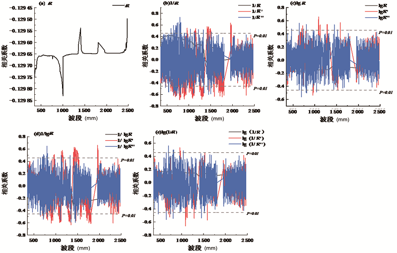
Fig.2 Correlation soil organic matter and spectral transformation of reflectance
| 光谱变换 Spectrum transform | 特征波段 Characteristic waveband | R2 |
|---|---|---|
| 1/R' | 788,796,896,1 298 | -0.688,-0.685,-0.679,-0.683 |
| 1/R″ | 753,797,803,814 | 0.638,0.733,0.635,0.643 |
| lgR' | 1 087,1 088,1 285,1 586 | 0.661,0.544,0.651,0.572 |
| lgR″ | 645,694,805,1 450 | 0.562,-0.561,0.546,0.539 |
| 1/lgR' | 1 349,1 422,1 441,1 958 | -0.633,0.628,0.625,0.658 |
| 1/lgR″ | 797,1 348,1 450,1 456 | 0.645,-0.586,-0.596,-0.559 |
Table 2 Organic matter model bands and spectral transformation forms through extremely isability test
| 光谱变换 Spectrum transform | 特征波段 Characteristic waveband | R2 |
|---|---|---|
| 1/R' | 788,796,896,1 298 | -0.688,-0.685,-0.679,-0.683 |
| 1/R″ | 753,797,803,814 | 0.638,0.733,0.635,0.643 |
| lgR' | 1 087,1 088,1 285,1 586 | 0.661,0.544,0.651,0.572 |
| lgR″ | 645,694,805,1 450 | 0.562,-0.561,0.546,0.539 |
| 1/lgR' | 1 349,1 422,1 441,1 958 | -0.633,0.628,0.625,0.658 |
| 1/lgR″ | 797,1 348,1 450,1 456 | 0.645,-0.586,-0.596,-0.559 |

Fig.3 Correlation diagram of soil organic matter and 2-D soil index
| 光谱变换 Spectrum transform | 土壤指数 Soil index | 特征波段 Characteristic waveband | R2 | |
|---|---|---|---|---|
| R | DSI | 1 067 | 1 771 | 0.61 |
| RSI | 1 087 | 1 089 | 0.67 | |
| 1/R | DSI | 1 766 | 1 767 | 0.63 |
| RSI | 955 | 962 | 0.59 | |
| lgR | DSI | 1 087 | 1 089 | 0.67 |
| RSI | 955 | 958 | 0.59 | |
| 1/lgR | DSI | 1 766 | 1 767 | 0.66 |
| RSI | 769 | 797 | 0.68 | |
| lg(1/R) | DSI | 955 | 962 | 0.59 |
| RSI | 955 | 958 | 0.59 | |
Table 3 Characteristic bands of 2-D exponents used for modeling
| 光谱变换 Spectrum transform | 土壤指数 Soil index | 特征波段 Characteristic waveband | R2 | |
|---|---|---|---|---|
| R | DSI | 1 067 | 1 771 | 0.61 |
| RSI | 1 087 | 1 089 | 0.67 | |
| 1/R | DSI | 1 766 | 1 767 | 0.63 |
| RSI | 955 | 962 | 0.59 | |
| lgR | DSI | 1 087 | 1 089 | 0.67 |
| RSI | 955 | 958 | 0.59 | |
| 1/lgR | DSI | 1 766 | 1 767 | 0.66 |
| RSI | 769 | 797 | 0.68 | |
| lg(1/R) | DSI | 955 | 962 | 0.59 |
| RSI | 955 | 958 | 0.59 | |
| 光谱变换 Spectrum transform | 建模集 Calibration dataset | 光谱变换 | 建模集 Calibration dataset | ||
|---|---|---|---|---|---|
| R2 | RMSE | R2 | RMSE | ||
| R DSI | 0.89 | 3.86 | lgR DSI | 0.84 | 4.60 |
| R RSI | 0.79 | 5.18 | lgR RSI | 0.85 | 4.54 |
| 1/R' | 0.36 | 9.93 | 1/lgR' | 0.02 | 17.08 |
| 1/R″ | 0.09 | 15.28 | 1/lgR″ | 0.69 | 9.74 |
| 1/R DSI | 0.90 | 3.74 | 1/lgR DSI | 0.91 | 2.71 |
| 1/R RSI | 0.91 | 2.56 | 1/lgR RSI | 0.94 | 3.34 |
| lgR' | 0.80 | 5.48 | lg(1/R) DSI | 0.92 | 3.67 |
| lgR″ | 0.74 | 7.04 | lg(1/R) RSI | 0.88 | 4.20 |
Table 4 Accuracy test of GWR model
| 光谱变换 Spectrum transform | 建模集 Calibration dataset | 光谱变换 | 建模集 Calibration dataset | ||
|---|---|---|---|---|---|
| R2 | RMSE | R2 | RMSE | ||
| R DSI | 0.89 | 3.86 | lgR DSI | 0.84 | 4.60 |
| R RSI | 0.79 | 5.18 | lgR RSI | 0.85 | 4.54 |
| 1/R' | 0.36 | 9.93 | 1/lgR' | 0.02 | 17.08 |
| 1/R″ | 0.09 | 15.28 | 1/lgR″ | 0.69 | 9.74 |
| 1/R DSI | 0.90 | 3.74 | 1/lgR DSI | 0.91 | 2.71 |
| 1/R RSI | 0.91 | 2.56 | 1/lgR RSI | 0.94 | 3.34 |
| lgR' | 0.80 | 5.48 | lg(1/R) DSI | 0.92 | 3.67 |
| lgR″ | 0.74 | 7.04 | lg(1/R) RSI | 0.88 | 4.20 |
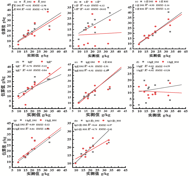
Fig.4 Tested based on different models for model establishment
| [1] | A M F, B R L, A H Z, et al. Variability and determinants of soil organic matter under different land uses and soil types in eastern China[J]. Soil and Tillage Research, 2020: 198. |
| [2] | Marco A. Jiménez-González, Lvarez A M, Carral P, et al. Climate variability in Mediterranean ecosystems is reflected by soil organic matter pyrolytic fingerprint[J]. Geoderma, 2020: 374. |
| [3] | Sergei C, Fu S. Applications of physical methods in estimation of soil biota and soil organic matter[J]. Soil Ecology Letters, 2020:1-11. |
| [4] | 张森, 卢霞, 聂格格, 等. SVM和BP检测滨海湿地土壤有机质[J]光谱学与光谱分析, 2020, 40(2):556-561. |
| ZHANG Sen, LU Xia, NIE Gege, et al. Estimation of Soil Organic Matter in Coastal Wetlands by SVM and BP Based on Hyperspectral Remote Sensing[J]. Spectroscopy and Spectral Analysis, 2020, 40(2):556-561. | |
| [5] | 邹慧敏, 李西灿, 尚璇, 等. 粒子群优化神经网络的土壤有机质高光谱估测[J]. 测绘科学, 2019, 44(5):146-150, 170. |
| ZHOU Huimin, LI Xican, SHANG Xuan, et al. Hyperspectral estimation of soil organic matter based on particle swarm optimization neural network[J]. Science of Surveying and Mapping, 2019, 44(5):146-150, 170. | |
| [6] | 沈强, 张世文, 夏沙沙, 等. 基于支持向量机的土壤有机质高光谱反演[J]. 安徽理工大学学报(自然科学版), 2019, 39(4):39-45. |
| SHEN Qiang, ZHANG Shiwen, XIA Shasha, et al. Hyperspectral Inversion of Soil Organic Matter Based on Support Vector Machine[J]. Journal of Anhui university of science and technology (Natural Science Edition), 2019, 39(4):39-45. | |
| [7] | 宋雪, 张民, 周洪印, 等. 基于土壤优化光谱参数估测太湖地区土壤全氮含量[J]. 农业资源与环境学报, 2020, 37(1):43-50. |
| SONG Xue, ZHANG Ming, ZHOU Hongyin, et al. Estimation of soil total nitrogen content in the Taihu Lake region based on soil regulatory spectral parameters[J]. Journal of Agricultural Resources and Environment, 2020, 37(1):43-50. | |
| [8] |
Shen L, Gao M, Yan J, et al. Hyperspectral Estimation of Soil Organic Matter Content using Different Spectral Preprocessing Techniques and PLSR Method[J]. Remote Sensing, 2020, 12(7):1206.
DOI URL |
| [9] | 王库. 基于地理权重回归模型的土壤有机质空间预测[J]. 土壤通报, 2013, 44(1):21-28. |
| WANG Ku. Spatial Estimation of Soil Organic Matter by Using Geographically Weighted Regression Model[J]. Chinese Journal of Soil Science, 2013, 44(1):21-28. | |
| [10] | 赵慧, 李新国, 靳万贵, 等. 博斯腾湖西岸湖滨绿洲土壤含盐量高光谱估算[J]. 中山大学学报(自然科学版), 2020, 59(4):56-63. |
| ZHAO Hui, LI Xinguo, JIN Wangui, et al. Hyperspectral estimation of soil salt content in lake oasis on the west bank of Bosten lake[J]. Acta Scientiarum Naturalium Universitatis Sunyatseni, 2020, 59(4):56-63. | |
| [11] | 阿提姑·吐尔洪, 李新国, 李志, 等. 新疆博斯腾湖西岸湖滨带土壤剖面重金属分布特征及来源分析[J]. 生态科学, 2019, 38(6):53-59. |
| Atigul Tuerxun, LI Xinguo, LI Zhi, et al. Distribution characteristics and sources of heavy metals in soil profile of lakeside zone on the west bank of Boston lake, Xinjiang[J]. Ecological Science, 2019, 38(6):53-59. | |
| [12] | 牛芳鹏, 李新国, 靳万贵, 等. 博斯腾湖西岸湖滨绿洲土壤盐分特征[J]. 中国土壤与肥料, 2020,(3):8-15. |
| NIU Fanpeng, LI Xinguo, JIN Wangui, et al. Characteristics of soil salinity in the western lakeside oasis of Bosten Lake[J]. Soil and Fertilizer Sciences in China, 2020,(3):8-15. | |
| [13] | 赵丽莉, 盛建东, 武红旗, 等. 博湖县耕地地力评价及其影响因素分析[J]. 新疆农业科学, 2013, 50(10):1954-1960. |
| ZHAO Lili, SHENG Jiandong, WU Hongqi, et al. Evaluation and the Influencing Factors of Farmland Productivity in Bohu County of Bazhou, Xinjiang[J]. Xinjiang Agricultural Sciences, 2013, 50(10):1954-1960. | |
| [14] | Fortheringham A S, Chanrlton M, Brunsdon , et al. The geographically of parameter space: An investigation of spatial nonstationarity[J]. International Journal of Geographical Information Systems, 1996, (10):605-627. |
| [15] | 马勇, 黄智洵. 长江中游城市群绿色发展指数测度及时空演变探析—基于GWR模型[J]. 生态环境学报, 2017, 26(5):794-807. |
| MA Yong, HUANG Zhixun. Study on spatial-temporal evolution and measurement of green development index of urban agglomerations in the middle reaches of Yangtze River—GWR model based[J]. Ecology and Environmental Sciences, 2017, 26(5):794-807. | |
| [16] | 耿甜伟, 陈海, 张行, 等. 基于GWR的陕西省生态系统服务价值时空演变特征及影响因素分析[J]. 自然资源学报, 2020, 35(7):1714-1727. |
|
GENG Tianwei, CHEN Hai, ZHANG Hang, et al. Spatiotemporal evolution of land ecosystem service value and its influencing factors in Shaanxi province based on GWR[J]. Journal of Natural Resources, 2020, 35(7):1714-1727.
DOI URL |
|
| [17] | Cloutis E A. Hyperspectral geological remote sensing: evaluation of analytical techniques[J]. Intl. J. Remote Sens, 1996: 14. |
| [18] |
刘焕军, 张柏, 刘殿伟, 等. 基于反射率模拟模型的黑土有机质含量估测[J]. 光谱学与光谱分析, 2008, 28(12):2947-2950.
PMID |
|
LIU Huanjun, ZHANG Bo, LIU Dianwei, et al. Black Soil Organic Matter Content Prediction Based on Reflectance Simulation Models[J]. Spectroscopy and Spectral Analysis, 2008, 28(12):2947-2950.
PMID |
|
| [19] | 刘焕军, 鲍依临, 徐梦园, 等. 基于SOM和NDVI的黑土区精准管理分区对比[J]. 农业工程学报, 2019, 35(13):177-183. |
| LIU Huanjun, BAO Yilin, XU Mengyuan, et al. Comparison of precision management zoning methods in black soil area based on SOM and NDVI[J]. Transactions of the Chinese Society of Agricultural Engineering (Transactions of the CSAE), 2019, 35(13):177-183. | |
| [20] | 洪永胜, 朱亚星, 苏学平, 等. 高光谱技术联合归一化光谱指数估算土壤有机质含量[J]. 光谱学与光谱分析, 2017, 37(11):3537-3542. |
| HONG Yongsheng, ZHU Yaxing, SU Xueping, et al. Estimation of Soil Organic Matter Content Using Hyperspectral Techniques Combined with Normalized Difference Spectral Index[J]. Spectroscopy and Spectral Analysis, 2017, 37(11):3537-3542. | |
| [21] | 赵明松, 刘斌寅, 卢宏亮, 等. 基于地理加权回归的地形平缓区土壤有机质空间建模[J]. 农业工程学报, 2019, 35(20):102-110. |
| ZHAO Mingsong, LIU Binyin, LU Hongliang, et al. Spatial modeling of soil organic matter over low relief areas based on geographically weighted regression[J]. Transactions of the Chinese Society of Agricultural Engineering (Transactions of the CSAE), 2019, 35(20):102-110. | |
| [22] | 单海斌, 蒋平安, 颜安, 等. 基于高光谱数据的北疆绿洲农田灰漠土有机质反演[J]. 农业资源与环境学报, 2018, 35(3):276-282. |
| SHAN Haibin, JIANG Pingan, YAN An, et al. Inversion of Organic Matter Content in Grey Desert Soil of Northern Xinjiang Oasis Farmland Based on Hyper-spectral Data[J]. Journal of Agricultural Resources and Environment, 2018, 35(3):276-282. | |
| [23] | 叶勤, 姜雪芹, 李西灿, 等. 基于高光谱数据的土壤有机质含量反演模型比较[J]. 农业机械学报, 2017, 48(3):164-172. |
| YE Qin, JIANG Xueqin, LI Xican, et al. Comparison on Inversion Model of Soil Organic Matter Content Based on Hyperspectral Data[J]. Transactions of the Chinese Society for Agricultural Machinery, 2017, 48(3):164-172. | |
| [24] | 高志海, 白黎娜, 王琫瑜, 等. 荒漠化土地土壤有机质含量的实测光谱估测[J]. 林业科学, 2011, 47(6):9-16. |
| GAO Zhihai, BAI Lina, WANG Bengyu, et al. Estimation of Soil Organic Matter Content in Desertified Lands Using Measured Soil Spectral Data[J]. Forestry Science & Technology, 2011, 47(6):9-16. |
| [1] | Aliya Alimu, CONG Xiaohan, XIA Xiaoying, XI Li, WANG Weixia. Characteristics of Soil Nutrient under Different Land Use Patterns [J]. Xinjiang Agricultural Sciences, 2022, 59(4): 925-933. |
| [2] | WANG Zhenguo, MA Yuanyuan, WANG Xina, LIU Shaoquan, GU Chaofeng, JI Qiang. Effects of Biochar Input on Soil Organic Carbon and Maize Growth [J]. Xinjiang Agricultural Sciences, 2022, 59(4): 818-826. |
| [3] | ZHU Zhen, LI Tiansheng, CUI Jing, CHEN Jianhua, SHI Xiaoyan, JIANG Menghao, WANG Haijiang. Study on Estimation of Water Status of Winter Wheat in Different Growth Stages Based on Hyperspectral Imaging [J]. Xinjiang Agricultural Sciences, 2022, 59(3): 521-532. |
| [4] | LI Zhi, SU Wuzheng, LI Xinguo, WANG Yinfang, MAO Donglei, Mamattursun Eziz. Modeling and Verification of Soil Salt Content Based on Hyperspectral Characteristic Parameter Optimization [J]. Xinjiang Agricultural Sciences, 2021, 58(12): 2342-2352. |
| [5] | CHEN Shu-huang;GENG Qing-long;MA Yan-ru;FENG Yao-zu;Karabaev Nurudin;DONG Ju-he;WANG Xin-yong. Analysis of Variations on Soil Organic Matter between Xinjiang and the Kyrgyz Republic [J]. , 2013, 50(9): 1748-1752. |
| Viewed | ||||||
|
Full text |
|
|||||
|
Abstract |
|
|||||