
Xinjiang Agricultural Sciences ›› 2021, Vol. 58 ›› Issue (12): 2342-2352.DOI: 10.6048/j.issn.1001-4330.2021.12.022
• A nimal Husbandry Veterinarian · Agricultural Information • Previous Articles
LI Zhi1( ), SU Wuzheng1, LI Xinguo2,3(), WANG Yinfang1, MAO Donglei2,3, Mamattursun Eziz2,3
Received:2021-04-01
Online:2021-12-20
Published:2021-12-31
Correspondence author:
LI Xinguo
Supported by:
李志1(), 苏武峥1, 李新国2,3(), 王银方1, 毛东雷2,3, 麦麦提吐尔逊·艾则孜2,3
通讯作者:
李新国
作者简介:李志(1992-),男,重庆人,助理研究员,硕士,研究方向为农业遥感与信息技术,(E-mail) lizhi2378@163.com
基金资助:CLC Number:
LI Zhi, SU Wuzheng, LI Xinguo, WANG Yinfang, MAO Donglei, Mamattursun Eziz. Modeling and Verification of Soil Salt Content Based on Hyperspectral Characteristic Parameter Optimization[J]. Xinjiang Agricultural Sciences, 2021, 58(12): 2342-2352.
李志, 苏武峥, 李新国, 王银方, 毛东雷, 麦麦提吐尔逊·艾则孜. 基于高光谱特征参数优选的土壤盐分含量建模及其验证[J]. 新疆农业科学, 2021, 58(12): 2342-2352.
Add to citation manager EndNote|Ris|BibTeX
URL: http://www.xjnykx.com/EN/10.6048/j.issn.1001-4330.2021.12.022
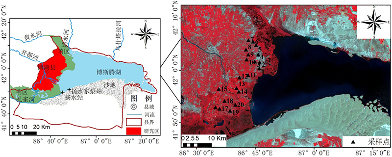
Fig.1 Location of the sampling area and its sample layout

Fig. 2 Statistics of salt content frequency distribution in model set and validation set
| 参数Parameter | 定义Definition |
|---|---|
| Rλ | 在波段λ处的土壤反射光谱 Soil reflectance spectrum at bandλ |
| DSI(i,j) | DSI=Rj-Ri |
| RSI(i,j) | RSI=Rj/Ri |
| NDSI(i,j) | NDSI=(Rj-Ri)/(Rj+Ri) |
Table 1 Definition of parameters
| 参数Parameter | 定义Definition |
|---|---|
| Rλ | 在波段λ处的土壤反射光谱 Soil reflectance spectrum at bandλ |
| DSI(i,j) | DSI=Rj-Ri |
| RSI(i,j) | RSI=Rj/Ri |
| NDSI(i,j) | NDSI=(Rj-Ri)/(Rj+Ri) |
| 参数 Parameter | 简称 Abbreviation | 公式 Formula | 描述 Description | |
|---|---|---|---|---|
| 建模决定系数 Modeling determination factor | $\sum^{N}_{i=1}(x_{i}-\bar{x})(y_{i}-\bar{y})/ \sqrt{\sum^{N}_{i=1}(x_{i}-\bar{x})^{2}+\sum^{N}_{i=1}(y_{i}-\bar{y})^{2}}$ | 当值越接近1,模型越稳定 | ||
| 预测决定系数 Predictive determination coefficient | ||||
| 校正均方根误差 Correct the root mean square error | RMSEC | $\sqrt{\sum^{N}_{i=1}(y_{i}-\bar{x})^{2}/N}$ | 当值越接近0,模型精度越高 | |
| 验证均方根误差 Verify the root mean square error | RMSEV | |||
| 相对分析误差 Relative prediction deviation | RPD | 0~1.4,差;1.4~2.0,可用;大于2.0,好 | ||
Table 2 Parameters of model accuracy
| 参数 Parameter | 简称 Abbreviation | 公式 Formula | 描述 Description | |
|---|---|---|---|---|
| 建模决定系数 Modeling determination factor | $\sum^{N}_{i=1}(x_{i}-\bar{x})(y_{i}-\bar{y})/ \sqrt{\sum^{N}_{i=1}(x_{i}-\bar{x})^{2}+\sum^{N}_{i=1}(y_{i}-\bar{y})^{2}}$ | 当值越接近1,模型越稳定 | ||
| 预测决定系数 Predictive determination coefficient | ||||
| 校正均方根误差 Correct the root mean square error | RMSEC | $\sqrt{\sum^{N}_{i=1}(y_{i}-\bar{x})^{2}/N}$ | 当值越接近0,模型精度越高 | |
| 验证均方根误差 Verify the root mean square error | RMSEV | |||
| 相对分析误差 Relative prediction deviation | RPD | 0~1.4,差;1.4~2.0,可用;大于2.0,好 | ||

Fig.3 Distribution and variation of salinity in soil profile
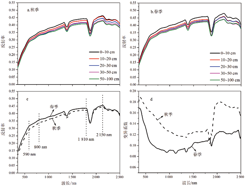
Fig.4 Characteristics of spectral reflectance curves of soil profiles
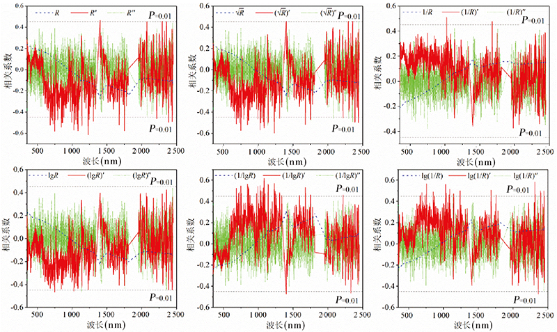
Fig.5 One-dimensional correlation analysis of soil salinity content and spectral reflectance of different transformed forms
| 光谱变换 Spectrum transform | 极显著相关系数绝对值超出的数量 The number of extremely significant correlation coefficients exceeding the absolute value (|r|≥0.45,P<0.01) | 相关系数 绝对值的最值 (|r|max) | 相关系数绝对值((|r|)的 最值波段位置 The band position of|r|max |
|---|---|---|---|
| R | 0 | 0.27 | 1 406 nm |
| R' | 46 | 0.62 | 1 230 nm |
| ( | 35 | 0.60 | 1 230 nm |
| (1/lgR)' | 53 | 0.63 | 1 083 nm |
| lg(1/R)' | 18 | 0.58 | 2 307 nm |
Table 2 Statistical analysis of characteristic bands of soil salinity under different spectral transformation forms
| 光谱变换 Spectrum transform | 极显著相关系数绝对值超出的数量 The number of extremely significant correlation coefficients exceeding the absolute value (|r|≥0.45,P<0.01) | 相关系数 绝对值的最值 (|r|max) | 相关系数绝对值((|r|)的 最值波段位置 The band position of|r|max |
|---|---|---|---|
| R | 0 | 0.27 | 1 406 nm |
| R' | 46 | 0.62 | 1 230 nm |
| ( | 35 | 0.60 | 1 230 nm |
| (1/lgR)' | 53 | 0.63 | 1 083 nm |
| lg(1/R)' | 18 | 0.58 | 2 307 nm |

Fig. 6 R2 matrix of spectral index DSI, RSI, NDSI and soil salinity
| 光谱指数 Spectral indices | R2超出的光谱指数数量(R2≥0.4,P<0.01) The number of spectral indices R2 exceeds 0.4 | R2最大值 | R2最大值的对应波段组合 The band position of |
|---|---|---|---|
| 差值指数(DSI) Differential spectral index | 32 | 0.54 | R1 780-R1 765 |
| 比值指数(RSI) The ratio of spectral index | 25 | 0.48 | R1 785/R1 756 |
| 归一化指数(NDSI) Normalized spectral index | 38 | 0.57 | (R1 780-R1 742)/(R1 780+R1 742) |
Table 3 Soil salt characteristic band combination based on spectral index
| 光谱指数 Spectral indices | R2超出的光谱指数数量(R2≥0.4,P<0.01) The number of spectral indices R2 exceeds 0.4 | R2最大值 | R2最大值的对应波段组合 The band position of |
|---|---|---|---|
| 差值指数(DSI) Differential spectral index | 32 | 0.54 | R1 780-R1 765 |
| 比值指数(RSI) The ratio of spectral index | 25 | 0.48 | R1 785/R1 756 |
| 归一化指数(NDSI) Normalized spectral index | 38 | 0.57 | (R1 780-R1 742)/(R1 780+R1 742) |

Fig.7 Screening the best model spectral band based on the VIP algorithm
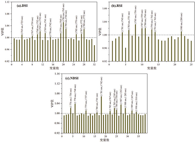
Fig. 8 Screening the best model spectral index based on VIP algorithm
| 光谱特征参数 Spectral characteristic parameter | 自变量个数 Number of independent variables | 建模集Modeling set | 验证集Validation set | ||||
|---|---|---|---|---|---|---|---|
| RMSEC | RMSEV | RPD | |||||
| R' | 15 | 0.78 | 0.74 | 0.73 | 0.79 | 1.80 | |
| ( | 8 | 0.74 | 0.79 | 0.66 | 0.82 | 1.68 | |
| (1/lgR)' | 16 | 0.82 | 0.61 | 0.77 | 0.69 | 2.01 | |
| [lg(1/R)]' | 7 | 0.62 | 0.83 | 0.57 | 0.92 | 1.51 | |
| DSI | 12 | 0.81 | 0.51 | 0.72 | 0.73 | 1.88 | |
| RSI | 8 | 0.74 | 0.75 | 0.63 | 0.95 | 1.62 | |
| NDSI | 12 | 0.86 | 0.46 | 0.77 | 0.64 | 2.11 | |
Table 4 Prediction results of soil salt content by PLSR model
| 光谱特征参数 Spectral characteristic parameter | 自变量个数 Number of independent variables | 建模集Modeling set | 验证集Validation set | ||||
|---|---|---|---|---|---|---|---|
| RMSEC | RMSEV | RPD | |||||
| R' | 15 | 0.78 | 0.74 | 0.73 | 0.79 | 1.80 | |
| ( | 8 | 0.74 | 0.79 | 0.66 | 0.82 | 1.68 | |
| (1/lgR)' | 16 | 0.82 | 0.61 | 0.77 | 0.69 | 2.01 | |
| [lg(1/R)]' | 7 | 0.62 | 0.83 | 0.57 | 0.92 | 1.51 | |
| DSI | 12 | 0.81 | 0.51 | 0.72 | 0.73 | 1.88 | |
| RSI | 8 | 0.74 | 0.75 | 0.63 | 0.95 | 1.62 | |
| NDSI | 12 | 0.86 | 0.46 | 0.77 | 0.64 | 2.11 | |
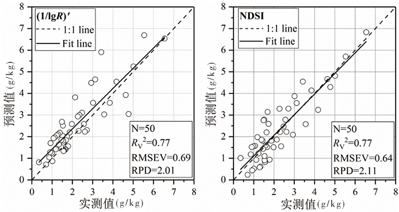
Fig. 9 Verification results based on one-dimensional and two-dimensional optimal response parameterspectral estimation models
| [1] | 祁亚琴, 张显峰, 张立福, 等. 基于高光谱数据的农田土壤养分含量估测模型研究[J]. 新疆农业科学, 2018,55(3):490-495. |
| QI Yaqin, ZHANG Xianfeng, ZHANG Lifu, et al. Research on soil nutrient content estimated model by hyperspectral remote sensing data[J]. Xinjiang Agricultural Sciences, 2018,55(3):490-495. | |
| [2] | 郭全恩, 王益权, 马忠明, 等. 植被类型对土壤剖面盐分离子迁移与累积的影像[J]. 中国农业科学, 2011,44(13):2711-2720. |
| GUO Quanen, WANG Yiquan, MA Zhongming, et al. Effect of vegetation types on soil salt ions transfer and accumulation in soil profile[J]. Scientia Agricultura Sinica, 2011,44(13):2711-2720. | |
| [3] | 徐明星. 江苏沿海滩涂地区典型剖面土壤性质演化及其高光谱响应研究[D]. 南京:南京大学, 2011. |
| XU Mingxing. Evolution of soil basic properties and its hyperspectral response in typical profiles of coastal tidal region of Jiangsu province, China[D]. Nanjing: Nanjing University, 2011. | |
| [4] | 童庆禧, 张兵, 郑兰芬. 高光谱遥感—原理、技术、应用[M]. 北京: 高等教育出版社, 2006. |
| TONG Qingxi, ZHANG Bing, ZHENG Lanfen. Hyperspectral Remote Sensing-Principles, Techniques, Applications [M]. Beijing: Higher Education Press, 2006. | |
| [5] | 翁永玲, 宫鹏. 土壤盐渍化遥感应用研究进展[J]. 地理科学, 2006,26(3):369-375. |
| WENG Yongling, GONG Peng. A review on remote sensing technique for salt-affected soils[J]. Scientia Geographica Sinica, 2006,26(3):369-375. | |
| [6] | 洪永胜, 朱亚星, 苏学平, 等. 高光谱技术联合归一化光谱指数估算土壤有机质含量[J]. 光谱学与光谱分析, 2017,37(11):3537-3542. |
| HONG Yongsheng, ZHUYaxing, SU Xueping, et al. Estimation of soil organic matter content using hyperspectral techniques combined with normalized difference spectral index[J]. Spectroscopy and Spectral Analysis, 2017,37(11):3537-3542. | |
| [7] | 李焱, 王让会, 管延龙, 等. 基于高光谱反射特性的土壤全氮含量预测分析[J]. 遥感技术与应用, 2017,32(1):173-179. |
| LI Yan, WANG Ranghui, GUAN Yanlong, et al. Prediction analysis of soil total nitrogen content based on hyperspectral[J]. Remote Sensing Technology and Application, 2017,32(1):173-179. | |
| [8] | Chernousenko G I, Kalinina N V, Khitrov N B, et al. Quantification of the areas of saline and solonetzic soils in the Ural Federal Region of the Russian federation[J]. Eurasian Soil Science, 2011,44(4):367-379. |
| [9] | Mashimbye Z E, Cho M A, Nell J P, et al. Model-based integrated methods for quantitative estimation of soil salinity from hyperspectral remote sensing data: A case studyof selected South African soils[J]. Pedosphere, 2012,22(5):640-649. |
| [10] | Kumar S, Gautam G, Saha S K. Hyperspectral remote sensing data derived spectral indicesin characterizing salt-affected soils: a case study of Indo-Gangetic plains of India[J]. Environmental Earth Sciences, 2015,73(7):3299-3308. |
| [11] | 彭杰, 迟春明, 向红英, 等. 基于连续统去除法的土壤盐分含量反演研究[J]. 土壤学报, 2014,51(3):459-469. |
| PENG Jie, CHI Chunming, XIANG Hongying, et al. Inversion of soil salt content based on continuum-removal method[J]. Acta Pedologica Sinica, 2014,51(3):459-469. | |
| [12] | 张贤龙, 张飞, 张海威, 等. 基于光谱变换的高光谱指数土壤盐分反演模型优选[J]. 农业工程学报, 2018,34(1):110-117. |
| ZHANG Xianlong, ZHANG Fei, ZHANG Haiwei, et al. Optimization of soil salt inversion model based on spectral transformation from hyperspectral index[J]. Transactions of the Chinese Society of Agricultural Engineering, 2018,34(1):110-117. | |
| [13] | 王宁, 熊黑钢, 马利芳, 等. 新疆有无人为干扰下土壤盐分估算的比较[J]. 干旱区研究, 2019,36(2):323-330. |
| WANG Ning, XIONG Heigang, MA Lifang, et al. Estimation and comparison of soil salinityunder different intensities of human disturbance in Xinjiang[J]. Arid Zone Research, 2019,36(2):323-330. | |
| [14] | 翁永玲, 戚浩平, 方洪宾, 等. 基于PLSR方法的青海茶卡-共和盆地土壤盐分高光谱遥感反演[J]. 土壤学报, 2010,47(6):1255-1263. |
| WENG Yongling, QI Haoping, FANG Hongbin, et al. PLSR-based hyperspectral remote sensing retrieval of soil salinity of Chaka-Gonghe Basin in Qinghai province[J]. Acta Pedologica Sinica, 2010,47(6):1255-1263. | |
| [15] | 蒲智, 于瑞德, 尹昌应, 等. 干旱区典型盐碱土壤含盐量估算的最佳高光谱指数研究[J]. 水土保持通报, 2012,32(6):129-133. |
| PU Zhi, YU Ruide, YIN Changying, et al. Optimal hyperspectral indices for soil salt content estimation on typical saline soil in arid areas[J]. Bulletin of Soil and Water Conservation, 2012,32(6):129-133. | |
| [16] | 朱赟, 申广荣, 项巧巧, 等. 基于不同光谱变换的土壤盐含量光谱特征分析[J]. 土壤通报, 2017,48(3):560-568. |
| ZHU Yun, SHEN Guangrong, XIANG Qiaoqiao, et al. Spectral characteristics of soil salinity based on different pre-processing methods[J]. Chinese Journal of Soil Science, 2017,48(3):560-568. | |
| [17] | 李新国, 李和平, 任云霞, 等. 开都河流域下游绿洲土壤盐渍化特征及其光谱分析[J]. 土壤通报, 2012,43(1):166-170. |
| LI Xinguo, LI Heping, REN Yunxia, et al. Analysis on the characteristics of the oasis soil salinization and soil spectrum in the lower reaches of Kaidu River Basin, Xinjiang[J]. Chinese Journal of Soil Science, 2012,43(1):166-170. | |
| [18] | 李志, 李新国, 毛东雷, 等. 博斯腾湖西岸湖滨带不同植被类型土壤剖面盐分特征分析[J]. 西北农业学报, 2018,27(2):260-268. |
| LI Zhi, LI Xinguo, MAO Donglei, et al. Analysis of salinity characteristics of different vegetation types in soil profile in westernside of Bosten Lake of Xinjiang[J]. Acta Agriculturae Boreali-Occidentalis Sinica, 2018,27(2):260-268. | |
| [19] | 李和平, 樊自立, 程心俊, 等. 采用土地资源利用限制因素指标进行土壤基层分类(以新疆干旱土纲基层分类为例)[J]. 干旱区研究, 2000,17(2):28-33. |
| LI Heping, FAN Zili, CHENG Xinjun, et al. Study on basic soil classification form limited factor index of land resources development—an example from basic categories of arid sols order[J]. Arid Zone Research, 2000,17(2):28-33. | |
| [20] | 林鹏达, 佟志军, 张继权, 等. 基于CWT的黑土有机质含量野外高光谱反演模型[J]. 水土保持研究, 2018,25(2):46-52,57. |
| LIN Pengda, TONG Zhijun, ZHANG Jiquan, et al. Inversion of black soil organic matter content with field hyperspectral reflectance based on continuous wavelet transformation[J]. Soil and Water Conservation Research, 2018,25(2):46-52,57. | |
| [21] | 鲍士旦. 土壤农化分析[M]. 北京: 中国农业出版社, 2000. |
| BAO Shidan. Analysis of Soil Agrochemicals [M]. Beijing: China Agriculture Press, 2000. | |
| [22] | 陈弈云, 赵瑞瑛, 齐天赐, 等. 结合光谱变换和Kennard-Stone算法的水稻土全氮光谱估算模型校正集构建策略研究[J]. 光谱学与光谱分析, 2017,37(7):2133-2139. |
| CHEN Yiyun, ZHAO Ruiying, QI Tianci, et al. Constructingrepresentative calibration dataset based onspectral transformation and Kennard-Stone algorithmfor VNIR modeling of soil total nitrogen in paddy soil[J]. Spectroscopy and Spectral Analysis, 2017,37(7):2133-2139. | |
| [23] | 章文龙, 曾从盛, 高灯州, 等. 闽江河口湿地土壤全磷高光谱遥感估算[J]. 生态学报, 2015,35(24):8085-8093. |
| ZHANG Wenlong, ZENG Congsheng, GAO Dengzhou, et al. Estimating the soil total phosphorus content based on hyperspectral remote sensing data in the Min River estuarine wetland[J]. Acta Ecologica Sinica, 2015,35(24):8085-8093. | |
| [24] | 徐庆, 马驿, 蒋琦, 等. 水稻叶片含水量的高光谱遥感估算[J]. 遥感信息, 2018,33(5):1-8. |
| XU Qing, MA Yi, JIANG Qi, et al. Estimation of rice leafwater content based on hyperspectral remote sensing[J]. Remote Sensing Information, 2018,33(5):1-8. | |
| [25] | 尼加提·卡斯木, 茹克亚·萨吾提, 师庆东, 等. 基于优化光谱指数的土壤有机质含量估算[J]. 农业机械学报, 2018,49(11):155-163. |
| Nijiati Kasimu, Rukeya Sawuti, SHI Qingdong, et al. Estimation of soil organic matter content based on optimized spectral index[J]. Transactions of the Chinese Society of Agricultural Machinery, 2018,49(11):155-163. |
| [1] | ZHU Zhu, ZHANG Xuxian, WANG Shichang, WEN Hao, CAI Guixiang. Effects of Insertion Subsurface Drip Irrigation on Soil Infiltration and Distribution of Water and Salt [J]. Xinjiang Agricultural Sciences, 2023, 60(2): 440-447. |
| [2] | ZHU Zhen, LI Tiansheng, CUI Jing, CHEN Jianhua, SHI Xiaoyan, JIANG Menghao, WANG Haijiang. Study on Estimation of Water Status of Winter Wheat in Different Growth Stages Based on Hyperspectral Imaging [J]. Xinjiang Agricultural Sciences, 2022, 59(3): 521-532. |
| [3] | Hazirtiali Keyim, LI Xinguo, ZHAO Hui, Mamattursun Eziz. Hyperspectral Estimation of Surface Soil Organic Matter Content in the Oasis Based on Geographically Weighted Regression Model [J]. Xinjiang Agricultural Sciences, 2022, 59(1): 223-230. |
| [4] | Adil Hekim, Muhtar Zari, Roxangul Mahmut, WANG Baoqing. Comparison on Characteristic Parameters of Photosynthesis Diurnal Variation and Light Response Curve of 5 Grape Cultivars under ‘V’ Shaped Casserole [J]. Xinjiang Agricultural Sciences, 2022, 59(1): 105-112. |
| [5] | LI Jianfeng, FAN Zheru, ZHANG Yueqiang, WANG Zhong, GAO Xin, SHI Jia, ZHANG Hongzhi, WANG Lihong, ZHAO Qi. Study on Dynamic Difference of Xinjiang Spring Wheat at the Grain Filling Stage [J]. Xinjiang Agricultural Sciences, 2021, 58(3): 393-400. |
| [6] | Hudan Tumaerbai, Mulideer Tuohuojia, ZHU Zhu. Experimental Study on Longitudinal Dispersion Coefficient of Typical Soil in Northern Xinjiang [J]. Xinjiang Agricultural Sciences, 2021, 58(1): 151-158. |
| [7] | DING Bangxin, LIU Xueyan, BAI Yungang, LIU Hongbo, DING Ping, XIAO Jun. Spatial Variation of Soil Salinity in the Typical Oasis Irrigation Area of the Lower Reaches of Tarim River [J]. Xinjiang Agricultural Sciences, 2020, 57(2): 264-273. |
| [8] | YU Xiao-e, OU Yuan, XU Ye-yong, HU Hai-fang, WANG Bao-qing, QI Cheng. Study on Photosynthesis Response Characteristics in Different Parts of Walnut Main Branch Ring after Circumferential Peeling [J]. Xinjiang Agricultural Sciences, 2019, 56(12): 2282-2288. |
| [9] | ZHU Zhen, WANG Hai-jiang, SU Ting, SHI Xiao-yan, SONG Jiang-hui, ZHU Yong-qi, ZHENG QI. Research on Salt Discharge Effect of Different Buried Deep Pipes in Salinized Farmland [J]. Xinjiang Agricultural Sciences, 2018, 55(8): 1523-1533. |
| [10] | ZHANG Shao-min, BAI Deng-sha, LIU Sheng-lin, ZHOU Guang-wei, FENG Gu. Effects of Land Reclamation Years on the Distribution Characteristics of Soil Salinity, Fertility and Nitrate Nitrogen under Mulching Drip Irrigation [J]. Xinjiang Agricultural Sciences, 2018, 55(11): 2060-2068. |
| [11] | HUANG Jian,QI tong,WANG Zhi-guo,WANG Qing-liang,FU Yan-bo,MENG A-jing. Response of Saliconia-Europea L. Chlorophyll Fluorescence System to Nitrogen in Salt Environment [J]. Xinjiang Agricultural Sciences, 2018, 55(10): 1936-1942. |
| [12] | SHAN Na-na;LAI Bo;YANG Zhi-ying;SHAO Hua-wei;ZHA Zhi-hao. Study on Changes of Soil Salinity after Planting Halophyte in Northwest of Junggar Basin [J]. , 2016, 53(12): 2314-2320. |
| [13] | HUANG Jian;FENG Yao-zhu;GENG Qing-long;FU Yan-bo. Characteristics of Nutrient in Jujube-grain Intercropping under Different Cultivating Years [J]. , 2015, 52(7): 1316-1321. |
| [14] | Mahmut Ablat;Muhtar Zari;Qiman Yunus. Response of Growth Parameters and Photosynthetic Characteristics of Elaeagnus oxycarpa Schlecht.to Different Drought Stresses [J]. , 2015, 52(5): 862-867. |
| [15] | CAO Jing;YANG Xiao-dong;L(U) Guang-hui;WANG Ting-quan;ZHAO Xiao-ying;LIU Wei;LIU Zhi-dong. Effect of Soil Salinity on the Photosynthesis and Leaf Functional Traits of Nitraria [J]. , 2015, 52(11): 2065-2075. |
| Viewed | ||||||
|
Full text |
|
|||||
|
Abstract |
|
|||||