
Xinjiang Agricultural Sciences ›› 2024, Vol. 61 ›› Issue (11): 2807-2814.DOI: 10.6048/j.issn.1001-4330.2024.11.022
• Prataculture • Previous Articles Next Articles
ZHAO Haonan1( ), MA Haiyan2,3, Asiya Manlike2,3, TIAN Cong2,3, XU Jun2,3, PAN Jing1, SUN Zongjiu1, ZHENG Fengling2,3()
Received:2024-03-11
Online:2024-11-20
Published:2025-01-08
Correspondence author:
ZHENG Fengling
Supported by:
赵昊楠1(), 马海燕2,3, 阿斯娅·曼力克2,3, 田聪2,3, 徐俊2,3, 潘竟1, 孙宗玖1, 郑逢令2,3()
通讯作者:
郑逢令
作者简介:赵昊楠(1999-),男,河北张家口人,硕士研究生,研究方向为植被遥感和空间信息技术,(E-mail)zhn113355@gmail.com
基金资助:CLC Number:
ZHAO Haonan, MA Haiyan, Asiya Manlike, TIAN Cong, XU Jun, PAN Jing, SUN Zongjiu, ZHENG Fengling. Crop remote sensing classification study in Qitai County based on deep learning and Google earth engine (GEE)[J]. Xinjiang Agricultural Sciences, 2024, 61(11): 2807-2814.
赵昊楠, 马海燕, 阿斯娅·曼力克, 田聪, 徐俊, 潘竟, 孙宗玖, 郑逢令. 基于深度学习和GEE的作物遥感分类[J]. 新疆农业科学, 2024, 61(11): 2807-2814.
Add to citation manager EndNote|Ris|BibTeX
URL: https://www.xjnykx.com/EN/10.6048/j.issn.1001-4330.2024.11.022
| 数据源 The data source | 波段数 Band | 空间 分辨率 Spatial resolution | 重访周 期日 Revisit cycle (d) |
|---|---|---|---|
| Sentinel-1 | VV | 10 m | 12 |
| VH | 10 m | ||
| Sentinel-2 | B1(Aerosols) | 60 m | 10 |
| B2(Blue) | 10 m | ||
| B3(Green) | 10 m | ||
| B4(Red) | 10 m | ||
| B5(Red Edge 1) | 20 m | ||
| B6(Red Edge 2) | 20 m | ||
| B7(Red Edge 3) | 20 m | ||
| B8(NIR) | 10 m | ||
| B8A(Red Edge 4 ) | 20 m | ||
| B9(Water vapor) | 60 m | ||
| B10(Cirrus) | 60 m | ||
| B11(短波红外) | 20 m | ||
| B12(短波红外) | 20 m |
Tab.1 Remote Sensing Image Parameters
| 数据源 The data source | 波段数 Band | 空间 分辨率 Spatial resolution | 重访周 期日 Revisit cycle (d) |
|---|---|---|---|
| Sentinel-1 | VV | 10 m | 12 |
| VH | 10 m | ||
| Sentinel-2 | B1(Aerosols) | 60 m | 10 |
| B2(Blue) | 10 m | ||
| B3(Green) | 10 m | ||
| B4(Red) | 10 m | ||
| B5(Red Edge 1) | 20 m | ||
| B6(Red Edge 2) | 20 m | ||
| B7(Red Edge 3) | 20 m | ||
| B8(NIR) | 10 m | ||
| B8A(Red Edge 4 ) | 20 m | ||
| B9(Water vapor) | 60 m | ||
| B10(Cirrus) | 60 m | ||
| B11(短波红外) | 20 m | ||
| B12(短波红外) | 20 m |
| 植被指数 Vegetation indexes | 计算公式 Calculation formula |
|---|---|
| NDVI | (B8-B4)/(B8+B4) |
| NDVIRE1 | (B8A-B5)/(B8A+B5) |
| NDVIRE2 | (B8A-B6)/(B8A+B6) |
| NDVIRE3 | (B8A-B6)/(B8A+B7) |
Tab.2 Vegetation Index Calculation Methods
| 植被指数 Vegetation indexes | 计算公式 Calculation formula |
|---|---|
| NDVI | (B8-B4)/(B8+B4) |
| NDVIRE1 | (B8A-B5)/(B8A+B5) |
| NDVIRE2 | (B8A-B6)/(B8A+B6) |
| NDVIRE3 | (B8A-B6)/(B8A+B7) |
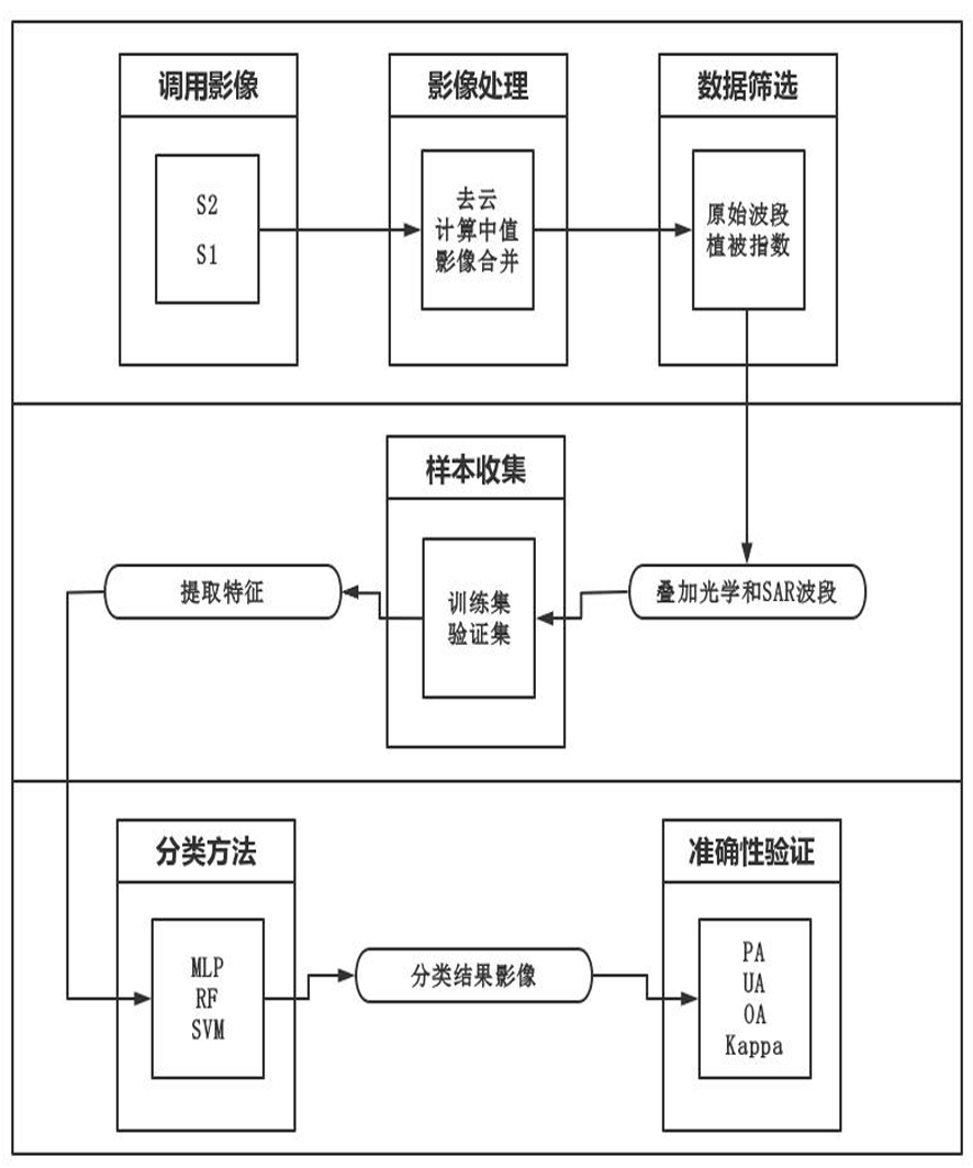
Fig.1 Research Methodology
| 项目 Items | 5 000Epochs | 10 000Epochs | ||
|---|---|---|---|---|
| 神经元个数 Number of neurons | 总体精度 Overall accuracy | 神经元个数 Number of neurons | 总体精度 Overall accuracy | |
| 三个隐藏层 Three hidden layers | 64、32、16 | 0.909 | 64、32、16 | 0.934 |
| 128、64、32 | 0.913 | 128、64、32 | 0.946 | |
| 256、128、64 | 0.925 | 256、128、64 | 0.941 | |
| 四个隐藏层 Four hidden layers | 128、64、32、16 | 0.929 | 128、64、32、16 | 0.938 |
| 256、128、64、32 | 0.931 | 256、128、64、32 | 0.940 | |
| 512、256、128、64 | 0.933 | 512、256、128、64 | 0.943 | |
Tab.3 Overall Accuracy Comparison of Deep Learning under Different Parameters
| 项目 Items | 5 000Epochs | 10 000Epochs | ||
|---|---|---|---|---|
| 神经元个数 Number of neurons | 总体精度 Overall accuracy | 神经元个数 Number of neurons | 总体精度 Overall accuracy | |
| 三个隐藏层 Three hidden layers | 64、32、16 | 0.909 | 64、32、16 | 0.934 |
| 128、64、32 | 0.913 | 128、64、32 | 0.946 | |
| 256、128、64 | 0.925 | 256、128、64 | 0.941 | |
| 四个隐藏层 Four hidden layers | 128、64、32、16 | 0.929 | 128、64、32、16 | 0.938 |
| 256、128、64、32 | 0.931 | 256、128、64、32 | 0.940 | |
| 512、256、128、64 | 0.933 | 512、256、128、64 | 0.943 | |
| 分类算法 Classification algorithm | Overall Accuracy | Kappa |
|---|---|---|
| MLP | 0.946 | 0.941 |
| RF | 0.911 | 0.898 |
| SVM | 0.842 | 0.819 |
Tab.4 Accuracy of different classification algorithms
| 分类算法 Classification algorithm | Overall Accuracy | Kappa |
|---|---|---|
| MLP | 0.946 | 0.941 |
| RF | 0.911 | 0.898 |
| SVM | 0.842 | 0.819 |
| 作物种类 Crop types | MLP | RF | SVM | |||
|---|---|---|---|---|---|---|
| UA | PA | UA | PA | UA | PA | |
| 小麦 Wheat | 0.895 | 0.921 | 0.793 | 0.890 | 0.591 | 0.753 |
| 玉米 Corn | 0.946 | 0.934 | 0.908 | 0.899 | 0.851 | 0.869 |
| 甜菜 Beet | 0.963 | 0.985 | 0.955 | 0.977 | 0.933 | 0.966 |
| 西瓜 Watermelon | 0.954 | 0.980 | 0.929 | 0.975 | 0.811 | 0.951 |
| 其他作物 Other crops | 0.901 | 0.753 | 0.833 | 0.595 | 0.698 | 0.440 |
Tab.5 Accuracy Comparison of Different Crops under Three Algorithms
| 作物种类 Crop types | MLP | RF | SVM | |||
|---|---|---|---|---|---|---|
| UA | PA | UA | PA | UA | PA | |
| 小麦 Wheat | 0.895 | 0.921 | 0.793 | 0.890 | 0.591 | 0.753 |
| 玉米 Corn | 0.946 | 0.934 | 0.908 | 0.899 | 0.851 | 0.869 |
| 甜菜 Beet | 0.963 | 0.985 | 0.955 | 0.977 | 0.933 | 0.966 |
| 西瓜 Watermelon | 0.954 | 0.980 | 0.929 | 0.975 | 0.811 | 0.951 |
| 其他作物 Other crops | 0.901 | 0.753 | 0.833 | 0.595 | 0.698 | 0.440 |
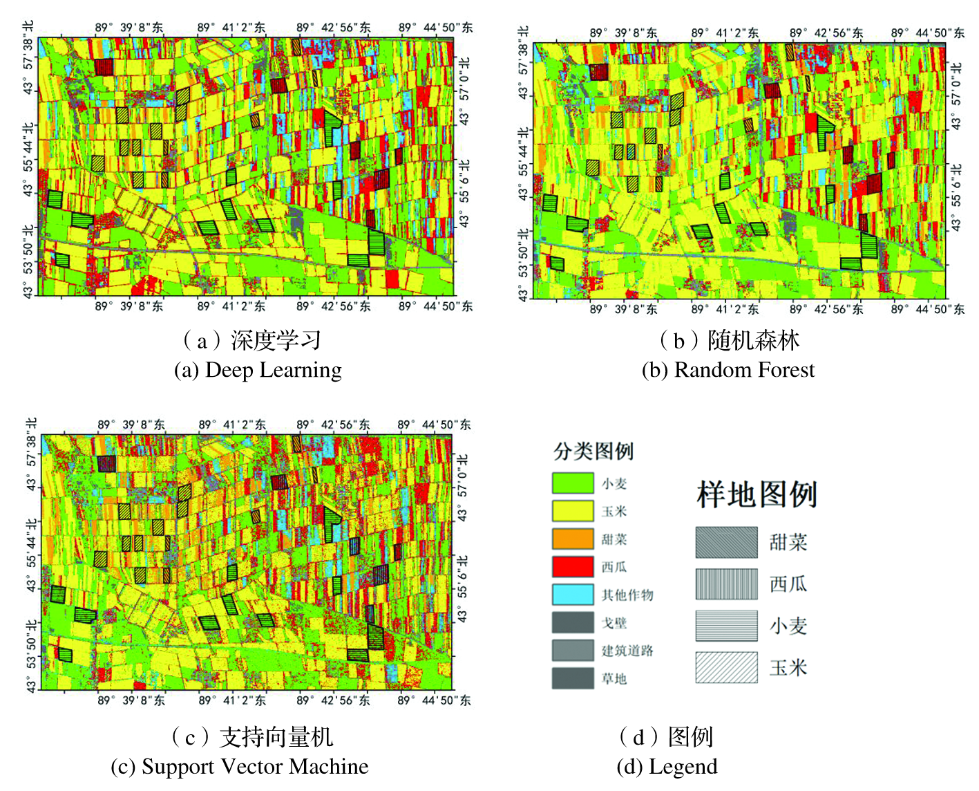
Fig.2 Classification Results of Three Algorithms
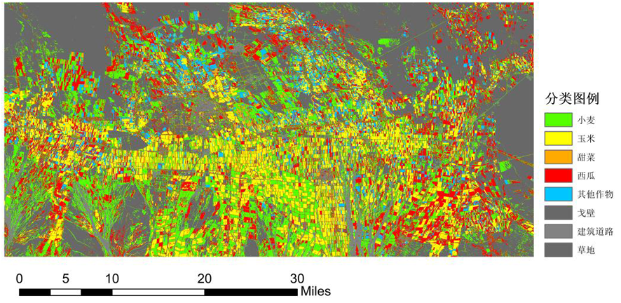
Fig.3 Deep Learning Classification Results
| 小麦 Wheat | 玉米 Corn | 甜菜 Beet | 西瓜 Watermelon | 其他作物 Other crops | 戈壁 Gobi | 建筑道路 Building and roads | 草地 Grassland | |
|---|---|---|---|---|---|---|---|---|
| 小麦Wheat | 257 | 0 | 0 | 0 | 4 | 6 | 6 | 6 |
| 玉米Corn | 2 | 228 | 0 | 2 | 11 | 1 | 0 | 0 |
| 甜菜Beet | 0 | 0 | 259 | 2 | 1 | 0 | 0 | 1 |
| 西瓜Watermelon | 0 | 0 | 0 | 247 | 5 | 0 | 0 | 0 |
| 其他作物Other crops | 28 | 13 | 10 | 6 | 201 | 4 | 1 | 4 |
| 戈壁Gobi | 0 | 0 | 0 | 2 | 0 | 243 | 6 | 1 |
| 建筑道路 Building and roads | 0 | 0 | 0 | 0 | 0 | 1 | 247 | 0 |
| 草地Grassland | 0 | 0 | 0 | 0 | 1 | 0 | 0 | 243 |
Tab.6 Confusion Matrix Results of Deep Learning Classification
| 小麦 Wheat | 玉米 Corn | 甜菜 Beet | 西瓜 Watermelon | 其他作物 Other crops | 戈壁 Gobi | 建筑道路 Building and roads | 草地 Grassland | |
|---|---|---|---|---|---|---|---|---|
| 小麦Wheat | 257 | 0 | 0 | 0 | 4 | 6 | 6 | 6 |
| 玉米Corn | 2 | 228 | 0 | 2 | 11 | 1 | 0 | 0 |
| 甜菜Beet | 0 | 0 | 259 | 2 | 1 | 0 | 0 | 1 |
| 西瓜Watermelon | 0 | 0 | 0 | 247 | 5 | 0 | 0 | 0 |
| 其他作物Other crops | 28 | 13 | 10 | 6 | 201 | 4 | 1 | 4 |
| 戈壁Gobi | 0 | 0 | 0 | 2 | 0 | 243 | 6 | 1 |
| 建筑道路 Building and roads | 0 | 0 | 0 | 0 | 0 | 1 | 247 | 0 |
| 草地Grassland | 0 | 0 | 0 | 0 | 1 | 0 | 0 | 243 |
| [1] | 王爱芳, 张运, 黄静, 等. 作物遥感分类研究进展[J]. 测绘与空间地理信息, 2021, 44(10): 80-83, 88. |
| WANG Aifang, ZHANG Yun, HUANG Jing, et al. Recent progresses in research of crop classification by using remote sensing[J]. Geomatics & Spatial Information Technology, 2021, 44(10): 80-83, 88. | |
| [2] | 赵红伟, 陈仲新, 刘佳. 深度学习方法在作物遥感分类中的应用和挑战[J]. 中国农业资源与区划, 2020, 41(2): 35-49. |
| ZHAO Hongwei, CHEN Zhongxin, LIU Jia. Deep learning for crop classification of remote sensing data: applications and challenges[J]. Chinese Journal of Agricultural Resources and Regional Planning, 2020, 41(2): 35-49. | |
| [3] | Onojeghuo A O, Blackburn G A, Wang Q M, et al. Mapping paddy rice fields by applying machine learning algorithms to multi-temporal Sentinel-1A and Landsat data[J]. International Journal of Remote Sensing, 2018, 39(4): 1042-1067. |
| [4] | Lin Z X, Zhong R H, Xiong X G, et al. Large-scale rice mapping using multi-task spatiotemporal deep learning and sentinel-1 SAR time series[J]. Remote Sensing, 2022, 14(3): 699. |
| [5] | 张乾坤, 蒙继华, 任超. 构建地块二维表征及CNN模型的作物遥感分类[J]. 遥感学报, 2022, 26(7): 1437-1449. |
| ZHANG Qiankun, MENG Jihua, REN Chao. Crop classification based on two-dimensional representation and CNN model from remote sensing[J]. National Remote Sensing Bulletin, 2022, 26(7): 1437-1449. | |
| [6] |
黄翀, 侯相君. 基于Bi-LSTM模型的时间序列遥感作物分类研究[J]. 中国农业科学, 2022, 55(21): 4144-4157.
DOI |
|
HUANG Chong, HOU Xiangjun. Crop classification with time series remote sensing based on Bi-LSTM model[J]. Scientia Agricultura Sinica, 2022, 55(21): 4144-4157.
DOI |
|
| [7] | Zhong L H, Gong P, Biging G S. Efficient corn and soybean mapping with temporal extendability: a multi-year experiment using Landsat imagery[J]. Remote Sensing of Environment, 2014, 140: 1-13. |
| [8] |
Luo C, Liu H J, Lu L, et al. Monthly composites from Sentinel-1 and Sentinel-2 images for regional major crop mapping with Google Earth Engine[J]. Journal of Integrative Agriculture, 2021, 20(7): 1944-1957.
DOI |
| [9] | Wang D, Liu C A, Zeng Y, et al. Dryland crop classification combining multitype features and multitemporal quad-polarimetric RADARSAT-2 imagery in Hebei Plain, China[J]. Sensors, 2021, 21(2): 332. |
| [10] | Kang Y P, Meng Q Y, Liu M, et al. Crop classification based on red edge features analysis of GF-6 WFV data[J]. Sensors, 2021, 21(13): 4328. |
| [11] | 常布辉, 王军涛, 罗玉丽, 等. 河套灌区沈乌灌域GF-1/WFV遥感耕地提取[J]. 农业工程学报, 2017, 33(23): 188-195. |
| CHANG Buhui, WANG Juntao, LUO Yuli, et al. Cultivated land extraction based on GF-1/WFV remote sensing in Shenwu irrigation area of Hetao Irrigation District[J]. Transactions of the Chinese Society of Agricultural Engineering, 2017, 33(23): 188-195. | |
| [12] | 马凯, 罗泽. 基于卷积神经网络的青海湖区域遥感影像分类[J]. 计算机系统应用, 2018, 27(9): 137-142. |
| MA Kai, LUO Ze. Classification of remote sensing images in Qinghai Lake based on convolutional neural network[J]. Computer Systems & Applications, 2018, 27(9): 137-142. | |
| [13] |
杨泽航, 王文, 鲍健雄. 融合多源遥感数据的黑河中游地区生长季早期作物识别[J]. 地球信息科学学报, 2022, 24(5): 996-1008.
DOI |
| YANG Zehang, WANG Wen, BAO Jianxiong. Identifying crop types in early growing season in the middle reaches of Heihe River by fusing multi-source remote sensing data[J]. Journal of Geo-Information Science, 2022, 24(5): 996-1008. | |
| [14] | Teluguntla P, Thenkabail P S, Oliphant A, et al. A 30-m landsat-derived cropland extent product of Australia and China using random forest machine learning algorithm on Google Earth Engine cloud computing platform[J]. ISPRS Journal of Photogrammetry and Remote Sensing, 2018, 144: 325-340. |
| [15] | 李前景, 刘珺, 米晓飞, 等. 面向对象与卷积神经网络模型的GF-6 WFV影像作物分类[J]. 遥感学报, 2021, 25(2): 549-558. |
| LI Qianjing, LIU Jun, MI Xiaofei, et al. Object-oriented crop classification for GF-6 WFV remote sensing images based on Convolutional Neural Network[J]. National Remote Sensing Bulletin, 2021, 25(2): 549-558. | |
| [16] | 杨庆振, 郭敏, 范新成. 基于随机森林算法的高光谱遥感作物分类[J]. 测绘与空间地理信息, 2023, 46(4): 149-151, 154. |
| YANG Qingzhen, GUO Min, FAN Xincheng. Hyper-spectral remote sensing crop classification based on random forest algorithm[J]. Geomatics & Spatial Information Technology, 2023, 46(4): 149-151, 154. | |
| [17] | 王利军, 郭燕, 贺佳, 等. 基于决策树和SVM的Sentinel-2A影像作物提取方法[J]. 农业机械学报, 2018, 49(9): 146-153. |
| WANG Lijun, GUO Yan, HE Jia, et al. Classification method by fusion of decision tree and SVM based on sentinel-2A image[J]. Transactions of the Chinese Society for Agricultural Machinery, 2018, 49(9): 146-153. | |
| [18] | Yao J X, Wu J, Xiao C Z, et al. The classification method study of crops remote sensing with deep learning, machine learning, and google earth engine[J]. Remote Sensing, 2022, 14(12): 2758. |
| [19] | 薛乃丹. 基于高分卫星遥感影像的农作物分类方法研究[D]. 沈阳: 沈阳农业大学, 2022. |
| XUE Naidan. Study on Crop Classification Method Based on GF Satellite Remote Sensing Image[D]. Shenyang: Shenyang Agricultural University, 2022. | |
| [20] | 张国顺. 基于高分辨率影像的北疆农作物分类研究[D]. 石河子: 石河子大学, 2020. |
| ZHANG Guoshun. Crop Classification of Northern Xinjiang Based on High Resolution Imagery[D]. Shihezi: Shihezi University, 2020. | |
| [21] | 杨舒婷. 基于深度学习的高分辨率遥感影像农作物分类算法研究[D]. 长春: 吉林大学, 2021. |
| YANG Shuting. Research on Crop Classification Algorithms Based on Deep Learning Using High-resolution Remote Sensing Imagery[D]. Changchun: Jilin University, 2021. | |
| [22] | 马永建. 基于CNN的高分辨率遥感影像典型农作物分类方法研究[D]. 石河子: 石河子大学, 2020. |
| MA Yongjian. Study on Typical Crops Classification with High-resolution Remote Sensing Images Based on CNN[D]. Shihezi: Shihezi University, 2020. |
| [1] | CHANG Keqin, DU Yanping, MU Lanhai, YANG Chongqing, CHEN Yixin. Analysis of stable yield and adaptability of buckwheat varieties based on AMMI model and GGE double label graph [J]. Xinjiang Agricultural Sciences, 2024, 61(9): 2152-2159. |
| [2] | TIAN Chao, LI Yushan, MA Yue, SONG Yu. Effects of different concentrations of sophora alopecuroides extract on the growth and soil fertility of continuous cropping tomatoes [J]. Xinjiang Agricultural Sciences, 2024, 61(9): 2203-2210. |
| [3] | Areziguli Tuxun, GAO Jie. Effects of drought stress and planting density on physiological characteristics and yield of onion bulblets [J]. Xinjiang Agricultural Sciences, 2024, 61(9): 2211-2222. |
| [4] | SHEN Yuyang, HONG Gaojie, FAN Guiqiang, CHEN Li, LEI Junjie, LI Guangkuo, GAO Haifeng. The control effect of reduced pesticides application and adjuvant addition on wheat aphids in jujube-wheat intercropping pattern [J]. Xinjiang Agricultural Sciences, 2024, 61(9): 2257-2268. |
| [5] | Arezigu Tuxun, JIA Kai, GAO Jie. Effects of different substrates and planting densities on onion bulblet yield [J]. Xinjiang Agricultural Sciences, 2024, 61(8): 1993-2003. |
| [6] | ZHANG Ni, ZHENG Zhiwei, DOU Jingjing, WANG Yikun, ZHANG Yanfen, LIU Chunlai. Analysis of reference crop evapotranspiration and characteristics of irrigation water requirement of different crops [J]. Xinjiang Agricultural Sciences, 2024, 61(7): 1640-1647. |
| [7] | HOU Xianfei, LI Qiang, MIAO haocui, JIA Donghai, GU Yuanguo, Maimaiyiming Simayi, CUI Fuyang. Effects of cotton-peanut rotation on the soil physicochemical properties and the yield of crop [J]. Xinjiang Agricultural Sciences, 2024, 61(7): 1657-1665. |
| [8] | SUN Meng, YAN An, LI Jingyan, LU Qiancheng, FAN Jun, SUN Zhe, YUAN Yilin. Effects of different water and nitrogen treatments on growth, quality and water and fertilizer use efficiency of alfalfa [J]. Xinjiang Agricultural Sciences, 2024, 61(6): 1512-1526. |
| [9] | DAI Yuanshuai, LU Weihua, SHEN Lei, WANG Xiuyuan, ZHANG Wenlong, ZHANG Wei. Effects of intercropping poplar-alfalfa on growth and quality of alfalfa in forest-grass compound system [J]. Xinjiang Agricultural Sciences, 2024, 61(5): 1182-1189. |
| [10] | HE Wei, LUO Wenfang, ZHOU Junhui, GAN Zhongxiang, CHEN Xiaogang, YE Xiantao, XU Jianjun. Parasitism rule of Orobanche Aegyptaica on 3 host crops and resistance evaluation of main cultivars [J]. Xinjiang Agricultural Sciences, 2024, 61(2): 413-420. |
| [11] | Reyihan Abulizi, HE Xuemin, YANG Huan, HUANG Pengcheng, FENG Haipeng, WANG Yongzhi. Characteristics of chlorophyll-fluorescence parameters of Suaeda microphylla Pall.and their responses to soil factors in different water-salt habitats [J]. Xinjiang Agricultural Sciences, 2024, 61(2): 485-494. |
| [12] | LIAO Caiyun, MA Gui, ZHOU Yanyan, DING Jiafu, ZHOU Yue, BI Kexin, SUN Rong, LI Youhua. Effects of combined exposure of zinc and different microplastics on seed germination and growth of maize [J]. Xinjiang Agricultural Sciences, 2024, 61(11): 2713-2721. |
| [13] | QIN Yekangyang, LI Jiaxin, JIN Guili, LIU Wenhao, MA Jian, LI Wenxiong, CHEN Mentian. Identification of main plants in desert grassland Seriphidium transiliense based on UAV remote sensing and CNN ResNet 18 [J]. Xinjiang Agricultural Sciences, 2024, 61(10): 2547-2556. |
| [14] | XU Jing, SHI Shubing, QIN Xiaogang, ZHU Jun. Walnut forests intercropping saffron on Its soil microorganism's dynamic change in quantity study [J]. Xinjiang Agricultural Sciences, 2023, 60(8): 2022-2027. |
| [15] | TIAN Jingyu, GAO Yan, GAO Xingwang, ZENG Jun, ZHAO Pengan, Subinuer Julaiti. Analysis of rhizospheric bacterial community structure and diversity of Hami melon under field cultivation [J]. Xinjiang Agricultural Sciences, 2023, 60(5): 1253-1262. |
| Viewed | ||||||
|
Full text |
|
|||||
|
Abstract |
|
|||||