
Xinjiang Agricultural Sciences ›› 2022, Vol. 59 ›› Issue (3): 735-743.DOI: 10.6048/j.issn.1001-4330.2022.03.024
• Prataculture·Forestry·Soil Fertilizer·Water Saving Irrigation·Agroecological Environment • Previous Articles Next Articles
ZHAO Fangfang1( ), SUN Guili1,2(), JI Xiaomin3, GE Wenting1, LI Xue1, LU Hang1
Received:2021-06-11
Online:2022-03-20
Published:2022-03-28
Correspondence author:
SUN Guili
Supported by:
赵芳芳1(), 孙桂丽1,2(), 吉小敏3, 各文婷1, 李雪1, 卢航1
通讯作者:
孙桂丽
作者简介:赵芳芳(1994-),女,硕士研究生,研究方向为林业生态工程,(E-mail) 2399069793@qq.com
基金资助:CLC Number:
ZHAO Fangfang, SUN Guili, JI Xiaomin, GE Wenting, LI Xue, LU Hang. Land Landscape Pattern and Ecological Risk Analysis of Tianshan Grand Canyon National Forest Park[J]. Xinjiang Agricultural Sciences, 2022, 59(3): 735-743.
赵芳芳, 孙桂丽, 吉小敏, 各文婷, 李雪, 卢航. 天山大峡谷国家森林公园土地景观格局及生态风险分析[J]. 新疆农业科学, 2022, 59(3): 735-743.
Add to citation manager EndNote|Ris|BibTeX
URL: http://www.xjnykx.com/EN/10.6048/j.issn.1001-4330.2022.03.024
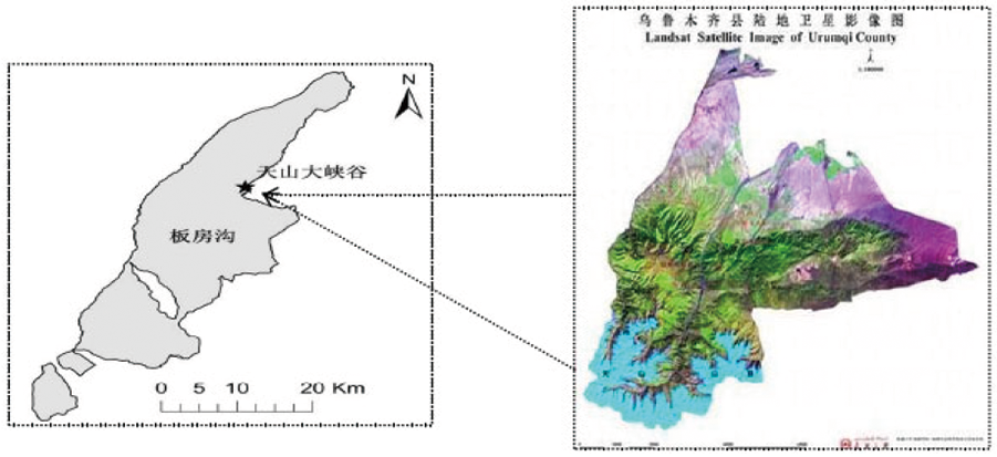
Fig.1 Topography of study area
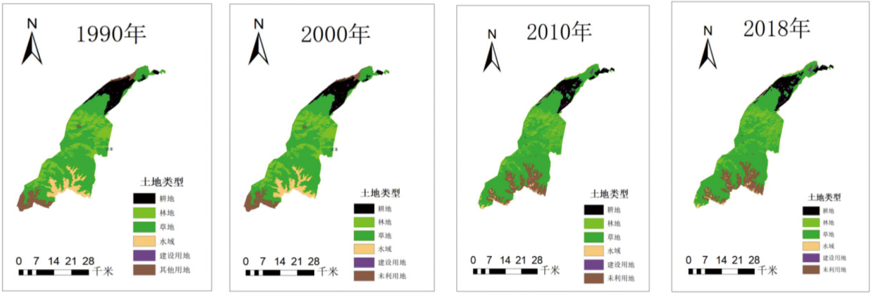
Fig.2 Land use landscape pattern in the study area
| 序号 Number | 指数名称 IndexName | 公式 Formula | 含义 Meaning |
|---|---|---|---|
| 1 | 破碎度指数指数(Ci) | Ci=ni/Ai. | 景观破碎度是指景观类型的破碎化程度。 |
| 2 | 景观分离度指数(Si) | Si= | 景观分离度描述景观类型中斑块分布的离散程度。 |
| 3 | 景观干扰度指数(Ei) | Ei=aCi+bSi+cFi. | 景观干扰指数Ei表明了不同景观对生态系统的干扰程度。 |
| 4 | 景观分维度(Fi) | Fi= | 景观分离度描述景观类型中斑块分布的离散程度。 |
| 5 | 景观损失度(Ri) | Ri=Ei×Fi. | 景观损失指数表示不同景观类型受影响后自然属性损失的程度。 |
| 6 | 景观敏感度(LSI) | $L S I=\sum_{i=1}^{n} U_{i} \times V_{i}$. | 景观敏感度指数表示不同景观受自然因素的敏感程度。 |
| 7 | 景观适应度(LAI) | LAI=PRD×SHDI×SHEI. | 景观适应度表示不同景观对生态系统的适应程度。 |
| 8 | 景观脆弱度指数(LVI) | LVI=LSI×(1-LAI). | 景观脆弱度表示生态系统内部结构的易损性。 |
Table 1 Landscape pattern index calculation
| 序号 Number | 指数名称 IndexName | 公式 Formula | 含义 Meaning |
|---|---|---|---|
| 1 | 破碎度指数指数(Ci) | Ci=ni/Ai. | 景观破碎度是指景观类型的破碎化程度。 |
| 2 | 景观分离度指数(Si) | Si= | 景观分离度描述景观类型中斑块分布的离散程度。 |
| 3 | 景观干扰度指数(Ei) | Ei=aCi+bSi+cFi. | 景观干扰指数Ei表明了不同景观对生态系统的干扰程度。 |
| 4 | 景观分维度(Fi) | Fi= | 景观分离度描述景观类型中斑块分布的离散程度。 |
| 5 | 景观损失度(Ri) | Ri=Ei×Fi. | 景观损失指数表示不同景观类型受影响后自然属性损失的程度。 |
| 6 | 景观敏感度(LSI) | $L S I=\sum_{i=1}^{n} U_{i} \times V_{i}$. | 景观敏感度指数表示不同景观受自然因素的敏感程度。 |
| 7 | 景观适应度(LAI) | LAI=PRD×SHDI×SHEI. | 景观适应度表示不同景观对生态系统的适应程度。 |
| 8 | 景观脆弱度指数(LVI) | LVI=LSI×(1-LAI). | 景观脆弱度表示生态系统内部结构的易损性。 |
| 土地类型 Land type | 1990 | 2000 | 2010 | 2018 | ||||
|---|---|---|---|---|---|---|---|---|
| 面积 Area (hm2) | 比例 Proportion (%) | 面积 Area (hm2) | 比例 Proportion (%) | 面积 Area (hm2) | 比例 Proportion (%) | 面积 Area (hm2) | 比例 Proportion (%) | |
| 耕地Arable land | 10 693.71 | 10.7 | 10 606.14 | 10.61 | 9 203.76 | 9.21 | 9 137.7 | 9.14 |
| 林地Woodland | 16 031.97 | 16.04 | 16 033.41 | 16.04 | 10 133.46 | 10.14 | 10 133.46 | 10.14 |
| 草地Grassland | 58 258.71 | 54.89 | 58 273.83 | 58.3 | 66 323.07 | 66.36 | 66 153.42 | 66.22 |
| 水域Watery | 7 554.15 | 7.56 | 7 553.7 | 7.56 | 2 020.68 | 0.72 | 2 020.68 | 2.02 |
| 建设用地Construction land | 197.73 | 0.2 | 272.88 | 0.27 | 830.61 | 0.83 | 1 066.32 | 1.07 |
| 未利用地Unused land | 7 208.82 | 7.21 | 7 213.23 | 7.21 | 11 433.51 | 11.44 | 11 433.51 | 11.44 |
Table 2 Changes in the area of landscape types from 1990 to 2018
| 土地类型 Land type | 1990 | 2000 | 2010 | 2018 | ||||
|---|---|---|---|---|---|---|---|---|
| 面积 Area (hm2) | 比例 Proportion (%) | 面积 Area (hm2) | 比例 Proportion (%) | 面积 Area (hm2) | 比例 Proportion (%) | 面积 Area (hm2) | 比例 Proportion (%) | |
| 耕地Arable land | 10 693.71 | 10.7 | 10 606.14 | 10.61 | 9 203.76 | 9.21 | 9 137.7 | 9.14 |
| 林地Woodland | 16 031.97 | 16.04 | 16 033.41 | 16.04 | 10 133.46 | 10.14 | 10 133.46 | 10.14 |
| 草地Grassland | 58 258.71 | 54.89 | 58 273.83 | 58.3 | 66 323.07 | 66.36 | 66 153.42 | 66.22 |
| 水域Watery | 7 554.15 | 7.56 | 7 553.7 | 7.56 | 2 020.68 | 0.72 | 2 020.68 | 2.02 |
| 建设用地Construction land | 197.73 | 0.2 | 272.88 | 0.27 | 830.61 | 0.83 | 1 066.32 | 1.07 |
| 未利用地Unused land | 7 208.82 | 7.21 | 7 213.23 | 7.21 | 11 433.51 | 11.44 | 11 433.51 | 11.44 |
| 时间 Time | 土地利用类型 Land use type | 耕地 Arable land | 林地 Woodland | 草地 Grass | 水域 Waters | 建设用地 Construction land | 未利用地 Unused land |
|---|---|---|---|---|---|---|---|
| 1990~2000 | 耕地 | 10 550.25 | 0.00 | 81.50 | 0.00 | 61.70 | 0.20 |
| 林地 | 0.00 | 16 031.40 | 3.90 | 0.00 | 0.00 | 0.00 | |
| 草地 | 48.80 | 5.30 | 58 180.60 | 2.10 | 20.30 | 0.70 | |
| 水域 | 0.00 | 0.00 | 2.50 | 7 551.60 | 0.00 | 0.00 | |
| 建设用地 | 0.00 | 0.00 | 0.00 | 0.00 | 190.80 | 0.00 | |
| 未利用地 | 0.4 | 0.00 | 2.10 | 0.00 | 0.00 | 7 207.20 | |
| 2000~2010 | 耕地 | 8 070.80 | 0.00 | 2 037.69 | 162.60 | 335.10 | 0.00 |
| 林地 | 11.30 | 8 194.86 | 7 799.76 | 5.60 | 0.00 | 21.90 | |
| 草地 | 988.00 | 1 911.87 | 51 197.20 | 181.89 | 357.84 | 3 658.30 | |
| 水域 | 0.00 | 0.00 | 1 241.50 | 469.30 | 0.00 | 5 843.00 | |
| 建设用地 | 129.80 | 0.00 | 5.70 | 0.00 | 137.40 | 0.00 | |
| 未利用地 | 3.90 | 26.70 | 4 066.00 | 399.60 | 0.00 | 445.30 | |
| 2010~2018 | 耕地 | 8 953.74 | 0.00 | 242.70 | 0.00 | 7.30 | 0.00 |
| 林地 | 0.00 | 10 133.46 | 0.00 | 0.00 | 0.00 | 0.00 | |
| 草地 | 184.00 | 0.00 | 65 910.70 | 0.00 | 228.40 | 0.00 | |
| 水域 | 0.00 | 0.00 | 0.00 | 2 020.70 | 0.00 | 0.00 | |
| 建设用地 | 0.00 | 0.00 | 0.00 | 0.00 | 533.20 | 0.00 | |
| 未利用地 | 0.00 | 0.00 | 0.00 | 0.00 | 11 433.50 | 0.00 |
Table 3 1990-2018 Landscape Type Transfer Matrix
| 时间 Time | 土地利用类型 Land use type | 耕地 Arable land | 林地 Woodland | 草地 Grass | 水域 Waters | 建设用地 Construction land | 未利用地 Unused land |
|---|---|---|---|---|---|---|---|
| 1990~2000 | 耕地 | 10 550.25 | 0.00 | 81.50 | 0.00 | 61.70 | 0.20 |
| 林地 | 0.00 | 16 031.40 | 3.90 | 0.00 | 0.00 | 0.00 | |
| 草地 | 48.80 | 5.30 | 58 180.60 | 2.10 | 20.30 | 0.70 | |
| 水域 | 0.00 | 0.00 | 2.50 | 7 551.60 | 0.00 | 0.00 | |
| 建设用地 | 0.00 | 0.00 | 0.00 | 0.00 | 190.80 | 0.00 | |
| 未利用地 | 0.4 | 0.00 | 2.10 | 0.00 | 0.00 | 7 207.20 | |
| 2000~2010 | 耕地 | 8 070.80 | 0.00 | 2 037.69 | 162.60 | 335.10 | 0.00 |
| 林地 | 11.30 | 8 194.86 | 7 799.76 | 5.60 | 0.00 | 21.90 | |
| 草地 | 988.00 | 1 911.87 | 51 197.20 | 181.89 | 357.84 | 3 658.30 | |
| 水域 | 0.00 | 0.00 | 1 241.50 | 469.30 | 0.00 | 5 843.00 | |
| 建设用地 | 129.80 | 0.00 | 5.70 | 0.00 | 137.40 | 0.00 | |
| 未利用地 | 3.90 | 26.70 | 4 066.00 | 399.60 | 0.00 | 445.30 | |
| 2010~2018 | 耕地 | 8 953.74 | 0.00 | 242.70 | 0.00 | 7.30 | 0.00 |
| 林地 | 0.00 | 10 133.46 | 0.00 | 0.00 | 0.00 | 0.00 | |
| 草地 | 184.00 | 0.00 | 65 910.70 | 0.00 | 228.40 | 0.00 | |
| 水域 | 0.00 | 0.00 | 0.00 | 2 020.70 | 0.00 | 0.00 | |
| 建设用地 | 0.00 | 0.00 | 0.00 | 0.00 | 533.20 | 0.00 | |
| 未利用地 | 0.00 | 0.00 | 0.00 | 0.00 | 11 433.50 | 0.00 |
| 时间 Time | 土地类型 Land type | 斑块数量 NP | 面积 Area (hm2) | 破碎度 Ci | 分离度指数 Si | 分维度指数 Fi | 干扰度指数 Ei | 脆弱度指数 Ri |
|---|---|---|---|---|---|---|---|---|
| 1990 | 耕地 | 3 | 10 693.7 | 0.000 3 | 0.025 6 | 1.512 5 | 0.310 3 | 0.18 |
| 林地 | 92 | 16 032 | 0.152 7 | 23.339 8 | 2.547 5 | 7.587 8 | 1.972 8 | |
| 草地 | 40 | 58 258.7 | 0.006 4 | 0.283 | 5.733 2 | 1.234 7 | 0.518 6 | |
| 水域 | 1 | 7 554.1 | 0.000 1 | 0.020 9 | 1.749 | 0.356 1 | 0.263 5 | |
| 建设用地 | 14 | 197.7 | 0.070 8 | 2.991 6 | 5.282 2 | 1.989 3 | 0.198 9 | |
| 未利用地 | 11 | 7 208.9 | 0.007 | 0.502 6 | 6.019 1 | 1.358 1 | 1.222 3 | |
| 2000 | 耕地 | 3 | 10 597.4 | 0.000 3 | 0.025 8 | 1.515 5 | 0.311 | 0.180 4 |
| 林地 | 92 | 16 020.05 | 0.153 8 | 23.502 3 | 2.546 3 | 7.636 8 | 1.985 6 | |
| 草地 | 43 | 58 222.3 | 0.006 7 | 0.289 6 | 5.734 3 | 1.237 1 | 0.519 6 | |
| 水域 | 1 | 7 546.86 | 0.000 1 | 0.020 9 | 1.749 3 | 0.356 2 | 0.263 6 | |
| 建设用地 | 16 | 272.61 | 0.058 7 | 2.318 4 | 3.589 9 | 1.442 8 | 0.144 3 | |
| 未利用地 | 12 | 7 202.97 | 0.007 8 | 0.541 4 | 6.020 1 | 1.370 4 | 1.233 3 | |
| 2010 | 耕地 | 14 | 9 203.76 | 0.001 5 | 0.064 3 | 1.728 3 | 0.365 7 | 0.212 1 |
| 林地 | 363 | 10 133.46 | 0.605 7 | 43.008 | 5.494 4 | 14.304 2 | 3.719 1 | |
| 草地 | 38 | 66 323.05 | 0.002 7 | 0.146 9 | 4.998 2 | 1.045 | 0.438 9 | |
| 水域 | 55 | 1 313.37 | 0.041 9 | 0.892 6 | 2.693 | 0.827 3 | 0.612 2 | |
| 建设用地 | 42 | 1 240.47 | 0.068 2 | 2.364 1 | 6.340 5 | 2.011 4 | 0.201 1 | |
| 未利用地 | 24 | 11 730.93 | 0.264 4 | 15.871 1 | 4.357 3 | 5.765 | 5.188 5 | |
| 2018 | 耕地 | 15 | 9 137.7 | 0.001 6 | 0.067 | 1.740 6 | 0.369 | 0.214 |
| 林地 | 363 | 10 133.46 | 0.605 7 | 43.007 9 | 5.494 3 | 14.304 1 | 3.719 1 | |
| 草地 | 41 | 66 153.4 | 0.003 2 | 0.157 9 | 5.056 3 | 1.060 2 | 4.164 4 | |
| 水域 | 55 | 1 313.37 | 0.041 9 | 0.892 6 | 2.693 | 0.827 3 | 0.612 2 | |
| 建设用地 | 42 | 1 314.09 | 0.063 8 | 2.207 3 | 6.188 9 | 1.931 9 | 0.193 2 | |
| 未利用地 | 29 | 11 893.02 | 0.257 5 | 15.351 2 | 4.274 5 | 5.589 | 5.030 1 |
Table 4 Patch feature index of each landscape element in the study area (1990-2018)
| 时间 Time | 土地类型 Land type | 斑块数量 NP | 面积 Area (hm2) | 破碎度 Ci | 分离度指数 Si | 分维度指数 Fi | 干扰度指数 Ei | 脆弱度指数 Ri |
|---|---|---|---|---|---|---|---|---|
| 1990 | 耕地 | 3 | 10 693.7 | 0.000 3 | 0.025 6 | 1.512 5 | 0.310 3 | 0.18 |
| 林地 | 92 | 16 032 | 0.152 7 | 23.339 8 | 2.547 5 | 7.587 8 | 1.972 8 | |
| 草地 | 40 | 58 258.7 | 0.006 4 | 0.283 | 5.733 2 | 1.234 7 | 0.518 6 | |
| 水域 | 1 | 7 554.1 | 0.000 1 | 0.020 9 | 1.749 | 0.356 1 | 0.263 5 | |
| 建设用地 | 14 | 197.7 | 0.070 8 | 2.991 6 | 5.282 2 | 1.989 3 | 0.198 9 | |
| 未利用地 | 11 | 7 208.9 | 0.007 | 0.502 6 | 6.019 1 | 1.358 1 | 1.222 3 | |
| 2000 | 耕地 | 3 | 10 597.4 | 0.000 3 | 0.025 8 | 1.515 5 | 0.311 | 0.180 4 |
| 林地 | 92 | 16 020.05 | 0.153 8 | 23.502 3 | 2.546 3 | 7.636 8 | 1.985 6 | |
| 草地 | 43 | 58 222.3 | 0.006 7 | 0.289 6 | 5.734 3 | 1.237 1 | 0.519 6 | |
| 水域 | 1 | 7 546.86 | 0.000 1 | 0.020 9 | 1.749 3 | 0.356 2 | 0.263 6 | |
| 建设用地 | 16 | 272.61 | 0.058 7 | 2.318 4 | 3.589 9 | 1.442 8 | 0.144 3 | |
| 未利用地 | 12 | 7 202.97 | 0.007 8 | 0.541 4 | 6.020 1 | 1.370 4 | 1.233 3 | |
| 2010 | 耕地 | 14 | 9 203.76 | 0.001 5 | 0.064 3 | 1.728 3 | 0.365 7 | 0.212 1 |
| 林地 | 363 | 10 133.46 | 0.605 7 | 43.008 | 5.494 4 | 14.304 2 | 3.719 1 | |
| 草地 | 38 | 66 323.05 | 0.002 7 | 0.146 9 | 4.998 2 | 1.045 | 0.438 9 | |
| 水域 | 55 | 1 313.37 | 0.041 9 | 0.892 6 | 2.693 | 0.827 3 | 0.612 2 | |
| 建设用地 | 42 | 1 240.47 | 0.068 2 | 2.364 1 | 6.340 5 | 2.011 4 | 0.201 1 | |
| 未利用地 | 24 | 11 730.93 | 0.264 4 | 15.871 1 | 4.357 3 | 5.765 | 5.188 5 | |
| 2018 | 耕地 | 15 | 9 137.7 | 0.001 6 | 0.067 | 1.740 6 | 0.369 | 0.214 |
| 林地 | 363 | 10 133.46 | 0.605 7 | 43.007 9 | 5.494 3 | 14.304 1 | 3.719 1 | |
| 草地 | 41 | 66 153.4 | 0.003 2 | 0.157 9 | 5.056 3 | 1.060 2 | 4.164 4 | |
| 水域 | 55 | 1 313.37 | 0.041 9 | 0.892 6 | 2.693 | 0.827 3 | 0.612 2 | |
| 建设用地 | 42 | 1 314.09 | 0.063 8 | 2.207 3 | 6.188 9 | 1.931 9 | 0.193 2 | |
| 未利用地 | 29 | 11 893.02 | 0.257 5 | 15.351 2 | 4.274 5 | 5.589 | 5.030 1 |
| 时间 Time | 斑块数量 Number of plaques | 斑块密度 Patch density | 最大斑块指数 Maximum plaque index | 蔓延度指数 Sprawl Index | 香农多样性指数 Shannon Diversity Index | 香农均匀度指数 Shannon Uniformity Index | 聚集度指数 Aggregation index |
|---|---|---|---|---|---|---|---|
| 1990 | 161 | 0.034 9 | 10.670 0 | 63.869 4 | 1.610 4 | 0.671 6 | 97.831 1 |
| 2000 | 167 | 0.026 5 | 7.808 7 | 63.668 5 | 1.613 3 | 0.672 8 | 97.673 3 |
| 2010 | 536 | 0.116 3 | 11.726 1 | 66.748 9 | 1.546 8 | 0.603 0 | 96.825 3 |
| 2018 | 545 | 0.118 2 | 11.726 1 | 66.565 5 | 1.553 6 | 0.605 7 | 96.780 3 |
Table 5 Research Area Landscape Level Index (1990-2018)
| 时间 Time | 斑块数量 Number of plaques | 斑块密度 Patch density | 最大斑块指数 Maximum plaque index | 蔓延度指数 Sprawl Index | 香农多样性指数 Shannon Diversity Index | 香农均匀度指数 Shannon Uniformity Index | 聚集度指数 Aggregation index |
|---|---|---|---|---|---|---|---|
| 1990 | 161 | 0.034 9 | 10.670 0 | 63.869 4 | 1.610 4 | 0.671 6 | 97.831 1 |
| 2000 | 167 | 0.026 5 | 7.808 7 | 63.668 5 | 1.613 3 | 0.672 8 | 97.673 3 |
| 2010 | 536 | 0.116 3 | 11.726 1 | 66.748 9 | 1.546 8 | 0.603 0 | 96.825 3 |
| 2018 | 545 | 0.118 2 | 11.726 1 | 66.565 5 | 1.553 6 | 0.605 7 | 96.780 3 |
| 生态风险类型 Ecological risk type | 年份 Years | |||||||
|---|---|---|---|---|---|---|---|---|
| 1990年 | 百分比 Percentage | 2000年 | 百分比 Percentage | 2010年 | 百分比 Percentage | 2018年 | 百分比 Percentage | |
| 低生态风险 Low ecological risk | 452.565 | 0.453 | 446.297 | 0.447 | 492.773 | 0.493 | 512.156 | 0.512 |
| 较低生态风险 Lower ecological risk | 168.360 | 0.168 | 236.687 | 0.237 | 216.416 | 0.217 | 204.087 | 0.204 |
| 中生态风险 Ecological risk | 140.153 | 0.140 | 154.431 | 0.155 | 149.545 | 0.150 | 133.584 | 0.134 |
| 较高生态风险 Higher ecological risk | 138.598 | 0.139 | 114.560 | 0.115 | 98.255 | 0.098 | 106.456 | 0.107 |
| 高生态风险区 High ecological risk | 99.830 | 0.100 | 47.530 | 0.048 | 42.518 | 0.043 | 43.223 | 0.043 |
Table 6 Areas of ecological risk areas from 1990 to 2018
| 生态风险类型 Ecological risk type | 年份 Years | |||||||
|---|---|---|---|---|---|---|---|---|
| 1990年 | 百分比 Percentage | 2000年 | 百分比 Percentage | 2010年 | 百分比 Percentage | 2018年 | 百分比 Percentage | |
| 低生态风险 Low ecological risk | 452.565 | 0.453 | 446.297 | 0.447 | 492.773 | 0.493 | 512.156 | 0.512 |
| 较低生态风险 Lower ecological risk | 168.360 | 0.168 | 236.687 | 0.237 | 216.416 | 0.217 | 204.087 | 0.204 |
| 中生态风险 Ecological risk | 140.153 | 0.140 | 154.431 | 0.155 | 149.545 | 0.150 | 133.584 | 0.134 |
| 较高生态风险 Higher ecological risk | 138.598 | 0.139 | 114.560 | 0.115 | 98.255 | 0.098 | 106.456 | 0.107 |
| 高生态风险区 High ecological risk | 99.830 | 0.100 | 47.530 | 0.048 | 42.518 | 0.043 | 43.223 | 0.043 |
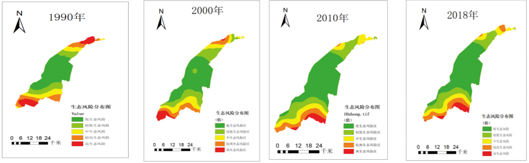
Fig.3 Landscape ecological risk spatial pattern
| [1] | 谢花林. 基于景观结构的土地利用生态风险空间特征分析—以江西兴国县为例[J]. 中国环境科学, 2011, 31(4): 688-695. |
| XIE Hualin. Spatial characteristic analysis of land use eco-risk based on landscape structure:a case study in Xingguo County, Jiangxi Province[J]. China Environmental Science, 2011, 31(4): 688-695. | |
| [2] |
Strohbach M W, Haase D. Above-ground carbon storage by urban trees in Leipzig, Germany: Analysis of patterns in a European city[J]. Landscape and Urban Planning, 2012, 104(1): 95-104.
DOI URL |
| [3] |
Cook E A. Landscape structure indices for assessing urban ecological networks[J]. Landscape and Urban Planning, 2002, 58(2): 269-280.
DOI URL |
| [4] |
Ramalho C E, Laliberté E, Poot P, et al. Complex effects of fragmentation on remnant woodland plant communities of a rapidly urbanizing biodiversity hotspot[J]. Ecology, 2014, 95(9): 2466-2478.
DOI URL |
| [5] | 邬建国, 景观生态学-格局、过程、尺度与等级 (第二版)[M]. 北京: 高等教育出版社, 2007: 112-113. |
| WU Jianguo. Landscape Ecology-Pattern, Process, Scale and Level (Second Ed.)[M]. Beijing: Higher Education Press, 2007: 112-113. | |
| [6] | 曾辉, 刘国军. 基于景观结构的区域生态风险分析[J]. 中国环境科学, 1999, 20(1): 43-45. |
| ZENG Hui, LIU Guojun. Regional ecological risk analysis based on landscape structure[J]. China Environmental Science, 1999, 20(1): 43-45. | |
| [7] | 陈百明, 周小萍, 土地利用现状分类国家标准的解读[J]. 自然资源学报, 2007, 22(6): 994-1003. |
| CHEN Baiming, ZHOU Xiaoping. Explanation of Current Land Use Condition Classification for National Standard of the People's Republic of China[J]. Journal of Natural Resources, 2007, 22(6): 994-1003. | |
| [8] | 郭怀成, 都小尚, 刘永, 等. 基于景观格局分析的区域规划环评方法[J]. 地理研究, 2011, 30(9): 1713-1724. |
| GUO Huaicheng, DU Xiaoshang, LIU Yong, et al. A landscape pattern analysis-based methodology framework for regional planning environmental assessment[J]. Geographical Research, 2011, 30(9): 1713-1724. | |
| [9] |
李小妹, 严平. 中国北方地区沙漠与河流景观格局[J]. 地理科学进展, 2014, 33(9): 1198-1208.
DOI |
|
LI Xiaomei, YAN Ping. Landscape pattern characteristics of deserts and rivers in Northern China[J]. Progress in Geography, 2014, 33(9): 1198-1208.
DOI |
|
| [10] | 阿布都热合曼·哈力克, 卞正富, 瓦哈普·哈力克. 吐鲁番盆地水资源运转规律及其持续利用研究[J]. 水文, 2009, 29(3): 50-54. |
| Abudureheman Khaliq, BIAN Zhengfu, Wahapu Khaliq. Discussion on the Water Resources and Their Rational Development and Utilization in Turpan Basin[J]. Journal of China Hydrology, 2009, 29(3): 50-54. | |
| [11] | 王娟, 崔保山, 刘杰, 等. 云南澜沧江流域土地利用及其变化对景观生态风险的影响[J]. 环境科学学报, 2008, 28(2): 269-277. |
| WANG Juan, CUI Baoshan, LIU Jie, et al. The effect of land use and its change on ecological risk in the Lancang River watershed of Yunnan Province at the landscape scale[J]. Journal of Environmental Science, 2008, 28(2): 269-277. | |
| [12] | 张雅杰, 方媛, 贺法法, 等. 基于土地利用变化模拟的生态风险动态评价[J]. 测绘空间地理信息, 2016, 39(1): 5-8,12. |
| ZHANG Yajie, FANG Yuan, HE Fafa, et al. Ecological Risk Dynamic Assessment Based on Simulation of Land Use Change[J]. Surveying and Mapping Spatial Geographic Information, 2016, 39(1): 5-8,12. | |
| [13] | 陈鹏, 潘晓玲. 干旱区内陆流域区域景观生态风险分析:以阜康三工河流域为例[J]. 生态学杂志, 2003, 22(4): 116-120. |
| CHEN Peng, PAN Xiaoling. Ecological risk analysis of regional landscape in inland river watershed of arid area—a case study of Sangong River Basin in Fukang[J]. Chinese Journal of Ecology, 2003, 22(4): 116-120. | |
| [14] | 张月, 张飞, 王娟, 等. 基于LUCC的艾比湖区域生态风险评价及预测研究[J]. 中国环境科学, 2016, 36(11): 3465-3474. |
| ZHANG Yue, ZHANG Fei, WANG Juan, et al. Ecological risk assessment and prediction of Ebinur Lake region based on Land use/Land cover change[J]. China Environmental Science, 2016, 36(11): 3465-3474. | |
| [15] | 苏海民, 何爱霞. 基于RS和地统计学的福州市土地利用分析[J]. 自然资源学报, 2010, 25(1): 91-99. |
| SU Haimin, HE Aixia. Analysis of land use in Fuzhou based on RS and geostatistics[J]. Journal of Natural Resources, 2010, 25(1): 91-99. | |
| [16] |
谢小平, 陈芝聪, 王芳, 等. 基于景观格局的太湖流域生态风险评估[J]. 应用生态学报, 2017, 28(10): 3369-3377.
PMID |
|
XIE Xiaoping, CHEN Zhicong, WANG Fang, et al. Ecological risk assessment of Taihu Lake basin based on landscape pattern[J]. Chinese Journal of Applied Ecology, 2017, 28(10): 3369-3377.
DOI PMID |
|
| [17] | 高宾, 李小玉, 李志刚, 等. 基于景观格局的锦州湾沿海经济开发区生态风险分析[J]. 生态学报, 2011, 31(12): 3441-3450. |
| GAO Bin, LI Xiaoyu, LI Zhigang, et al. Assessment of ecological risk of coastal economic developing zone in Jinzhou Bay based on landscape pattern[J]. Acta Ecologica Sinica, 2011, 31(12): 3441-3450. | |
| [18] | 李菊荣, 王延华, 唐湘玲, 等. 新疆玛纳斯河流域土地利用变化特征及影响因素研究[J]. 土壤通报, 2018, 49(1): 61-68. |
| LI Jurong, WANG Yanhua, TANG Xiangling, et al. The Spatial-Temporal Characteristics of Land Use Change in the Manas River Basin and Influencing Factors[J]. Soil Bulletin, 2018, 49(1): 61-68. | |
| [19] | 张甜, 刘焱序, 彭建, 等. 深圳市景观生态风险多尺度关联分析[J]. 生态学杂志, 2016, 35(9): 2478-2486. |
| ZHANG Tian, LIU Yanxu, PENG Jian, et al. Correlation of the landscape ecological risk on multi-scales in Shenzhen City[J]. Chinese Journal of Ecology, 2016, 35(9): 2478-2486. | |
| [20] | 许妍, 高俊峰, 赵家虎, 等. 流域生态风险评价研究进展[J]. 生态学报, 2012, 32(1): 284-292. |
|
XU Yan, GAO Junfeng, ZHAO Jiahu, et al. The research progress and prospect of watershed ecological risk assessment[J]. Acta Ecologica Sinica, 2012, 32(1): 284-292.
DOI URL |
|
| [21] | 徐兰, 罗维, 周宝同. 基于土地利用变化的农牧交错带典型流域生态风险评价—以洋河为例[J]. 自然资源学报, 2015, 30(4): 580-590. |
| XU Lan, LUO Wei, ZHOU Baotong. Landscape Ecological Risk Assessment of Farming-Pastoral Ecozone Based on Land Use Change-A Case Study of the Yanghe Watershed, China[J]. Journal of Natural Resources, 2015, 30(4): 580-590. | |
| [22] | 李月月, 黄义雄, 杨阳, 等. 基于景观结构的福建省沿海生态风险时空特征[J]. 水土保持通报, 2018, 38(4): 241-246. |
| LI Yueyue, HUANG Yixiong, YANG Yang, et al. Temporal and Spatial Characteristics of Coastal Ecological Risk in Fujian Province Based on Landscape Structure[J]. Water and Soil Conservation Bulletin, 2018, 38(4): 241-246. | |
| [23] | 王亚娟, 王鹏, 韩文文, 等. 宁夏中部干旱带生态移民过程生态风险时空分异—以红寺堡区为例[J]. 干旱区地理, 2018, 41(4): 817-825. |
| WANG Yajuan, WANG Peng, HAN Wenwen, et al. Spatial and temporal variation of ecological risk in the process of ecological immigration in the arid zone of central Ningxia:A case of Hongsibu District[J]. Arid Zone Geography, 2018, 41(4): 817-825. | |
| [24] | 肖欢, 李成英, 冉港雄, 等. 剑门关丹霞地貌类型景观格局时空变化研究[J]. 地理空间信息,2019,17(4):75-78, 102, 10. |
| XIAO Huan, LI Chengying, RAN Gangxiong, et al. Study on Spatio-temporal Variation of Landscape Pattern of Jianmen Pass Danxia Landform[J]. Geospatial Information, 2019, 17(4):75-78, 102, 10. | |
| [25] | 王成, 魏朝富, 袁敏, 等. 不同地貌类型下景观格局对土地利用方式的响应[J]. 农业工程学报, 2007,(9): 64-71, 293. |
| WANG Cheng, WEI Chaofu, YUAN Min, et al. Response to the landscape pattern on the land use pattern under the different types of geomorphology[J]. Journal of Agricultural Engineering, 2007, 23(9): 64-71, 293. |
| Viewed | ||||||
|
Full text |
|
|||||
|
Abstract |
|
|||||