
新疆农业科学 ›› 2021, Vol. 58 ›› Issue (10): 1838-1845.DOI: 10.6048/j.issn.1001-4330.2021.10.009
• 作物遗传育种·种质资源·分子遗传学·耕作栽培·生理生化·农产品分析检测 • 上一篇 下一篇
吕金城( ), 王振锡(), 杨勇强, 曲延斌, 马琪瑶, 朱思明
收稿日期:2020-08-22
出版日期:2021-10-20
发布日期:2021-10-26
通信作者:
王振锡
作者简介:吕金城(1995-),男,新疆乌鲁木齐人,硕士研究生,研究方向为林业3s技术及应用,(E-mail) 1287460632@qq.com
基金资助:
Jincheng LÜ(), Zhenxi WANG(), Yongqiang YANG, Yanbin QU, Qiyao MA, Siming ZHU
Received:2020-08-22
Online:2021-10-20
Published:2021-10-26
Correspondence author:
Zhenxi WANG
Supported by:摘要:
【目的】提取影像高程数据建立模型反演天山云杉林分蓄积量,为天然林保护工程实施后天山云杉生态恢复与科学管理提供参考依据。【方法】以新疆天山西部巩留县恰西森林公园的天山云杉(Picea Schrenkiana var. tianshanica)为研究对象,无人机航拍影像与样地每木检尺为数据源,使用点云分类与克里金插值法提取无人机影像高程数据得到天山云杉树高,根据样地实测数据建立胸径树高模型,最终根据胸径树高模型反演天山云杉林林分蓄积量。【结果】利用无人机影像提取树高与实测树高存在显著正相关关系,提取平均精度为88.42%,建立天山云杉胸径-冠幅模型的相关系数为0.696,而胸径-树高模型的相关系数为0.730;验证胸径-树高模型,计算RMSE值为12.386,拟合效果显著。基于胸径-树高模型反演林分蓄积量精度为87.66%,与实测值比对,残差值大部分落在(-2,+2)残差区间。【结论】采用局部最大值算法对天山云杉林树高信息的提取效果较好,建立胸径-树高模型弥补了无人机不能对胸径直接测量的缺陷,进而反演天山云杉林林分蓄积量。
中图分类号:
吕金城, 王振锡, 杨勇强, 曲延斌, 马琪瑶, 朱思明. 基于无人机影像的天山云杉林树高提取及蓄积量的反演[J]. 新疆农业科学, 2021, 58(10): 1838-1845.
Jincheng LÜ, Zhenxi WANG, Yongqiang YANG, Yanbin QU, Qiyao MA, Siming ZHU. Height Extraction and Growing Stock Inversion of Picea schrenkiana var. tianshanica in Tianshan Mountain Based on UAV Image[J]. Xinjiang Agricultural Sciences, 2021, 58(10): 1838-1845.
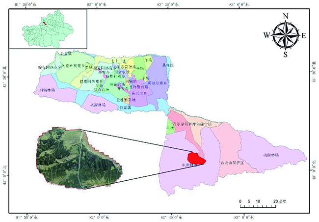
图1 研究区位置示意
Fig.1 Location of the research area map
| 参数类型 Parameter type | 参数数据 Parameter data |
|---|---|
| 传感器类型 Sensor type | CMOS |
| 传感器尺寸 Sensor size | 全画幅 |
| 有效像素 Effective Pixels | 4 240万 |
| 焦距 Focal length | 35 mm |
| 像素大小 Pixel size | 4.53×4.53 (μm) |
表1 SONY DSC-RX1RM2(35 mm)数码相机参数
Table 1 DSC-RX1RM2(35 mm)SONY digital camera parameters table
| 参数类型 Parameter type | 参数数据 Parameter data |
|---|---|
| 传感器类型 Sensor type | CMOS |
| 传感器尺寸 Sensor size | 全画幅 |
| 有效像素 Effective Pixels | 4 240万 |
| 焦距 Focal length | 35 mm |
| 像素大小 Pixel size | 4.53×4.53 (μm) |
| 变量 Variable | 最大值 Maximum value | 最小值 Minimum value | 平均值 Average value |
|---|---|---|---|
| 胸径 Diameter at breast height(cm) | 148.97 | 5.00 | 43.49 |
| 树高 Tree height(m) | 60.40 | 3.00 | 25.76 |
| 冠幅 Crown breadth (m) | 10.2 | 0.58 | 3.35 |
表2 样地每木检尺数据
Table 2 Data of per wood scale in sample plot
| 变量 Variable | 最大值 Maximum value | 最小值 Minimum value | 平均值 Average value |
|---|---|---|---|
| 胸径 Diameter at breast height(cm) | 148.97 | 5.00 | 43.49 |
| 树高 Tree height(m) | 60.40 | 3.00 | 25.76 |
| 冠幅 Crown breadth (m) | 10.2 | 0.58 | 3.35 |
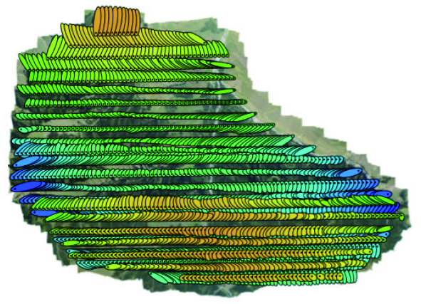
图2 密集点云数据生成
Fig.2 Generate dense point cloud data
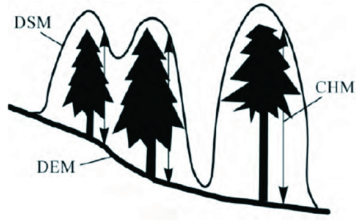
图3 冠层高度模型构建原理
Fig.3 Construction principle of canopy height model
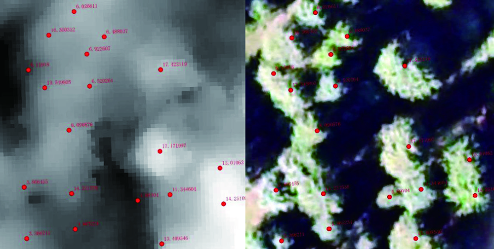
图4 树冠顶点高度提取
Fig.4 Top height extraction from canopy
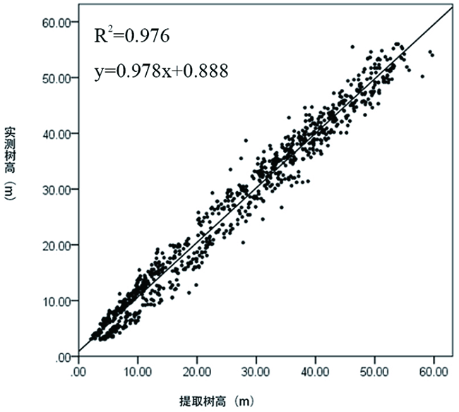
图5 树高提取值与实测值关系散点图
Fig.5 Scatter plot of relation between tree height extraction value and measured value
| 方程 Model | R2 | F | df1 | df2 | Sig. |
|---|---|---|---|---|---|
| 线性Linear function | 0.587 | 1 435.558 | 1 | 1 009 | 0.000 |
| 对数Logarithmic function | 0.606 | 1 552.731 | 1 | 1 009 | 0.000 |
| 倒数Reciprocal function | 0.504 | 1 027.327 | 1 | 1 009 | 0.000 |
| 二次Quadratic function | 0.606 | 775.227 | 2 | 1 008 | 0.000 |
| 三次Cubic function | 0.623 | 555.753 | 3 | 1 007 | 0.000 |
| 复合Function of function | 0.580 | 1 395.627 | 1 | 1 009 | 0.000 |
| 幂Power function | 0.696 | 2 308.688 | 1 | 1 009 | 0.000 |
| S曲线S-curve | 0.673 | 2 074.368 | 1 | 1 009 | 0.000 |
| 增长Increasing function | 0.580 | 1 395.627 | 1 | 1 009 | 0.000 |
| 指数Exponential function | 0.580 | 1 395.627 | 1 | 1 009 | 0.000 |
表3 胸径冠幅模型及参数统计
Table 3 Summary of parameters of DBH crown width model
| 方程 Model | R2 | F | df1 | df2 | Sig. |
|---|---|---|---|---|---|
| 线性Linear function | 0.587 | 1 435.558 | 1 | 1 009 | 0.000 |
| 对数Logarithmic function | 0.606 | 1 552.731 | 1 | 1 009 | 0.000 |
| 倒数Reciprocal function | 0.504 | 1 027.327 | 1 | 1 009 | 0.000 |
| 二次Quadratic function | 0.606 | 775.227 | 2 | 1 008 | 0.000 |
| 三次Cubic function | 0.623 | 555.753 | 3 | 1 007 | 0.000 |
| 复合Function of function | 0.580 | 1 395.627 | 1 | 1 009 | 0.000 |
| 幂Power function | 0.696 | 2 308.688 | 1 | 1 009 | 0.000 |
| S曲线S-curve | 0.673 | 2 074.368 | 1 | 1 009 | 0.000 |
| 增长Increasing function | 0.580 | 1 395.627 | 1 | 1 009 | 0.000 |
| 指数Exponential function | 0.580 | 1 395.627 | 1 | 1 009 | 0.000 |
| 方程 Model | R2 | F | df1 | df2 | Sig. |
|---|---|---|---|---|---|
| 线性Linear function | 0.634 | 1 745.357 | 1 | 1 009 | 0.000 |
| 对数Logarithmic function | 0.597 | 1 494.405 | 1 | 1 009 | 0.000 |
| 倒数Reciprocal function | 0.424 | 743.741 | 1 | 1 009 | 0.000 |
| 二次Quadratic function | 0.639 | 894.034 | 2 | 1 008 | 0.000 |
| 三次Cubic function | 0.645 | 609.924 | 3 | 1 007 | 0.000 |
| 复合Function of function | 0.689 | 2 233.585 | 1 | 1 009 | 0.000 |
| 幂Power function | 0.730 | 2 724.231 | 1 | 1 009 | 0.000 |
| S曲线S-curve | 0.601 | 1 520.076 | 1 | 1 009 | 0.000 |
| 增长Increasing function | 0.689 | 2 233.585 | 1 | 1 009 | 0.000 |
| 指数Exponential function | 0.689 | 2 233.585 | 1 | 1 009 | 0.000 |
表4 树高胸径模型及参数统计
Table 4 Summary of parameters of DBH tree height model
| 方程 Model | R2 | F | df1 | df2 | Sig. |
|---|---|---|---|---|---|
| 线性Linear function | 0.634 | 1 745.357 | 1 | 1 009 | 0.000 |
| 对数Logarithmic function | 0.597 | 1 494.405 | 1 | 1 009 | 0.000 |
| 倒数Reciprocal function | 0.424 | 743.741 | 1 | 1 009 | 0.000 |
| 二次Quadratic function | 0.639 | 894.034 | 2 | 1 008 | 0.000 |
| 三次Cubic function | 0.645 | 609.924 | 3 | 1 007 | 0.000 |
| 复合Function of function | 0.689 | 2 233.585 | 1 | 1 009 | 0.000 |
| 幂Power function | 0.730 | 2 724.231 | 1 | 1 009 | 0.000 |
| S曲线S-curve | 0.601 | 1 520.076 | 1 | 1 009 | 0.000 |
| 增长Increasing function | 0.689 | 2 233.585 | 1 | 1 009 | 0.000 |
| 指数Exponential function | 0.689 | 2 233.585 | 1 | 1 009 | 0.000 |
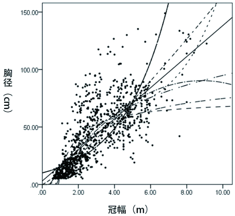
图6 胸径冠幅模型曲线
Fig.6 Curve of DBH crown width model
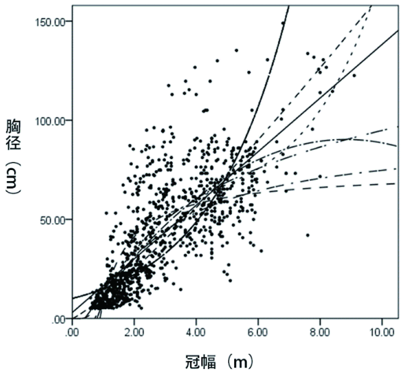
图7 胸径树高模型曲线
Fig.7 Curve of DBH tree height model
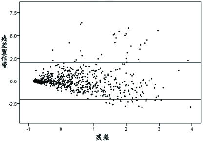
图8 云杉蓄积量残差分布
Fig.8 Residual distribution of spruce growing stock
| [1] |
吴霜, 延晓冬, 张丽娟. 中国森林生态系统能值与服务功能价值的关系[J]. 地理学报, 2014, 69(3):334-342.
DOI |
| WU Shuang, YAN Xiaodong, ZHANG Lijuan. The relationship between forest ecosystem emergy and forest ecosystem service value in China[J]. Acta Geographica Sincia, 2014, 69(3):334-342. | |
| [2] | 于生华. 天然林资源共享保护工程在我区经济社会发展中的地位和重要性[J]. 新疆林业, 2015,(1):21-23. |
| YU Shenghua. The status and importance of natural forest resource sharing and protection project ineconomic and social development[J]. Forestry of Xinjiang, 2015,(1):21-23. | |
| [3] | 李明辉, 何风华, 刘云, 等. 天山云杉种群空间格局与动态[J]. 生态学报, 2005, 25(5):1000-1006. |
| LI Minghui, HE Fenghua, LIU Yun, et al. Spatial distribution pattern of tree individuals in the PiceaSchrenkianavartianshanica[J]. Acta Ecologica Sinica, 2005, 25(5):1000-1006. | |
| [4] | 王雅佩, 王振锡, 刘梦婷, 等. 基于无人机影像天山云杉林主伐迹地提取研究[J]. 新疆农业科学, 2019, 56(7):1315-1327. |
| WANG Yapei, WANG Zhengxi, LIU Mengting, et al. Research on estimation of stand density of regenerate PiceaSchrenkianavartianshanica based on UAV Image[J]. Xinjiang Agricultural Sciences, 2019, 56(7):1315-1327. | |
| [5] |
Song C, Dickinson M B, Su L, et al. Estimating average tree crown size using spatial information from Ikonos and QuickBird images: Across-sensor and across-site comparisons[J]. Remote Sensing of Environment, 2010, 114(5):1099-1107.
DOI URL |
| [6] | 史洁青, 冯仲科, 刘金成. 基于无人机遥感影像的高精度森林资源调查系统设计与试验[J]. 农业工程学报, 2017, 33(11):82-90. |
| SHI Jieqing, FENG Zhongke, LIU Jincheng. Design and experiment of high precision forest resource investigation system based on UAV remote sensing images[J]. Transactions of the Chinese Society of Agricultural Engineering, 2017, 33(11):82-90. | |
| [7] | 贾嘉辉. 高分遥感森林蓄积量估测算法研究[D]. 西安: 西安科技大学, 2017. |
| JIA Jiahui. Study on forest Stock Estimation Algorithm for high resolution remote sensing[D]. Xi’an: Xian Technology University, 2017. | |
| [8] | 曹霖. 基于Sentinel-2影像的延庆区森林蓄积量遥感估测研究[D]. 北京: 北京林业大学, 2019. |
| CAO Lin. Estimation of Pinuskesiya var. langbianensis Forest Stock Volume based on Sentinel-1A SAR Image Remote sensing Estimation of Forest stock in Yanqing District based on Sentinel-2 image[D]. Beijing: Beijing Forestry University, 2019. | |
| [9] | 李赟. 基于UAV高分影像的林木冠幅提取与蓄积量估测研究[D]. 南京: 南京林业大学, 2017. |
| LI Yun. Extraction and Volume Estimation of Tree Crown Based on High UAV Image[D]. Nanjing: Nanjing Forestry University, 2017. | |
| [10] | 李蕴雅. UAV/RS3D像对森林信息提取方法研究[D]. 北京:北京林业大学, 2016. |
| LI Yunya. UAV/RS3D Image Research on Forest Information Extraction Method[D]. Beijing: Beijing Forestry University, 2016. | |
| [11] | 周小成, 何艺, 黄洪宇, 等. 基于两期无人机影像的针叶林伐区蓄积量估算[J]. 林业科学, 2019, 55(11):117-125. |
| ZHOU Xiaocheng, HE Yi, HUANG Hongyu, et al. Estimation of coniferous forest cutting volume based on two-phase UAV image[J]. Scientia Silvae Sinicae. 2019, 55(11):117-125. | |
| [12] | 卢妮妮, 王新杰, 张鹏, 等. 不同林龄杉木胸径树高与冠幅的通径分析[J]. 东北林业大学学报, 2015, 43(4):12-16. |
| LU Nini, WANG Xinjie, ZHANG Peng, et al. Path analysis between diameter at breast height, height and crown width of cunnin ghamia lanceolata in different age[J]. Journal of Northeast Forestry University, 2015, 43(4):12-16. | |
| [13] | 李亚东, 曹明兰, 李长青, 等. 无人机森林航摄影像三维点云估测林分蓄积量研究[J]. 中南林业科技大学学报, 2019, 39(3):56-60. |
| LI Yadong, CAO Minglan, LI Changqin, et al. A research on three-dimensional point cloud estimation of forest stand volume by UAV forest aerial survey images[J]. Journal of Central South University of Forestry & Technology, 2019, 39(3):56-60. | |
| [14] | 王伟. 无人机影像森林信息提取与模型研建[D]. 北京: 北京林业大学, 2015. |
| WANG Wei. Information extraction and model construction of UAV image forest[D]. Beijing: Beijing Forestry University, 2015. | |
| [15] | Wang L, Gong P, Biging G S. Individual Tree-Crown Delineation and Treetop Detection in High-Spatial-Resolution Aerial Imagery[J]. Photogrammetric Engineering & Remote Sensing, 2004, 70(3):351-358. |
| [16] | Lun Wu, Yunhai Zhang, Yong Gao, et al. Individual Tree-Crown Delineation and Treetop Detection in High-Spatial-Resolution Aerial Imagery[J]. Remote Sensing of Environment, 2004, 114(5):20-24. |
| [17] |
Culvenor D S, Mikko Vastaranta, Markus Holopainen, et al. TIDA: an algorithm for the delineation of tree crowns in high spatial resolution remotely sensed imagery[J]. Computers & Geosciences, 2002, 28(1):33-44.
DOI URL |
| [18] | 李海奎, 法蕾. 基于分级的全国主要树种树高-胸径曲线模型[J]. 林业科学, 2011, 47(10):83-90. |
| LI Haikui, Fa Lei. Height-Diameter Model for Major Tree Species in China Using the Classified Height Method[J]. Scientia Silvae Sinicae, 2011, 47(10):83-90. | |
| [19] |
Iizuka, Iizuka, K., Yonehara, T., Itoh, M., Kosugi, Y. Estimating Tree Height and Diameter at Breast Height (DBH) from Digital Surface Models and Orthophotos Obtained with an Unmanned Aerial System for a Japanese Cypress (Chamaecyparisobtusa) Forest[J]. Remote Sensing, 2017, 10(1):277-8568.
DOI URL |
| [1] | 席丽, 李思瑶, 夏晓莹, 陈玉雯, 李林, 王杰, 马小龙, 米尔扎提·柯尼加里木, 阿丽耶·麦麦提, 王卫霞. 不同郁闭度天山云杉林土壤养分特征[J]. 新疆农业科学, 2023, 60(9): 2216-2222. |
| [2] | 曲延斌, 王振锡, 胡天祺, 董巍, 陈哲. 基于机载激光雷达影像的天山云杉林树高提取及蓄积量反演[J]. 新疆农业科学, 2023, 60(4): 958-964. |
| [3] | 夏晓莹, 李思瑶, 王杰, 马小龙, 席丽, 米尔扎提·柯尼加里木, 阿丽耶·麦麦提, 王卫霞. 地形因子对天山北坡天山云杉林土壤有机碳的影响[J]. 新疆农业科学, 2023, 60(4): 965-973. |
| [4] | 胡文聪, 潘存德, 赵善超, 宋梦真, 童海麦, 田晨阳. 天山北坡中部天山云杉1 a生天然更新幼苗存活数量与功能性状的微生境分析[J]. 新疆农业科学, 2023, 60(2): 454-463. |
| [5] | 吕金城, 王振锡, 杨勇强, 曲延斌, 马琪瑶. 基于WorldView-2影像和随机森林算法的天山云杉蓄积量反演[J]. 新疆农业科学, 2022, 59(8): 1992-1998. |
| [6] | 葛瑶, 王振锡. 天山云杉林不同林型物种多样性对土壤因子的响应[J]. 新疆农业科学, 2022, 59(1): 134-144. |
| [7] | 裴媛, 王振锡, 朱思名, 葛瑶, 师玉霞. 天山西部云杉林群落数量分类与排序[J]. 新疆农业科学, 2021, 58(2): 313-323. |
| [8] | 杨勇强, 王振锡, 师玉霞, 连玲, 高亚利. 基于无人机影像的天山云杉林单木树冠信息提取[J]. 新疆农业科学, 2020, 57(8): 1484-1492. |
| [9] | 王卫霞, 杨光, 王振锡. 更新方式对天山云杉林土壤碳氮的影响[J]. 新疆农业科学, 2020, 57(8): 1474-1483. |
| [10] | 王雅佩, 王振锡, 刘梦婷, 李擎, 杨勇强. 基于无人机影像天山云杉林主伐迹地提取研究[J]. 新疆农业科学, 2019, 56(7): 1312-1324. |
| [11] | 禹思慧, 王振锡, 王雅佩, 刘梦婷, 李擎. 高强度采伐对天山云杉更新群落物种组成的影响[J]. 新疆农业科学, 2018, 55(7): 1274-1285. |
| [12] | 伊丽米努尔;李宏. 天山云杉成熟与未成熟合子胚的胚性愈伤组织诱导及增殖研究[J]. , 2017, 54(2): 262-271. |
| [13] | 马晓瑜;孟晖;潘存德;张国林. 天山中部不同年龄和海拔高度天山云杉天然更新幼苗茎干功能性状[J]. , 2014, 51(7): 1238-1245. |
| [14] | 周琳;孟晖;潘存德;张国林;王兵. 天山中部天山云杉林土壤种子库与地上植被的物种相似性[J]. , 2013, 50(7): 1235-1245. |
| [15] | 李华东;潘存德;张国林;王兵. 天山中部天山云杉林土壤种子库海拔梯度分布格局[J]. , 2012, 49(8): 1373-1380. |
| 阅读次数 | ||||||
|
全文 |
|
|||||
|
摘要 |
|
|||||