
Xinjiang Agricultural Sciences ›› 2024, Vol. 61 ›› Issue (10): 2527-2536.DOI: 10.6048/j.issn.1001-4330.2024.10.020
• Plant Protection · Soil Fertilizer · Water Saving Irrigation · Agricultural Equipment Engineering and Mechanization · Prataculture • Previous Articles Next Articles
HOU Zhengqing1( ), YAN An2(), XIE Kaiyun2, YUAN Yilin1, XIA Wenqiu3, XIAO Shuting1, ZHANG Zhenfei1, SUN Zhe1
Received:2024-03-28
Online:2024-10-20
Published:2024-11-07
Correspondence author:
YAN An
Supported by:
侯正清1(), 颜安2(), 谢开云2, 袁以琳1, 夏雯秋3, 肖淑婷1, 张振飞1, 孙哲1
通讯作者:
颜安
作者简介:侯正清(1999-),女,新疆昭苏人,硕士研究生,研究方向为农业信息化,(E-mail)287511284@qq.com
基金资助:CLC Number:
HOU Zhengqing, YAN An, XIE Kaiyun, YUAN Yilin, XIA Wenqiu, XIAO Shuting, ZHANG Zhenfei, SUN Zhe. Estimation of above ground biomass of drone Diarthron tianschanicum based on multi feature fusion[J]. Xinjiang Agricultural Sciences, 2024, 61(10): 2527-2536.
侯正清, 颜安, 谢开云, 袁以琳, 夏雯秋, 肖淑婷, 张振飞, 孙哲. 基于多特征融合的无人机天山假狼毒地上生物量估算[J]. 新疆农业科学, 2024, 61(10): 2527-2536.
| 物种 Species | 高度 Height(cm) | 盖度 Coverage(%) | 密度 Density/plant(m2) | 重要值 Important value |
|---|---|---|---|---|
| 天山假狼毒 Stelleropsis tianschanica | 30.188±5.522 | 27.999±14.224 | 3.125±0.976 | 0.205 |
| 紫苞鸢尾 Iris ruthenica | 18.086±2.854 | 28.046±10.126 | 16.556±5.577 | 0.159 |
| 无芒雀麦 Smooth bromegrass | 25.233±14.769 | 15.569±8.164 | 48.183±52.220 | 0.159 |
| 夏至草 Horehound | 13.511±3.483 | 15.008±8.780 | 70.348±54.406 | 0.157 |
| 百里香 Thyme | 11.387±1.697 | 10.889±5.271 | 15.048±13.048 | 0.157 |
| 车前 Snokeweed | 14.237±13.342 | 13.567±4.375 | 15.500±8.635 | 0.141 |
Tab.1 Quantitative characteristics of main plants in the study area community
| 物种 Species | 高度 Height(cm) | 盖度 Coverage(%) | 密度 Density/plant(m2) | 重要值 Important value |
|---|---|---|---|---|
| 天山假狼毒 Stelleropsis tianschanica | 30.188±5.522 | 27.999±14.224 | 3.125±0.976 | 0.205 |
| 紫苞鸢尾 Iris ruthenica | 18.086±2.854 | 28.046±10.126 | 16.556±5.577 | 0.159 |
| 无芒雀麦 Smooth bromegrass | 25.233±14.769 | 15.569±8.164 | 48.183±52.220 | 0.159 |
| 夏至草 Horehound | 13.511±3.483 | 15.008±8.780 | 70.348±54.406 | 0.157 |
| 百里香 Thyme | 11.387±1.697 | 10.889±5.271 | 15.048±13.048 | 0.157 |
| 车前 Snokeweed | 14.237±13.342 | 13.567±4.375 | 15.500±8.635 | 0.141 |
| 植被指数 Vegetation Indexes | 计算公式 Formula |
|---|---|
| 归一化绿红差异指数 Normalized green-red difference index,NGRDI | (G-R)/(G+R)[ |
| 归一化绿蓝差异指数 Normalized green and blue disparity index,NGBDI | (G-B)/(G+B)[ |
| 绿蓝比值指数Green-blue ratio index,GBRI | G/B[ |
| 红光标准化值Normalized redness intensity,NRI | R/(R+B+G)[ |
| 绿光标准化值Normalized greenness intensity,NGI | G/(R+B+G)[ |
| 蓝光标准化值Normalized blueness intensity,NBI | B/(R+B+G)[ |
| 红绿比值指数Red-green ratio index,RGRI | R/G[ |
| 过红指数Excess red index,ExR | 1.4R-G[ |
Tab.2 Visible light vegetation index and calculation formula
| 植被指数 Vegetation Indexes | 计算公式 Formula |
|---|---|
| 归一化绿红差异指数 Normalized green-red difference index,NGRDI | (G-R)/(G+R)[ |
| 归一化绿蓝差异指数 Normalized green and blue disparity index,NGBDI | (G-B)/(G+B)[ |
| 绿蓝比值指数Green-blue ratio index,GBRI | G/B[ |
| 红光标准化值Normalized redness intensity,NRI | R/(R+B+G)[ |
| 绿光标准化值Normalized greenness intensity,NGI | G/(R+B+G)[ |
| 蓝光标准化值Normalized blueness intensity,NBI | B/(R+B+G)[ |
| 红绿比值指数Red-green ratio index,RGRI | R/G[ |
| 过红指数Excess red index,ExR | 1.4R-G[ |
| 纹理特征 Texture feature | 公式 Formula |
|---|---|
| 均值 Mean | |
| 方差 Variance | |
| 同质性 Homogeneity | |
| 对比度 Contrast | |
| 差异性 Dissimilarity | |
| 熵 Entropy | |
| 二阶距 Second Moment | |
| 相关性 Correlation |
Tab.3 Texture features and its formulas
| 纹理特征 Texture feature | 公式 Formula |
|---|---|
| 均值 Mean | |
| 方差 Variance | |
| 同质性 Homogeneity | |
| 对比度 Contrast | |
| 差异性 Dissimilarity | |
| 熵 Entropy | |
| 二阶距 Second Moment | |
| 相关性 Correlation |
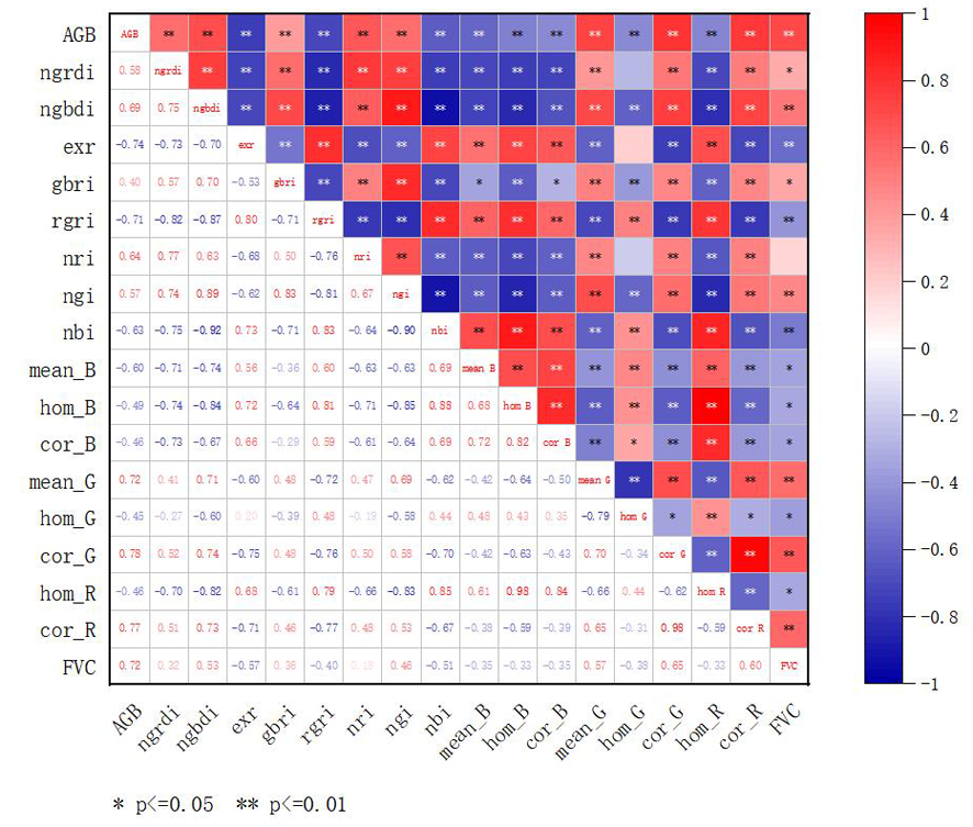
Fig. 1 Correlation between spectral, texture features, and coverage with AGB of Diarthron tianschanicum
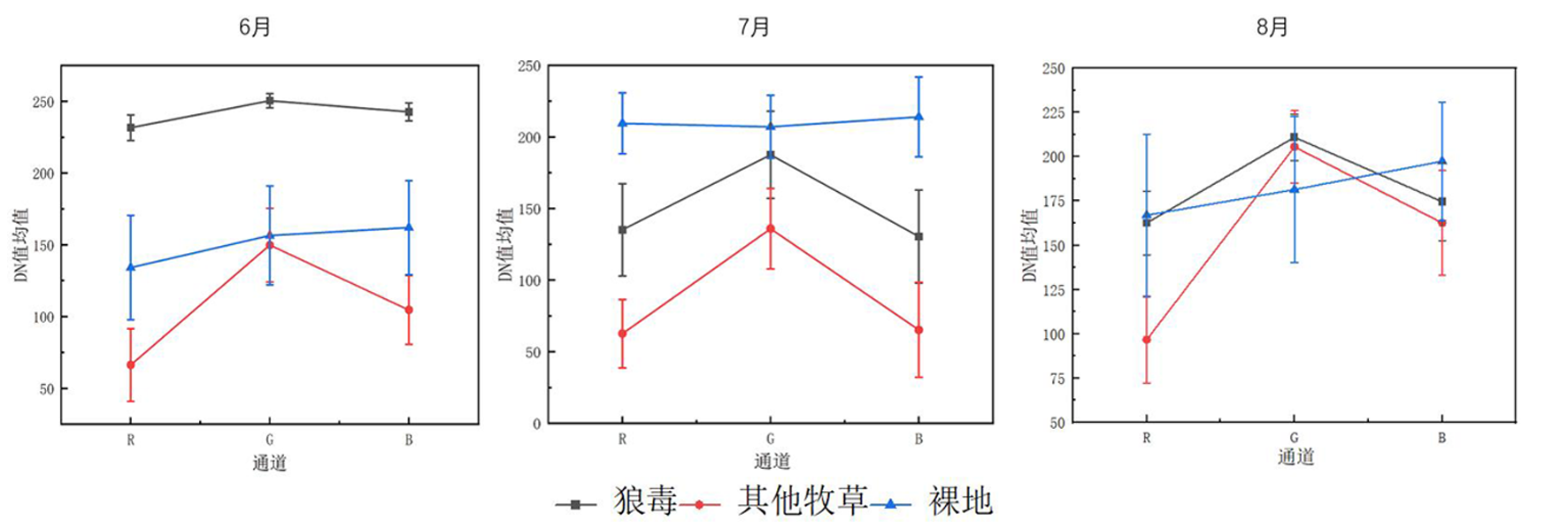
Fig. 2 Spectral differences between Diarthron tianschanicum and other vegetation in late June

Fig.3 Orthorectified image of the experimental area captured by the UAV

Fig. 4 Distribution map of Diarthron tianschanicum (after merging small patches)
| 模型输入 Model input | 模型公式 Model formula | 决定系数 R2 | 均方根 误差 RMSE (g/m2) |
|---|---|---|---|
| ExR | Y=26.173-2.028X | 0.544 | 29.315 |
| NRI | Y=-188.86+919.344X | 0.400 | 33.623 |
| NBI | Y=628.877-1 971.515X | 0.381 | 34.166 |
| NGRDI | Y=-65.082+582.556X | 0.318 | 35.860 |
| NGBDI | Y=--166.357+1 080.686X | 0.467 | 35.741 |
| NGI | Y=-843.908+2 060.782X | 0.308 | 36.122 |
| GBRI | Y=-24.727+59.308X | 0.137 | 40.334 |
| RGRI | Y=485.473-664.829X | 0.492 | 30.934 |
| mean_B | Y=280.073-8.103 624X | 0.345 | 35.144 |
| hom_B | Y=229.254-947.174X | 0.220 | 38.294 |
| cor_B | Y=145.009-217.139X | 0.193 | 38.999 |
| mean_G | Y=-52.137+3.867X | 0.511 | 30.360 |
| hom_G | Y=93.821-0.692X | 0.186 | 39.164 |
| cor_G | Y=-68.339+369.227X | 0.606 | 27.237 |
| hom_R | Y=-225.691-914.770 713X | 0.195 | 38.940 |
| cor_R | Y=-62.148+355.199 683X | 0.576 | 28.251 |
| FVC | Y=-15.636+161.079X | 0.501 | 30.664 |
Tab.4 Univariate linear estimation models and accuracy evaluation for AGB of Diarthron tianschanicum
| 模型输入 Model input | 模型公式 Model formula | 决定系数 R2 | 均方根 误差 RMSE (g/m2) |
|---|---|---|---|
| ExR | Y=26.173-2.028X | 0.544 | 29.315 |
| NRI | Y=-188.86+919.344X | 0.400 | 33.623 |
| NBI | Y=628.877-1 971.515X | 0.381 | 34.166 |
| NGRDI | Y=-65.082+582.556X | 0.318 | 35.860 |
| NGBDI | Y=--166.357+1 080.686X | 0.467 | 35.741 |
| NGI | Y=-843.908+2 060.782X | 0.308 | 36.122 |
| GBRI | Y=-24.727+59.308X | 0.137 | 40.334 |
| RGRI | Y=485.473-664.829X | 0.492 | 30.934 |
| mean_B | Y=280.073-8.103 624X | 0.345 | 35.144 |
| hom_B | Y=229.254-947.174X | 0.220 | 38.294 |
| cor_B | Y=145.009-217.139X | 0.193 | 38.999 |
| mean_G | Y=-52.137+3.867X | 0.511 | 30.360 |
| hom_G | Y=93.821-0.692X | 0.186 | 39.164 |
| cor_G | Y=-68.339+369.227X | 0.606 | 27.237 |
| hom_R | Y=-225.691-914.770 713X | 0.195 | 38.940 |
| cor_R | Y=-62.148+355.199 683X | 0.576 | 28.251 |
| FVC | Y=-15.636+161.079X | 0.501 | 30.664 |
| 模型输入量 Model input | 模型公式 Model formula | 因子 Factor | 决定 系数 R2 | 均方根误差 RMSE (g/m2) |
|---|---|---|---|---|
| VIs+FVC | Y=-0.888-1.907exr+93.623FVC | exr,FVC | 0.712 | 23.281 |
| TIs+FVC | Y=-160.891+7.335mean_G-9.285mean_B+1.439hom_G+994.878hom_B+60.704FVC | mean_G,mean_B,hom_G,hom_B,FVC | 0.830 | 17.398 |
| VIs+TIs | Y=-400.961+6.644mean_G+1 487.090hom_R-7.485mean_B+1.138hom_G+728.831ngbdi | mean_G,hom_R,mean_B,hom_G,ngbdi | 0.850 | 16.739 |
| VIS+TIS+FVC | Y=778.539-1.141exr+53.348FVC+1445.883hom_B+641.677nri+2.519mean_G-2152.134nbi | Exr,FVC,hom_B,nri,mean_G,nbi,ngi | 0.870 | 15.383 |
Tab.5 Multivariate linear stepwise regression estimation models and accuracy evaluation for AGB of Diarthron tianschanicum
| 模型输入量 Model input | 模型公式 Model formula | 因子 Factor | 决定 系数 R2 | 均方根误差 RMSE (g/m2) |
|---|---|---|---|---|
| VIs+FVC | Y=-0.888-1.907exr+93.623FVC | exr,FVC | 0.712 | 23.281 |
| TIs+FVC | Y=-160.891+7.335mean_G-9.285mean_B+1.439hom_G+994.878hom_B+60.704FVC | mean_G,mean_B,hom_G,hom_B,FVC | 0.830 | 17.398 |
| VIs+TIs | Y=-400.961+6.644mean_G+1 487.090hom_R-7.485mean_B+1.138hom_G+728.831ngbdi | mean_G,hom_R,mean_B,hom_G,ngbdi | 0.850 | 16.739 |
| VIS+TIS+FVC | Y=778.539-1.141exr+53.348FVC+1445.883hom_B+641.677nri+2.519mean_G-2152.134nbi | Exr,FVC,hom_B,nri,mean_G,nbi,ngi | 0.870 | 15.383 |
| 模型输入 Model input | 决定系数 R2 | 均方根误差 RMSE (g/m2) |
|---|---|---|
| VIs | 0.648 | 24.060 |
| TIs | 0.680 | 18.249 |
| FVC | 0.562 | 17.261 |
| VIs+TIs | 0.785 | 20.345 |
| VIs+FVC | 0.726 | 23.987 |
| TIs+FVC | 0.787 | 22.511 |
| VIs+TIs+FVC | 0.806 | 22.685 |
Tab.6 Artificial neural network forecast model and accuracy evaluation of AGB
| 模型输入 Model input | 决定系数 R2 | 均方根误差 RMSE (g/m2) |
|---|---|---|
| VIs | 0.648 | 24.060 |
| TIs | 0.680 | 18.249 |
| FVC | 0.562 | 17.261 |
| VIs+TIs | 0.785 | 20.345 |
| VIs+FVC | 0.726 | 23.987 |
| TIs+FVC | 0.787 | 22.511 |
| VIs+TIs+FVC | 0.806 | 22.685 |
| [1] | 江惠, 王明利, 励汀郁, 等. 新疆草原畜牧业转型升级:发展现状、现实困境与实现路径[J]. 华中农业大学学报, 2023, 42(5): 42-52. |
| JIANG Hui, WANG Mingli, LI Tingyu, et al. Transformation and upgrading of grassland animal husbandry in Xinjiang: development status, realistic dilemma and realization path[J]. Journal of Huazhong Agricultural University, 2023, 42(5): 42-52. | |
| [2] | 闫俊杰, 刘海军, 崔东, 等. 近15年新疆伊犁河谷草地退化时空变化特征[J]. 草业科学, 2018, 35(3): 508-520. |
| YAN Junjie, LIU Haijun, CUI Dong, et al. Spatiotemporal dynamics of grassland degradation in Yili Valley of Xinjiang over the last 15 years[J]. Pratacultural Science, 2018, 35(3): 508-520. | |
| [3] | 李宏, 陈卫民, 陈翔, 等. 新疆伊犁草原毒害草种类及其发生与危害[J]. 草业科学, 2010, 27(11): 171-173. |
| LI Hong, CHEN Weimin, CHEN Xiang, et al. Poisonous weed species and their harmfulness in the grassland of Yili regions, Xinjiang Uygur Autonomous Region of China[J]. Pratacultural Science, 2010, 27(11): 171-173. | |
| [4] | 李宏, 陈卫民, 王华, 等. 四种吡啶类除草剂防除白喉乌头的筛选试验[J]. 现代农药, 2010, 9(3): 48-50. |
| LI Hong, CHEN Weimin, WANG Hua, et al. Screening experiment of four pyridine herbicides on the Aconitum leucostomum[J]. Modern Agrochemicals, 2010, 9(3): 48-50. | |
| [5] | 范云豹, 宫兆宁, 赵文吉, 等. 基于高光谱遥感的植被生物量反演方法研究[J]. 河北师范大学学报(自然科学版), 2016, 40(3): 267-271. |
| FAN Yunbao, GONG Zhaoning, ZHAO Wenji, et al. Study on vegetation biomass inversion method based on hyperspectral remote sensing[J]. Journal of Hebei Normal University (Natural Science Edition), 2016, 40(3): 267-271. | |
| [6] | 刘建刚, 赵春江, 杨贵军, 等. 无人机遥感解析田间作物表型信息研究进展[J]. 农业工程学报, 2016, 32(24): 98-106. |
| LIU Jiangang, ZHAO Chunjiang, YANG Guijun, et al. Review of field-based phenotyping by unmanned aerial vehicle remote sensing platform[J]. Transactions of the Chinese Society of Agricultural Engineering, 2016, 32(24): 98-106. | |
| [7] | Candiago S, Remondino F, De Giglio M, et al. Evaluating multispectral images and vegetation indices for precision farming applications from UAV images[J]. Remote Sensing, 2015, 7(4): 4026-4047. |
| [8] |
Potgieter A B, George-Jaeggli B, Chapman S C, et al. Multi-spectral imaging from an unmanned aerial vehicle enables the assessment of seasonal leaf area dynamics of Sorghum breeding lines[J]. Frontiers in Plant Science, 2017, 8: 1532.
DOI PMID |
| [9] | Yang G J, Li C C, Wang Y J, et al. The DOM generation and precise radiometric calibration of a UAV-mounted miniature snapshot hyperspectral imager[J]. Remote Sensing, 2017, 9(7): 642. |
| [10] | Nie S, Wang C, Dong P L, et al. Estimating leaf area index of maize using airborne discrete-return LiDAR data[J]. IEEE Journal of Selected Topics in Applied Earth Observations and Remote Sensing, 2016, 9(7): 3259-3266. |
| [11] | Guo Q H, Su Y J, Hu T Y, et al. An integrated UAV-borne lidar system for 3D habitat mapping in three forest ecosystems across China[J]. International Journal of Remote Sensing, 2017, 38(8/9/10): 2954-2972. |
| [12] | 陶惠林, 徐良骥, 冯海宽, 等. 基于无人机数码影像的冬小麦株高和生物量估算[J]. 农业工程学报, 2019, 35(19): 107-116. |
| TAO Huilin, XU Liangji, FENG Haikuan, et al. Estimation of plant height and biomass of winter wheat based on UAV digital image[J]. Transactions of the Chinese Society of Agricultural Engineering, 2019, 35(19): 107-116. | |
| [13] | 张正健, 李爱农, 边金虎, 等. 基于无人机影像可见光植被指数的若尔盖草地地上生物量估算研究[J]. 遥感技术与应用, 2016, 31(1): 51-62. |
| ZHANG Zhengjian, LI Ainong, BIAN Jinhu, et al. Estimating aboveground biomass of grassland in zoige by visible vegetation index derived from unmanned aerial vehicle image[J]. Remote Sensing Technology and Application, 2016, 31(1): 51-62. | |
| [14] | 陈鹏飞, Nicolas Tremblay, 王纪华, 等. 估测作物冠层生物量的新植被指数的研究[J]. 光谱学与光谱分析, 2010, 30(2): 512-517. |
|
CHEN Pengfei, Nicolas Tremblay, WANG Jihua, et al. New index for crop canopy fresh biomass estimation[J]. Spectroscopy and Spectral Analysis, 2010, 30(2): 512-517.
PMID |
|
| [15] | 刘欣谊, 仲晓春, 陈晨, 等. 利用无人机图像颜色与纹理特征数据在小麦生育前期对产量进行预测[J]. 麦类作物学报, 2020, 40(8): 1002-1007. |
| LIU Xinyi, ZHONG Xiaochun, CHEN Chen, et al. Prediction of wheat yield using color and texture feature data of UAV image at early growth stage[J]. Journal of Triticeae Crops, 2020, 40(8): 1002-1007. | |
| [16] | 刘杨, 冯海宽, 孙乾, 等. 不同分辨率无人机数码影像的马铃薯地上生物量估算研究[J]. 光谱学与光谱分析, 2021, 41(5): 1470-1476. |
| LIU Yang, FENG Haikuan, SUN Qian, et al. Estimation study of above ground biomass in potato based on UAV digital images with different resolutions[J]. Spectroscopy and Spectral Analysis, 2021, 41(5): 1470-1476. | |
| [17] |
刘艳慧, 蔡宗磊, 包妮沙, 等. 基于无人机大样方草地植被覆盖度及生物量估算方法研究[J]. 生态环境学报, 2018, 27(11): 2023-2032.
DOI |
| LIU Yanhui, CAI Zonglei, BAO Nisha, et al. Research of grassland vegetation coverage and biomass estimation method based on major quadrat from UAV photogrammetry[J]. Ecology and Environmental Sciences, 2018, 27(11): 2023-2032. | |
| [18] | 杭艳红, 苏欢, 于滋洋, 等. 结合无人机光谱与纹理特征和覆盖度的水稻叶面积指数估算[J]. 农业工程学报, 2021, 37(9): 64-71. |
| HANG Yanhong, SU Huan, YU Ziyang, et al. Estimation of rice leaf area index combining UAV spectrum, texture features and vegetation coverage[J]. Transactions of the Chinese Society of Agricultural Engineering, 2021, 37(9): 64-71. | |
| [19] | 牛庆林, 冯海宽, 杨贵军, 等. 基于无人机数码影像的玉米育种材料株高和LAI监测[J]. 农业工程学报, 2018, 34(5): 73-82. |
| NIU Qinglin, FENG Haikuan, YANG Guijun, et al. Monitoring plant height and leaf area index of maize breeding material based on UAV digital images[J]. Transactions of the Chinese Society of Agricultural Engineering, 2018, 34(5): 73-82. | |
| [20] | Jiang B R, Wang P, Zhuang S, et al. Detection of maize drought based on texture and morphological features[J]. Computers and Electronics in Agriculture, 2018, 151: 50-60. |
| [21] | 刘咏梅, 胡念钊, 龙永清, 等. 无人机RGB影像在高寒草地狼毒入侵监测及盖度估算中的应用[J]. 中国草地学报, 2023, 45(2): 1-12. |
| LIU Yongmei, HU Nianzhao, LONG Yongqing, et al. Application of UAV RGB image in monitoring and coverage estimation of Stellera chamaejasme invasion in alpine grasslands, Qinghai-Tibet Plateau[J]. Chinese Journal of Grassland, 2023, 45(2): 1-12. | |
| [22] |
贾坤, 姚云军, 魏香琴, 等. 植被覆盖度遥感估算研究进展[J]. 地球科学进展, 2013, 28(7): 774-782.
DOI |
|
JIA Kun, YAO Yunjun, WEI Xiangqin, et al. A review on fractional vegetation cover estimation using remote sensing[J]. Advances in Earth Science, 2013, 28(7): 774-782.
DOI |
|
| [23] | 刘智彪. 基于无人机遥感的白喉乌头防效监测方法的研究[D]. 乌鲁木齐: 新疆农业大学, 2022. |
| LIU Zhibiao. Study on Monitoring Method of Aconitum Leucostomum Prevention Effect Based on Unmanned Aerial Vehicl Remote Sensing[D]. Urumqi: Xinjiang Agricultural University, 2022. | |
| [24] | Haralick R M, Shanmugam K, Dinstein I. Textural features for image classification[J]. IEEE Transactions on Systems, Man, and Cybernetics, 1973, SMC-3(6): 610-621. |
| [25] | 范宏. 基于UAV影像的草原毒害草识别检测方法研究——以白喉乌头为例[D]. 乌鲁木齐: 新疆大学, 2020. |
| FAN Hong. Research on Identification and Detection Method of Grassland Poisonous Grass Based on UAV Image[D]. Urumqi: Xinjiang University, 2020. | |
| [26] | 陈鹏, 冯海宽, 李长春, 等. 无人机影像光谱和纹理融合信息估算马铃薯叶片叶绿素含量[J]. 农业工程学报, 2019, 35(11): 63-74. |
| CHEN Peng, FENG Haikuan, LI Changchun, et al. Estimation of chlorophyll content in potato using fusion of texture and spectral features derived from UAV multispectral image[J]. Transactions of the Chinese Society of Agricultural Engineering, 2019, 35(11): 63-74. | |
| [27] | Karal Ö. Performance comparison of different kernel functions in SVM for different k value in k-fold cross-validation[C]// 2020 Innovations in Intelligent Systems and Applications Conference (ASYU). Istanbul, Turkey. IEEE, 2020: 1-5. |
| [28] | Chanda M, Biswas M. Plant disease identification and classification using Back-Propagation Neural Network with Particle Swarm Optimization[C]// 2019 3rd International Conference on Trends in Electronics and Informatics (ICOEI). Tirunelveli, India. IEEE, 2019: 1029-1036. |
| [29] | 王来刚, 贺佳, 郑国清, 等. 基于无人机多光谱遥感的玉米FPAR估算[J]. 农业机械学报, 2022, 53(10): 202-210. |
| WANG Laigang, HE Jia, ZHENG Guoqing, et al. Estimation of maize FPAR based on UAV multispectral remote sensing[J]. Transactions of the Chinese Society for Agricultural Machinery, 2022, 53(10): 202-210. | |
| [30] | 杨福芹, 冯海宽, 肖天豪, 等. 融合无人机影像光谱与纹理特征的冬小麦氮营养指数估算[J]. 农业现代化研究, 2020, 41(4): 718-726. |
| YANG Fuqin, FENG Haikuan, XIAO Tianhao, et al. Nitrogen nutrition index estimation in winter wheat by UAV spectral information and texture feature fusion[J]. Research of Agricultural Modernization, 2020, 41(4): 718-726. | |
| [31] | 汪小钦, 江洪, 傅银贞. 森林叶面积指数遥感研究进展[J]. 福州大学学报(自然科学版), 2009, 37(6): 822-828. |
| WANG Xiaoqin, JIANG Hong, FU Yinzhen. The progress of the forest LAI estimation from remote sensing data[J]. Journal of Fuzhou University (Natural Science Edition), 2009, 37(6): 822-828. | |
| [32] | Yu Z Y, Ustin S L, Zhang Z C, et al. Estimation of a new canopy structure parameter for rice using smartphone photography[J]. Sensors, 2020, 20(14): 4011. |
| [1] | HOU Zhengqing, YAN An, XIE Kaiyun, YUAN Yilin, XIA Wenqiu, XIAO Shuting, ZHANG Zhenfei, SUN Zhe. Estimation of aboveground biomass of Diarthron tianschanicum based on vegetation index fusion [J]. Xinjiang Agricultural Sciences, 2024, 61(11): 2787-2796. |
| [2] | HOU Zhixiong, JING Changqing, CHEN Chen, WANG Gongxin, GUO Wenzhang, ZHAO Weikang. Spatiotemporal Variation of Vegetation Coverage of Natural Grassland in Northern Xinjiang in Recent 20 Years and Its Relationship with Meteorological Factors [J]. Xinjiang Agricultural Sciences, 2023, 60(2): 464-471. |
| [3] | WU Jinlong, FENG Hongzu, MA Xiaoyan, WANG Lan, ZHANG Yalin, WU Gang. Screening of Fly Control Agents for Cotton Aphid in Cotton Fields in Xinjiang and Preliminary Report of Pesticide Reduction and Efficiency Improvement [J]. Xinjiang Agricultural Sciences, 2020, 57(1): 167-172. |
| [4] | LI Na, WANG Xin-jun, CHANG Meng-di, YAN Li-nan, XU Xiao-long. Response of Sparse Vegetation Patch Pattern to Precipitation Based on Landsat Image [J]. Xinjiang Agricultural Sciences, 2019, 56(10): 1895-1903. |
| [5] | LI Lu-man, GUO Peng, ZHANG Guo-shun, ZHOU Qian, WU Suo-zhi. Research on Area Information Extraction of Cotton Field Based on UAV Visible Light Remote Sensing [J]. Xinjiang Agricultural Sciences, 2018, 55(3): 548-555. |
| Viewed | ||||||||||||||||||||||||||||||||||||||||||||||||||
|
Full text 31
|
|
|||||||||||||||||||||||||||||||||||||||||||||||||
|
Abstract 94
|
|
|||||||||||||||||||||||||||||||||||||||||||||||||