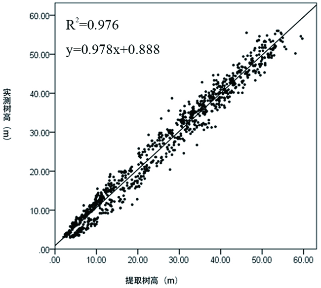
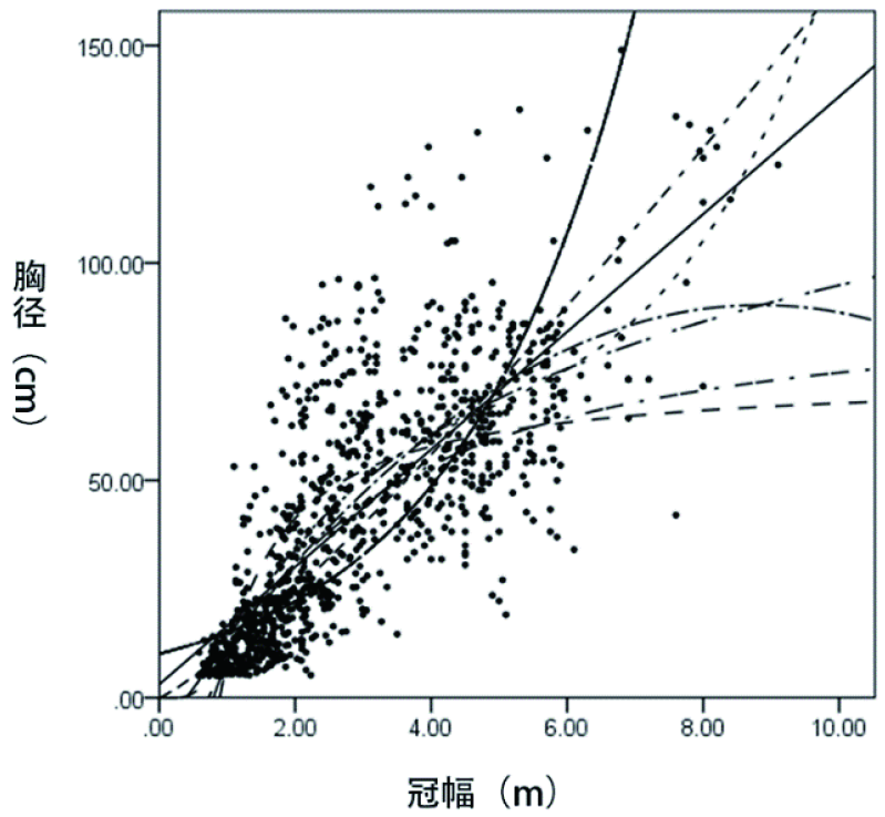
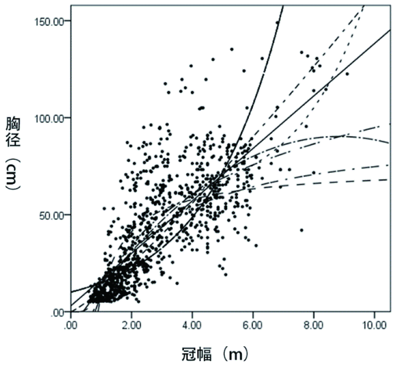
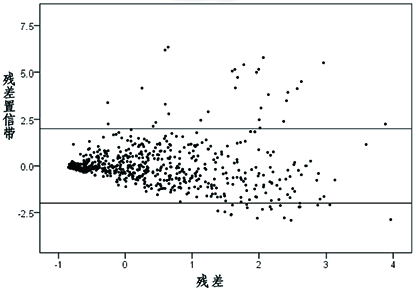
| [1] |
吴霜, 延晓冬, 张丽娟. 中国森林生态系统能值与服务功能价值的关系[J]. 地理学报, 2014, 69(3):334-342.
DOI
|
|
WU Shuang, YAN Xiaodong, ZHANG Lijuan. The relationship between forest ecosystem emergy and forest ecosystem service value in China[J]. Acta Geographica Sincia, 2014, 69(3):334-342.
|
| [2] |
于生华. 天然林资源共享保护工程在我区经济社会发展中的地位和重要性[J]. 新疆林业, 2015,(1):21-23.
|
|
YU Shenghua. The status and importance of natural forest resource sharing and protection project ineconomic and social development[J]. Forestry of Xinjiang, 2015,(1):21-23.
|
| [3] |
李明辉, 何风华, 刘云, 等. 天山云杉种群空间格局与动态[J]. 生态学报, 2005, 25(5):1000-1006.
|
|
LI Minghui, HE Fenghua, LIU Yun, et al. Spatial distribution pattern of tree individuals in the PiceaSchrenkianavartianshanica[J]. Acta Ecologica Sinica, 2005, 25(5):1000-1006.
|
| [4] |
王雅佩, 王振锡, 刘梦婷, 等. 基于无人机影像天山云杉林主伐迹地提取研究[J]. 新疆农业科学, 2019, 56(7):1315-1327.
|
|
WANG Yapei, WANG Zhengxi, LIU Mengting, et al. Research on estimation of stand density of regenerate PiceaSchrenkianavartianshanica based on UAV Image[J]. Xinjiang Agricultural Sciences, 2019, 56(7):1315-1327.
|
| [5] |
Song C, Dickinson M B, Su L, et al. Estimating average tree crown size using spatial information from Ikonos and QuickBird images: Across-sensor and across-site comparisons[J]. Remote Sensing of Environment, 2010, 114(5):1099-1107.
DOI
URL
|
| [6] |
史洁青, 冯仲科, 刘金成. 基于无人机遥感影像的高精度森林资源调查系统设计与试验[J]. 农业工程学报, 2017, 33(11):82-90.
|
|
SHI Jieqing, FENG Zhongke, LIU Jincheng. Design and experiment of high precision forest resource investigation system based on UAV remote sensing images[J]. Transactions of the Chinese Society of Agricultural Engineering, 2017, 33(11):82-90.
|
| [7] |
贾嘉辉. 高分遥感森林蓄积量估测算法研究[D]. 西安: 西安科技大学, 2017.
|
|
JIA Jiahui. Study on forest Stock Estimation Algorithm for high resolution remote sensing[D]. Xi’an: Xian Technology University, 2017.
|
| [8] |
曹霖. 基于Sentinel-2影像的延庆区森林蓄积量遥感估测研究[D]. 北京: 北京林业大学, 2019.
|
|
CAO Lin. Estimation of Pinuskesiya var. langbianensis Forest Stock Volume based on Sentinel-1A SAR Image Remote sensing Estimation of Forest stock in Yanqing District based on Sentinel-2 image[D]. Beijing: Beijing Forestry University, 2019.
|
| [9] |
李赟. 基于UAV高分影像的林木冠幅提取与蓄积量估测研究[D]. 南京: 南京林业大学, 2017.
|
|
LI Yun. Extraction and Volume Estimation of Tree Crown Based on High UAV Image[D]. Nanjing: Nanjing Forestry University, 2017.
|
| [10] |
李蕴雅. UAV/RS3D像对森林信息提取方法研究[D]. 北京:北京林业大学, 2016.
|
|
LI Yunya. UAV/RS3D Image Research on Forest Information Extraction Method[D]. Beijing: Beijing Forestry University, 2016.
|
| [11] |
周小成, 何艺, 黄洪宇, 等. 基于两期无人机影像的针叶林伐区蓄积量估算[J]. 林业科学, 2019, 55(11):117-125.
|
|
ZHOU Xiaocheng, HE Yi, HUANG Hongyu, et al. Estimation of coniferous forest cutting volume based on two-phase UAV image[J]. Scientia Silvae Sinicae. 2019, 55(11):117-125.
|
| [12] |
卢妮妮, 王新杰, 张鹏, 等. 不同林龄杉木胸径树高与冠幅的通径分析[J]. 东北林业大学学报, 2015, 43(4):12-16.
|
|
LU Nini, WANG Xinjie, ZHANG Peng, et al. Path analysis between diameter at breast height, height and crown width of cunnin ghamia lanceolata in different age[J]. Journal of Northeast Forestry University, 2015, 43(4):12-16.
|
| [13] |
李亚东, 曹明兰, 李长青, 等. 无人机森林航摄影像三维点云估测林分蓄积量研究[J]. 中南林业科技大学学报, 2019, 39(3):56-60.
|
|
LI Yadong, CAO Minglan, LI Changqin, et al. A research on three-dimensional point cloud estimation of forest stand volume by UAV forest aerial survey images[J]. Journal of Central South University of Forestry & Technology, 2019, 39(3):56-60.
|
| [14] |
王伟. 无人机影像森林信息提取与模型研建[D]. 北京: 北京林业大学, 2015.
|
|
WANG Wei. Information extraction and model construction of UAV image forest[D]. Beijing: Beijing Forestry University, 2015.
|
| [15] |
Wang L, Gong P, Biging G S. Individual Tree-Crown Delineation and Treetop Detection in High-Spatial-Resolution Aerial Imagery[J]. Photogrammetric Engineering & Remote Sensing, 2004, 70(3):351-358.
|
| [16] |
Lun Wu, Yunhai Zhang, Yong Gao, et al. Individual Tree-Crown Delineation and Treetop Detection in High-Spatial-Resolution Aerial Imagery[J]. Remote Sensing of Environment, 2004, 114(5):20-24.
|
| [17] |
Culvenor D S, Mikko Vastaranta, Markus Holopainen, et al. TIDA: an algorithm for the delineation of tree crowns in high spatial resolution remotely sensed imagery[J]. Computers & Geosciences, 2002, 28(1):33-44.
DOI
URL
|
| [18] |
李海奎, 法蕾. 基于分级的全国主要树种树高-胸径曲线模型[J]. 林业科学, 2011, 47(10):83-90.
|
|
LI Haikui, Fa Lei. Height-Diameter Model for Major Tree Species in China Using the Classified Height Method[J]. Scientia Silvae Sinicae, 2011, 47(10):83-90.
|
| [19] |
Iizuka, Iizuka, K., Yonehara, T., Itoh, M., Kosugi, Y. Estimating Tree Height and Diameter at Breast Height (DBH) from Digital Surface Models and Orthophotos Obtained with an Unmanned Aerial System for a Japanese Cypress (Chamaecyparisobtusa) Forest[J]. Remote Sensing, 2017, 10(1):277-8568.
DOI
URL
|
 ), Zhenxi WANG(