
新疆农业科学 ›› 2025, Vol. 62 ›› Issue (4): 917-928.DOI: 10.6048/j.issn.1001-4330.2025.04.016
闫兆杰1( ), 苏香玲2, 王振锡1(), 胡天祺1, 郝康迪1, 霍延霄1, 李凯旋1, 马嘉龙1
收稿日期:2024-09-05
出版日期:2025-04-20
发布日期:2025-06-20
通信作者:
王振锡(1977-),男,新疆喀什人,副教授,博士,硕士生导师,研究方向为林业3S技术及应用,(E-mail)wangzhenxi2003@163.com作者简介:闫兆杰(1999-),男,山东菏泽人,硕士研究生,研究方向为林业3S技术及应用,(E-mail)1539666818@qq.com
基金资助:
YAN Zhaojie1(), SU Xiangling2, WANG Zhenxi1(), HU Tianqi1, HAO Kangdi1, HUO Yanxiao1, LI kaixuan1, MA Jialong1
Received:2024-09-05
Published:2025-04-20
Online:2025-06-20
Supported by:摘要:
【目的】针对不同点云密度LiDAR数据,结合地面每木定位调查,采用冠层高度模型法提取天山云杉单木树高,比较分析不同密度LiDAR点云数据对单木树高的提取精度,为新疆天山云杉单木树高提取提供理论依据。【方法】以新疆农业大学实习林场天山云杉为研究对象,结合样地每木检尺并使用RTK对样地内单株天山云杉每木定位,通过布料模拟滤波算法,提取数字表面模型(DSM)和数字高程模型(DEM),二者作差得到冠层高度模型(CHM),通过CHM获取天山云杉单木树高。【结果】提取天山云杉单木树高最优点云密度为57.66个/m2,平均精度为93.28%,提取效果最差点云密度为1.60 个/m2,拟合度仅有0.754 6,单木识别率最优点云密度为138.53个/m2,识别率为98.7%,单木识别率最差点云密度为1.6个/m2,单木识别率为70.8%。【结论】通过布料模拟滤波算法提取DSM和DEM,计算得到CHM,通过CHM提取天山云杉单木树高是一种可行的办法,点云密度在2.76个/m2左右即可有效作为调查范围较大、成本有限的单木树高提取点云密度。
中图分类号:
闫兆杰, 苏香玲, 王振锡, 胡天祺, 郝康迪, 霍延霄, 李凯旋, 马嘉龙. 基于不同点云密度LiDAR数据的天山云杉单木树高提取[J]. 新疆农业科学, 2025, 62(4): 917-928.
YAN Zhaojie, SU Xiangling, WANG Zhenxi, HU Tianqi, HAO Kangdi, HUO Yanxiao, LI kaixuan, MA Jialong. Single tree height extraction based on different LiDAR density data of Tianshan spruce[J]. Xinjiang Agricultural Sciences, 2025, 62(4): 917-928.
| 样地号 Plot number | 平均胸径 Mean DBH (cm) | 平均树高 Average tree height (m) | 海拔 Elevation (m) | 株数(棵) Number of individuals (Trees) | 坡度 Slope (°) | 坡向 Aspect |
|---|---|---|---|---|---|---|
| S1 | 25.20 | 20.09 | 1 938.33 | 47 | 24 | 北偏东18 |
| S2 | 22.37 | 13.18 | 2 064.64 | 19 | 7 | 北偏东10 |
| S3 | 30.88 | 22.96 | 2 053.25 | 37 | 21 | 北偏东297 |
| S4 | 34.73 | 24.45 | 2 000.21 | 29 | 24 | 北偏东25 |
| S5 | 32.00 | 23.27 | 2 010.22 | 35 | 12 | 北偏东354 |
| S6 | 37.05 | 26.79 | 2 024.93 | 29 | 21 | 北偏东50 |
| S7 | 31.07 | 21.22 | 1 874.88 | 37 | 19 | 北偏东48 |
表1 样地基本信息
Tab.1 Basic information of the sample plot
| 样地号 Plot number | 平均胸径 Mean DBH (cm) | 平均树高 Average tree height (m) | 海拔 Elevation (m) | 株数(棵) Number of individuals (Trees) | 坡度 Slope (°) | 坡向 Aspect |
|---|---|---|---|---|---|---|
| S1 | 25.20 | 20.09 | 1 938.33 | 47 | 24 | 北偏东18 |
| S2 | 22.37 | 13.18 | 2 064.64 | 19 | 7 | 北偏东10 |
| S3 | 30.88 | 22.96 | 2 053.25 | 37 | 21 | 北偏东297 |
| S4 | 34.73 | 24.45 | 2 000.21 | 29 | 24 | 北偏东25 |
| S5 | 32.00 | 23.27 | 2 010.22 | 35 | 12 | 北偏东354 |
| S6 | 37.05 | 26.79 | 2 024.93 | 29 | 21 | 北偏东50 |
| S7 | 31.07 | 21.22 | 1 874.88 | 37 | 19 | 北偏东48 |
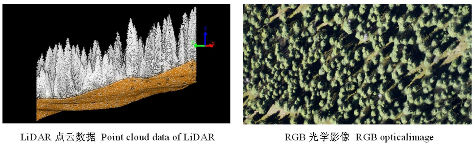
图1 华测AU20点云横剖及光学影像
Fig.1 CTI AU20 Point cloud cross-section and optical imaging
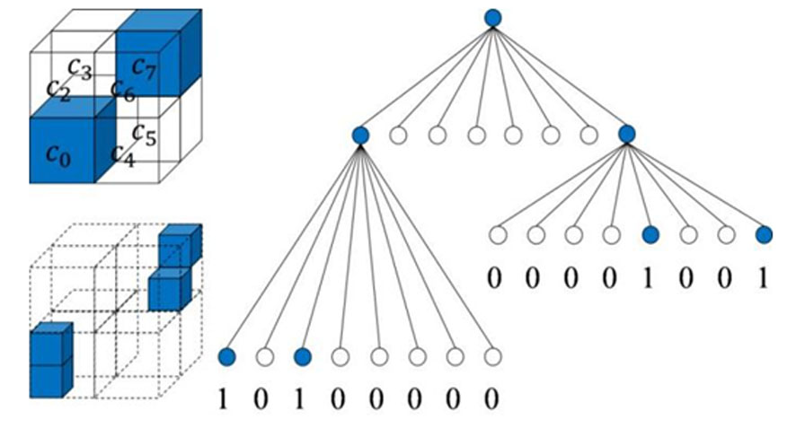
图2 八叉树分解
Fig.2 Octree decomposition
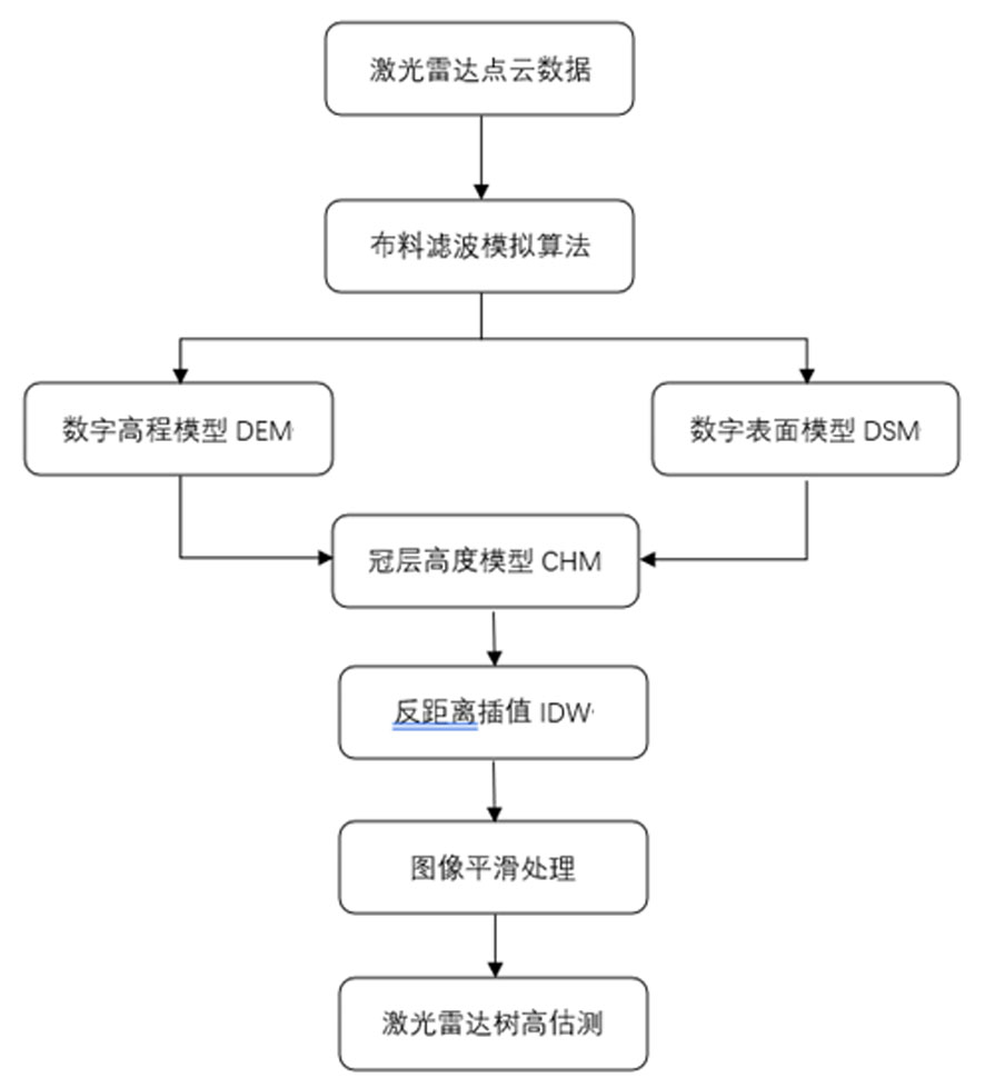
图3 树高提取的技术路线
Fig.3 Technical roadmap for tree height extraction
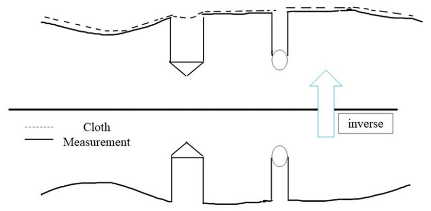
图4 布料模拟滤波原理示意
Fig.4 Schematic diagram of Cloth Simulation Filtering
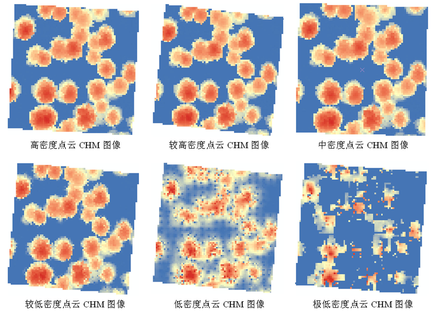
图5 不同点云密度下CHM图像
Fig.5 CHM image at different points of cloud density
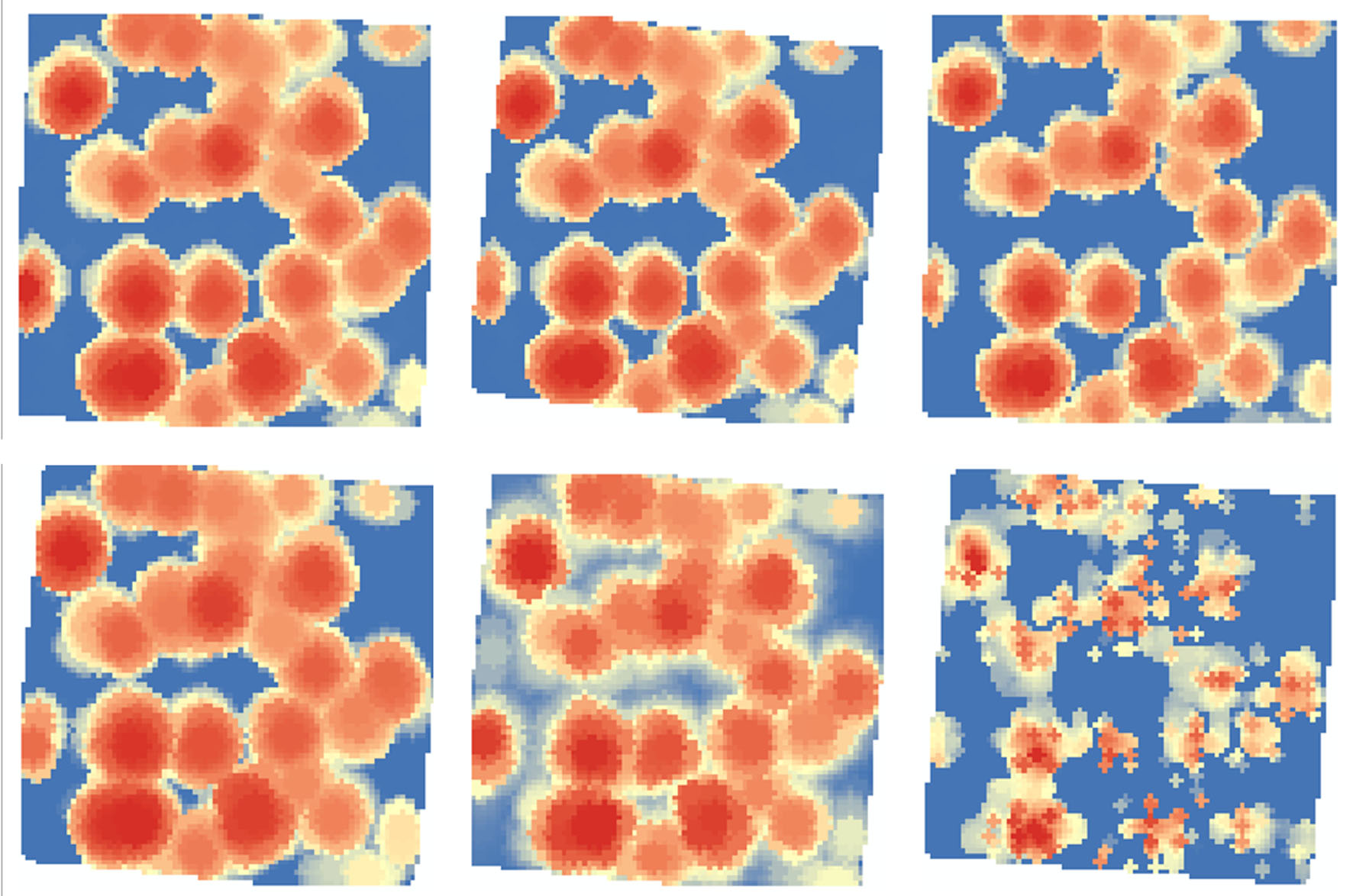
图6 Guass滤波处理效果
Fig.6 Guass filtering effect
| 密度 Densities | 实测株树(棵) Measured number of trees(Tree) | 提取株树(棵) Extracted number of trees(Tree) | 漏检数(棵) Missed number (Tree) | 过检数(棵) False alarm number(Tree) | 识别率 Recog-nition rate(%) |
|---|---|---|---|---|---|
| 高密度High density(138.53/m2) | 233 | 230 | 3 | 0 | 98.7 |
| 较高密度Higher density(100.57个/m2) | 233 | 229 | 4 | 0 | 98.3 |
| 中密度Middle density(57.66个/m2) | 233 | 220 | 13 | 0 | 94.4 |
| 低密度Low density(23.82个/m2) | 233 | 218 | 15 | 0 | 93.5 |
| 较低密度Lower density(2.76个/m2) | 233 | 213 | 20 | 0 | 91.4 |
| 极低密度Very low density(1.60个/m2) | 233 | 165 | 68 | 0 | 70.8 |
表2 不同点云密度单木识别效果
Tab.2 Recognition effect of single tree with different point cloud densities
| 密度 Densities | 实测株树(棵) Measured number of trees(Tree) | 提取株树(棵) Extracted number of trees(Tree) | 漏检数(棵) Missed number (Tree) | 过检数(棵) False alarm number(Tree) | 识别率 Recog-nition rate(%) |
|---|---|---|---|---|---|
| 高密度High density(138.53/m2) | 233 | 230 | 3 | 0 | 98.7 |
| 较高密度Higher density(100.57个/m2) | 233 | 229 | 4 | 0 | 98.3 |
| 中密度Middle density(57.66个/m2) | 233 | 220 | 13 | 0 | 94.4 |
| 低密度Low density(23.82个/m2) | 233 | 218 | 15 | 0 | 93.5 |
| 较低密度Lower density(2.76个/m2) | 233 | 213 | 20 | 0 | 91.4 |
| 极低密度Very low density(1.60个/m2) | 233 | 165 | 68 | 0 | 70.8 |
| 密度 Densities | 漏测胸径cm Missed measure- ment of DBH(max) | 漏测胸径cm Missed measure- ment of DBH(min) | 漏测树高m Missed measure- ment of tree height(max) | 漏测树高m Missed measure- ment of tree height(min) |
|---|---|---|---|---|
| 高密度High density(138.53个/m2) | 20.6 | 7.4 | 16.7 | 6.1 |
| 较高密度Higher density(100.57个/m2) | 38.5 | 6.5 | 30 | 7.3 |
| 中密度Middle density(57.66个/m2) | 24.3 | 6.3 | 22.3 | 5.9 |
| 低密度Low density(23.82个/m2) | 23.5 | 6.9 | 24.3 | 6.2 |
| 较低密度Lower density(2.76个/m2) | 28.4 | 6.1 | 28.7 | 5.8 |
| 极低密度Very low density(1.60个/m2) | 32 | 6.5 | 26.5 | 6.4 |
表3 不同密度漏检单木的胸径树高分布
Tab.3 Tree height distribution of DBH for missed single trees with different densities
| 密度 Densities | 漏测胸径cm Missed measure- ment of DBH(max) | 漏测胸径cm Missed measure- ment of DBH(min) | 漏测树高m Missed measure- ment of tree height(max) | 漏测树高m Missed measure- ment of tree height(min) |
|---|---|---|---|---|
| 高密度High density(138.53个/m2) | 20.6 | 7.4 | 16.7 | 6.1 |
| 较高密度Higher density(100.57个/m2) | 38.5 | 6.5 | 30 | 7.3 |
| 中密度Middle density(57.66个/m2) | 24.3 | 6.3 | 22.3 | 5.9 |
| 低密度Low density(23.82个/m2) | 23.5 | 6.9 | 24.3 | 6.2 |
| 较低密度Lower density(2.76个/m2) | 28.4 | 6.1 | 28.7 | 5.8 |
| 极低密度Very low density(1.60个/m2) | 32 | 6.5 | 26.5 | 6.4 |
| 点云密度 Densities | 树种 Tree species | 平均精度 EA(%) | 均方根误差 RMSE(m) | 平均绝对误差 MAE(m) | 相对误差 RE(%) | 置信椭圆检验F Confidence ellipse-F |
|---|---|---|---|---|---|---|
| 高密度High density(138.53个/m2) | 天山云杉 | 93.00 | 1.54 | 1.08 | 4.88 | 1.15 |
| 较高密度Higher density(100.57个/m2) | 92.21 | 1.70 | 1.15 | 5.32 | 1.1 | |
| 中密度Middle density(57.66个/m2) | 93.28 | 1.53 | 1.17 | 5.11 | 1.09 | |
| 低密度Low density(23.82个/m2) | 92.09 | 1.77 | 1.33 | 6 | 1.08 | |
| 较低密度Lower density(2.76个/m2) | 92.48 | 1.70 | 1.33 | 6.21 | 2.76 | |
| 极低密度Very low density(1.60个/m2) | 89.00 | 2.51 | 2.47 | 12.13 | 0.98 |
表4 不同密度激光雷达树高估测值精度评价指标
Tab.4 Accuracy evaluation index of height estimation of different density laser radar trees
| 点云密度 Densities | 树种 Tree species | 平均精度 EA(%) | 均方根误差 RMSE(m) | 平均绝对误差 MAE(m) | 相对误差 RE(%) | 置信椭圆检验F Confidence ellipse-F |
|---|---|---|---|---|---|---|
| 高密度High density(138.53个/m2) | 天山云杉 | 93.00 | 1.54 | 1.08 | 4.88 | 1.15 |
| 较高密度Higher density(100.57个/m2) | 92.21 | 1.70 | 1.15 | 5.32 | 1.1 | |
| 中密度Middle density(57.66个/m2) | 93.28 | 1.53 | 1.17 | 5.11 | 1.09 | |
| 低密度Low density(23.82个/m2) | 92.09 | 1.77 | 1.33 | 6 | 1.08 | |
| 较低密度Lower density(2.76个/m2) | 92.48 | 1.70 | 1.33 | 6.21 | 2.76 | |
| 极低密度Very low density(1.60个/m2) | 89.00 | 2.51 | 2.47 | 12.13 | 0.98 |

图7 不同点云密度估测树高和实测树高回归关系
Fig.7 Regression relationship between estimated tree height and measured tree height of cloud density at different points

图8 不同密度激光雷达树高估测值的置信椭圆区间
Fig.8 Confidence ellipse interval for height estimates of different density lidar trees
| [1] | 王燕, 赵士洞. 天山云杉林生物生产力的地理分布[J]. 植物生态学报, 2000, 24(2): 186-190. |
| WANG Yan, ZHAO Shidong. Productivity pattern of Picea schrenkiana var. tianschanica forest[J]. Acta Phytoecologica Sinica, 2000, 24(2): 186-190. | |
| [2] | 陈华豪. 用F=(1/2[n(a-A)-2+2(a-A)(b-B)sum from i=1 tonx_i+(b-B-2)Σx_i-2])/(1/n2)sun from i=1 ton[y_1-(a+bx_1)]-2)检验材积表适用性的推导[J]. 林业资源管理, 1980, (1): 18-24. |
| CHEN Huahao.F=(1/2[n(a-A)-2+2(a-A)(b-B)sum from i=1 tonx_i+(b-B-2)Σx_i-2])/(1/n2)sun from i=1 ton[y_1-(a+bx_1)]-2) of Derivation of suitability for testing volume tables[J]. Forestry resource management, 1980, (1): 18-24. | |
| [3] | 郝红科. 基于机载激光雷达的森林参数反演研究[D]. 杨凌: 西北农林科技大学, 2019. |
| HAO Hongke. Inversion of forest parameters based on airborne LiDAR[D]. Yangling: Northwest A & F University, 2019. | |
| [4] |
赵颖慧, 杨海城, 甄贞. 基于ULS、TLS和超声测高仪的天然次生林中不同林冠层树高估测[J]. 南京林业大学学报(自然科学版), 2021, 45(4): 23-32.
DOI |
| ZHAO Yinghui, YANG Haicheng, ZHEN Zhen. Tree height estimations for different forest canopies in natural secondary forests based on ULS, TLS and ultrasonic altimeter systems[J]. Journal of Nanjing Forestry University (Natural Sciences Edition), 2021, 45(4): 23-32. | |
| [5] | 庞勇, 李增元, 陈尔学, 等. 激光雷达技术及其在林业上的应用[J]. 林业科学, 2005, 41(3): 129-136. |
| PANG Yong, LI Zengyuan, CHEN Erxue, et al. Lidar remote sensing technology and its application in forestry[J]. Scientia Silvae Sinicae, 2005, 41(3): 129-136. | |
| [6] | 许天一, 甄贞, 赵颖慧. 基于UAV-LiDAR和误差变量回归的落叶松人工林单木参数估测[J]. 中南林业科技大学学报, 2023, 43(7): 52-64. |
| XU Tianyi, ZHEN Zhen, ZHAO Yinghui. Estimation of individual tree parameters of larch plantations based on UAV-LiDAR and error-in-variable regression[J]. Journal of Central South University of Forestry & Technology, 2023, 43(7): 52-64. | |
| [7] | 代婷婷. 基于UAV和TLS的林木参数提取[D]. 南京: 南京林业大学, 2019. |
| DAI Tingting. Extraction of tree parameters based on UAV and TLS[D]. Nanjing: Nanjing Forestry University, 2019. | |
| [8] |
周烨, 刘云波, 郑丽波, 等. 多平台点云数据的单木参数提取精度分析[J]. 测绘通报, 2022,(7): 168-172.
DOI |
|
ZHOU Ye, LIU Yunbo, ZHENG Libo, et al. Precision analysis of single tree parameter extraction for multi-platform point cloud data[J]. Bulletin of Surveying and Mapping, 2022,(7): 168-172.
DOI |
|
| [9] | 王鑫运, 黄杨, 邢艳秋, 等. 基于无人机高密度LiDAR点云的人工针叶林单木分割算法[J]. 中南林业科技大学学报, 2022, 42(8): 66-77. |
| WANG Xinyun, HUANG Yang, XING Yanqiu, et al. The single tree segmentation of UAV high-density LiDAR point cloud data based on coniferous plantations[J]. Journal of Central South University of Forestry & Technology, 2022, 42(8): 66-77. | |
| [10] | 张翔, 刘洋, 玉山, 等. 基于无人机激光雷达和多光谱数据的森林树高提取方法研究[J]. 森林工程, 2023, 39(1): 29-36. |
| ZHANG Xiang, LIU Yang, YU Shan, et al. Research on extraction method of forest tree height based on unmanned aerial vehicle LiDAR and multispectral data[J]. Forest Engineering, 2023, 39(1): 29-36. | |
| [11] | 胡天祺, 王振锡, 郝康迪, 等. 基于WorldView-3遥感影像与机载LiDAR的单木树高提取[J]. 干旱区资源与环境, 2022, 36(10): 166-175. |
| HU Tianqi, WANG Zhenxi, HAO Kangdi, et al. Extraction of individual tree height using WorldView-3 remote sensing images and airborne LiDAR[J]. Journal of Arid Land Resources and Environment, 2022, 36(10): 166-175. | |
| [12] | 郭阳光, 夏凯, 杨垠辉, 等. 基于无人机影像的山核桃单木检测及冠幅与树高的提取[J]. 林业工程学报, 2023, 8(4): 159-166. |
| GUO Yangguang, XIA Kai, YANG Yinhui, et al. Research on single tree detection and crown diameter and tree height extraction of pecan forest based on UAV images[J]. Journal of Forestry Engineering, 2023, 8(4): 159-166. | |
| [13] | 余铸. 基于垂直结构分类的机载激光雷达亚热带森林参数估测和相容性模型[D]南宁: 广西大学, 2022. |
| YU Z. Estimation and compatibility model of airborne LiDAR subtropical forest parameters based on vertical structure classification[D]. Nanning: Guangxi University, 2022. | |
| [14] | 潘存德. 新疆山地天然林及其群落演替与更新[J]. 新疆林业, 2020,(5): 8-14. |
| PAN Cunde. Natural forests and their community succession and renewal in mountainous areas of Xinjiang[J]. Forestry of Xinjiang, 2020,(5): 8-14. | |
| [15] | 赵夫群, 李映萱. 基于点重要性判断的点云简化[J]. 计算机系统应用, 2023, 32(9): 197-202. |
| ZHAO Fuqun, LI Yingxuan. Point cloud simplification based on point importance judgment[J]. Computer Systems and Applications, 2023, 32(9): 197-202. | |
| [16] | Huang F, Peng S Y, Chen S Y, et al. VO-LVV—a novel urban regional living vegetation volume quantitative estimation model based on the voxel measurement method and an octree data structure[J]. Remote Sensing, 2022, 14(4): 855. |
| [17] | Huang Z, Yang X, Min J, et al. Collision detection algorithm on abrasive belt grinding blisk based on improved octree segmentation[J]. The International Journal of Advanced Manufacturing Technology, 2022, 118(11): 4105-4121. |
| [18] | 刘玮, 李岩, 贾科, 等. 非结构环境下一种改进的区域生长点云分割方法[J]. 科学技术与工程, 2021, 21(27): 11650-11655. |
| LIU Wei, LI Yan, JIA Ke, et al. An improved segmentation method of regional growth point cloud in unstructured environment[J]. Science Technology and Engineering, 2021, 21(27): 11650-11655. | |
| [19] | Zhang W M, Qi J B, Wan P, et al. An easy-to-use airborne LiDAR data filtering method based on cloth simulation[J]. Remote Sensing, 2016, 8(6): 501. |
| [20] | Xu X J, Zhou Z S, Tang Y, et al. Individual tree crown detection from high spatial resolution imagery using a revised local maximum filtering[J]. Remote Sensing of Environment, 2021, 258: 112397. |
| [21] | Dralle K, Rudemo M. Automatic estimation of individual tree positions from aerial photos[J]. Canadian Journal of Forest Research, 1997, 27(11): 1728-1736. |
| [22] | 张凝, 张晓丽, 叶栗. 基于改进爬峰法高分辨率遥感影像分割的树冠提取[J]. 农业机械学报, 2014, 45(12): 294-300. |
| ZHANG Ning, ZHANG Xiaoli, YE Li. Tree crown extraction based on segmentation of high-resolution remote sensing image improved peak-climbing algorithm[J]. Transactions of the Chinese Society for Agricultural Machinery, 2014, 45(12): 294-300. | |
| [23] | Hyyppä J, Hyyppä H, Leckie D, et al. Review of methods of small-footprint airborne laser scanning for extracting forest inventory data in boreal forests[J]. International Journal of Remote Sensing, 2008, 29(5): 1339-1366. |
| [24] | LA Gaveau D, Hill R A. Quantifying canopy height underestimation by laser pulse penetration in small-footprint airborne laser scanning data[J]. Canadian Journal of Remote Sensing, 2003, 29(5): 650-657. |
| [25] | Gonçalves-Seco, González-Ferreiro, Diéguez-Aranda, et al. Assessing the attributes of high-density Eucalyptus globulus stands using airborne laser scanner data[J]. International Journal of Remote Sensing, 2011, 32(24): 9821-9841. |
| [26] | Goodwin N R, Coops N C, Culvenor D S. Assessment of forest structure with airborne LiDAR and the effects of platform altitude[J]. Remote Sensing of Environment, 2006, 103(2): 140-152. |
| [27] | 赵朝贺, 王玉军, 杨礼平, 等. 基于机载LiDAR数据的株数及树高提取[J]. 林业科技通讯, 2023,(1): 78-80. |
| ZHAO Chaohe, WANG Yujun, YANG Liping, et al. Tree number and height extraction based on airborne LiDAR data[J]. Forest Science and Technology, 2023,(1): 78-80. | |
| [28] | 董巍, 王振锡, 陈哲, 等. 基于机载激光雷达影像的天山云杉林树高提取算法研究[J]. 新疆农业大学学报, 2021, 44(6): 455-9. |
| DONG Wei, WANG Zhenxi, CHEN Ze, et al. Research on tree height extraction algorithm of Spruce forest in Tianshan Mountains based on airborne Lidar images[J]. Journal of Xinjiang Agricultural University, 2021, 44(6): 455-9. |
| [1] | 李振瑜, 耿召坤, 赵善超, 高玉德, 王褚, 王世伟, 潘存德, 张国林. 天山云杉林地上植被与土壤种子库物种相似性[J]. 新疆农业科学, 2024, 61(9): 2230-2236. |
| 阅读次数 | ||||||
|
全文 |
|
|||||
|
摘要 |
|
|||||